ID: 111
Open
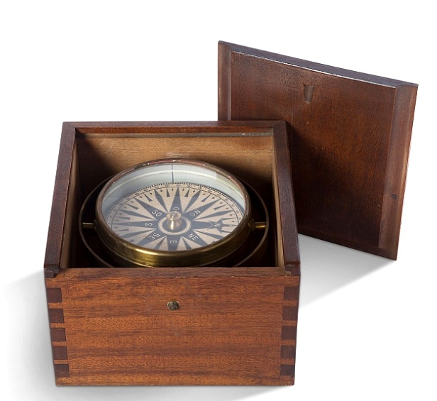
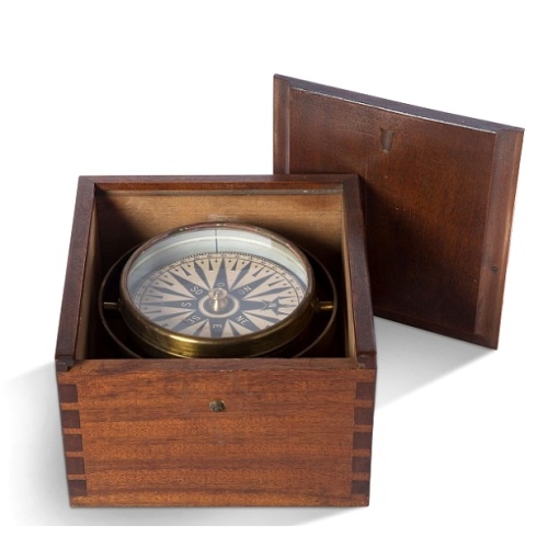
Early 19th century magnetic dry card compass with wooden bowl,
BuyNow for $1.750
- Maker :
- ANONYMOUS
- Place :
- Unknown
- Date :
- ca. 1800
- Color :
- In original color
- Height mm.:
- 150
- Width mm.:
- 220
- Condition :
- In original wooden case, in gimbals and oak surround. 15,5 x 22,5 x 23 cm
- Bibliography :
- -
- Seller's ref. :
- 48677
This item is offered by Paulus_Swaen_Old_Maps
See other Items from this seller- Postage
-
Standard Shipping
$0 to Netherlands
- Select Country
- Zip/Post Code
- Quantity
$1.750
Description
Brass dry rose marine compass, in its mahogany case. The mariner's compass, which enabled mariners to know the direction in which they were sailing, has always been one of the most important navigational instruments.This example is mounted in a wooden box to keep it safe.. The compass itself is mounted on brass gimbals to keep it steady on a moving ship. It has a single iron needle with a brass cap that rests on a spike projecting from the bottom of the bowl, which also contains some lead to weigh it down and keep it steady.
The compass card is made of paper and is marked both in degrees and with the points of the compass.
Some small blobs of sealing wax remain on the underside of the card (they were originally put there to keep it balanced).

Descriptio Transisalaniae.
An original early 17th century copper engraved miniature antique map of the eastern Dutch region of Overijssel by Petrus Bertius. The title is displayed in a simple strapwork cartouche with the further title in bold letters above the map. Zwolle the capital city is engraved, along with Lochem, Zutphen, Apeldoorn, Deventer, Hengelo and Enschede. From the Bertius atlas Tabularum geographicarum contractarum. Bertius (1565-1629) was a Flemish cartographer, theologian, historian and geographer. Altho...
$100
Maker : LANGENES, B. / BERTIUS, P.
Place : Amsterdam
Date : 1606

Brabantiae Descriptio.
In an inset Mechelen and surroundings. Decorative scale and title cartouche with dedicational initials, which may refer to Laurentius Michaelis, who may be connected with the Mechelen inset map.Dare to go in Black. All early maps were printed in black and white, and many were kept that way for a long time. A black and white map in an early and strong impression is a rarity nowadays, being so many examples recently colored up!
$350
Maker : ORTELIUS, A.
Place : Antwerp, 1598
Date : 1598
Partie septentrionale des Pays-Bas comprenant .. des provinces unies. . .
Finely and crisply engraved map of Netherlands.Venetian edition of Giles Didier Robert De Vaugondy's map from Atlas Universel printed in 1776-84.Ornamental title cartouche in the upper right corner, including a large vessel in the North Sea.
$450
Maker : SANTINI, P. / REMONDINI, M.
Place : Venice, 1776 - 1784
Date : 1784

Kaart van de Reede van Batavia met de verschillende vaarwaters naar dezelve trigometrisch opgenomen op last van deb schout bijnacht E.Lucas.
Very large and rare so-called blue-black chart centered on Jakarta's harbor.The chart is prepared by B.G.Escher, I.A.C. Eschauzier, B.H.Staring and E.H.Boom during an expedition in 1841 by the ships Krokodil and Hekla. The chart is engraved by J.C.Zurcher and updated for and published in 1847 by Jacob Swart. When Gerard Hulst van Keulen died in 1801, his widow ran the firm until her death in 1810, at which time Johannes Hulst van Keulen became the last van Keulen to run the firm.In 1823, Jacob S...
$1.800
Maker : HULST VAN KEULEN, Wed. G.
Place : Amsterdam
Date : (1841) 1847
Postage & Shipping
-
Item Location
Terms and conditions - Item Location
- Amsterdam, , Netherlands
- Ships To
- United States, United Kingdom, Albania, Argentina, Armenia, Australia, Azerbaijan, Bahamas, Belgium, Bermuda, Cambodia, Canada, Chile, China, Croatia, Cyprus, Czech Republic, Denmark, Estonia, Finland, France, Germany, Gibraltar, Greece, Greenland, Guatemala, Hong Kong, Iceland, India, Indonesia, Israel, Italy, Japan, Latvia, Lithuania, Luxembourg, Malta, Mexico, Monaco, Netherlands, Norway, Singapore, Spain, Sweden, Switzerland, Turkey
- Pick-ups
- No pick-ups
This item is owned and offered by the seller Paulus_Swaen_Old_Maps - All items are available for immediate sale, offered subject to prior sale.
Invoices are created by the seller by using our shopping cart or be prepared by the seller the day following the order and are emailed to you.
Items offeres by different sellers are invoiced separately.
Shipping fees are extra. The buyer is responsible for all applicable taxes, including any VAT, customs clearance, import duties, or equivalent costs arriving at the customer's home border. Payment is due on receipt of the invoice. The item(s) are shipped as soon as possible after receipt of your payment.
Before buying please read the complete Terms Conditions of Sale.
- Payment Methods
- Visa, Mastercard, Bank Transfer, American Express, iDEAL, Google Pay
- Returns Accepted
- No
Post Message
Feel free to ask the seller a question. Please note that the seller could be located in an area with a different time zone. Our seller will do their best to respond within 24 hours.Post your message below.
Sign in to ask the seller a question.