ID: 164
Open

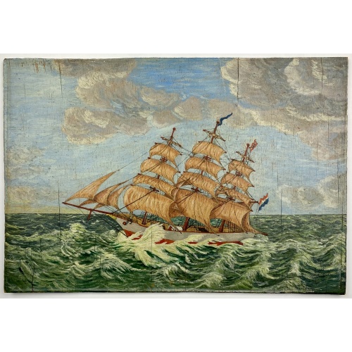
Painting made by a sailor, signed W. Welman.
Painting made by a sailor, signed W.Welman.
BuyNow for €250
- Maker :
- WELMAN, W.
- Place :
- Unknown
- Date :
- c.1960
- Color :
- Oil
- Height mm.:
- 245
- Width mm.:
- 365
- Condition :
- Good
- Bibliography :
- -
- Seller's ref. :
- 86465-1500
This item is offered by Papyro
See other Items from this seller- Postage
-
Standard Shipping
€25 to Netherlands
- Select Country
- Zip/Post Code
- Quantity
€250
Description
Panel from a thee-box, with a painting of a ship. Signed in lower right "Hr. W. Welman". Complete with a naive painting of a square-rigged sailing ship rigged as a three-masted barque.Sailors folk art and crafts come in many different varieties, most items were made for loved ones back home or were made to sell when in port to increase income. The skill and ingenuity of the sailor were second to none and they utilized long periods of time aboard, whilst off watch to hone their skills.
![[Lot of 3] Celestial chart depicting astronomical division of the earth.](/uploads/cache/84235-500x500.jpg)
[Lot of 3] Celestial chart depicting astronomical division of the earth.
A chart depicting the astronomical division of the earth. With on both sides a descriptionary text. All within an elaborate and very decorative border. A very fine item.Claude Buy de Mornas (d. 1783), géographe du roi (1764). Atlas Méthodique et Elémentaire de Géographie et d' Histoire, 1761, Atlas Historique et Géographique, 1762. A chart depicting the astronomical division of the earth. With on both sides a descriptionary text. All within an elaborate and very decorative border. A very fi...
€250
Maker : BUY DE MORNAS, C.
Place : Paris, L.C. Desnos
Date : 1761.

A Map of the most Inhabited part of New England containing the Provinces of Massachusetts Bay and New Hampshire, with the Colonies of Connecticut and Rhode Island.
A copper engraving in four sheets, published in Georges Louis Le Rouge, in his "Atlas Ameriqua in Septentrional Contenant les details des differentes provinces, de ce vaste continent, traduit des cartes levées par ordre du Gouvernement Britannique". This is a very close copy of the second edition, the second issue of the Jefferys-Green map, even down to the spelling, in the statement of sources, of Connecticut with 'k's (but translated into French). The title cartouche is also a straight copy, ...
€4.000
Maker : LE ROUGE, G. L.
Place : Paris, 1777
Date : Paris, 1777
![[Lot of 8 maps and prints] Norvegiae Maritimae ab Elf-burgo ad Dronten / Pascaert van Noorwegen streckende van Elf-burg tot Dronten.](/uploads/cache/84130-500x500.jpg)
[Lot of 8 maps and prints] Norvegiae Maritimae ab Elf-burgo ad Dronten / Pascaert van Noorwegen streckende van Elf-burg tot Dronten.
Norvegiae Maritimae ab Elf-burgo ad Dronten / Pascaert van Noorwegen streckende van Elf-burg tot Dronten.Frederick de Wit's fine sea chart of southern Norway. An attractive sea chart of southern Norway and Sweden, richly embellished with a stunning large decorative title cartouche, showing the drying of cod. A lot of 8 maps including:-Carte du Detroit de Waeigats ou de Nassau 1758 -Partie de la Mer Glaciale 1758 -RVGIA VSEDO MIAE ET IVLINAE -Carte du Spits-Berg 1758 -Carte Des Pais Habites par�...
€900
Maker : DE WIT, Frederick.
Place : Amsterdam
Date : 1675

Paskaerte van het inkoomen van de MAES, Tot aen 't Eylandt Roosenburgh als mede 't Inkoomen van 't Goereesche Gat.. / Pascaert van 't Eylandt Roosenburg door de Oude en Nieuwe Maes....
A very attractive sea chart on two sheets of the mouth of the river Maas. The left sheet shows Dordrecht, Rotterdam and the fortress at Willemstad. Rghthand sheet depicts "Hook of Holland" showing Goeree and Brielle. Elaborate sea-themed cartouches and Poseidon vignette on the western sheet. Both scale cartouches decorated with cornucopia. Each include rhumb lines and a compass rose. Nicely detailed depths and banks. Set of 2 charts when joined 110 x 49 cm.- Paskaerte van het Inkoomen van de...
€1.500
Maker : KEULEN, J. van.
Place : Amsterdam
Date : 1680
Postage & Shipping
-
Item Location
Terms and conditions - Item Location
- Amsterdam, , Netherlands
- Ships To
- Worldwide
- Pick-ups
- Buyer can pick-up
This item is owned and offered by the seller Papyro - All items are available for immediate sale, offered subject to prior sale.
Invoices are created by the seller by using our shopping cart or be prepared by the seller the day following the order and are emailed to you.
Items offeres by different sellers are invoiced separately.
Shipping fees are extra. The buyer is responsible for all applicable taxes, including any VAT, customs clearance, import duties, or equivalent costs arriving at the customer's home border. Payment is due on receipt of the invoice. The item(s) are shipped as soon as possible after receipt of your payment.
Before buying please read the complete Terms Conditions of Sale.
- Payment Methods
- Visa, Mastercard, Bank Transfer, PayPal
- Returns Accepted
- Yes
Post Message
Feel free to ask the seller a question. Please note that the seller could be located in an area with a different time zone. Our seller will do their best to respond within 24 hours.Post your message below.
Sign in to ask the seller a question.