
ID: 150
Closed
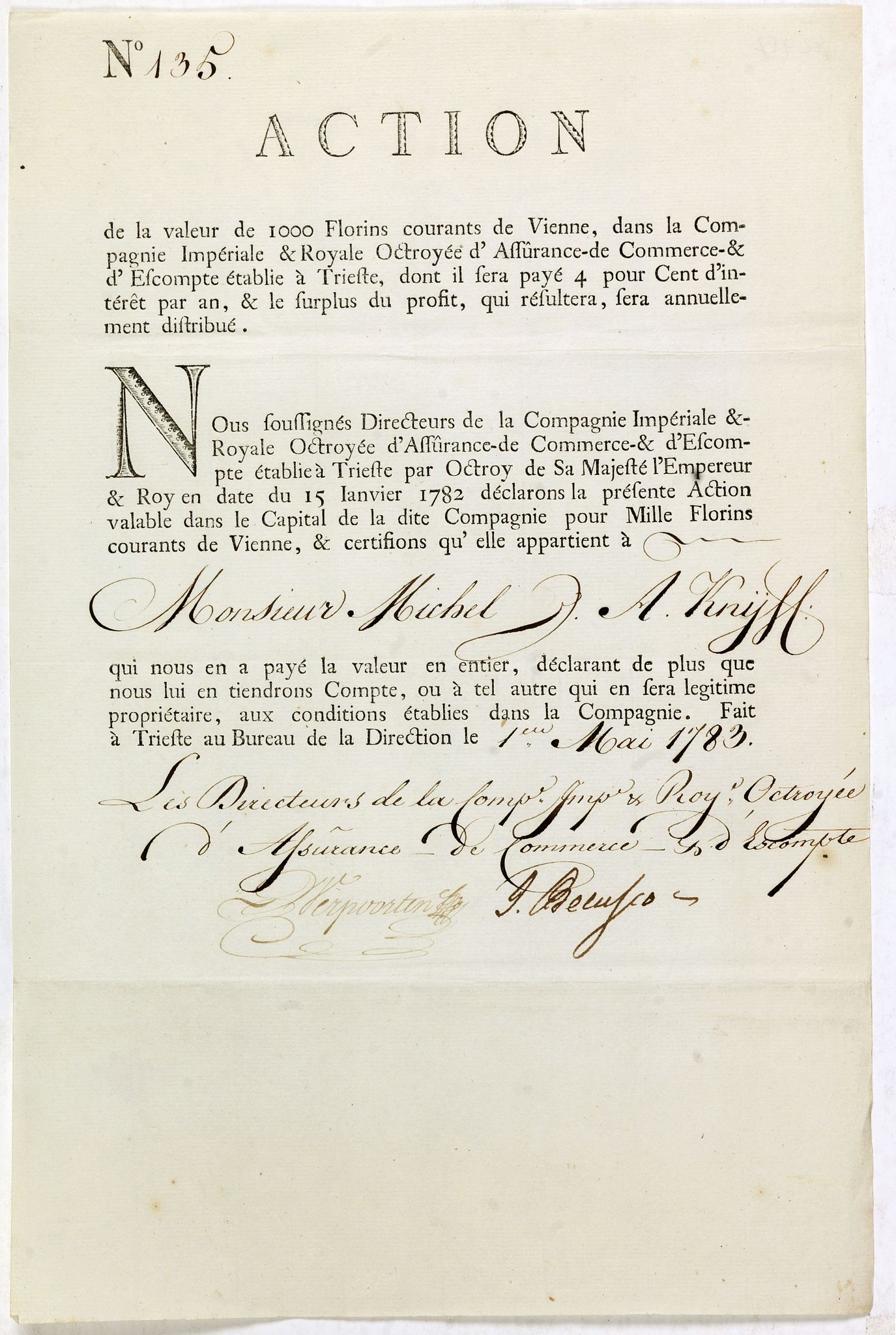
Share of 1000 Florins to Michel de Knyff. N° 135.
BuyNow for $1.500
- Maker :
- COMPAGNIE IMPERIALE & ROYALE
- Place :
- Trieste
- Date :
- 1782 - 1783
- Color :
- Uncoloured
- Height mm.:
- 335
- Width mm.:
- 215
- Condition :
- Size of paper sheet 335 x 215mm. Three horizontal fold. Very fine condition.
- Bibliography :
- Généalogie de Knyff, in: Annuaire de la noblesse de Belgique, Brussel, 1852.
- Seller's ref. :
- 42957
This item is offered by Paulus_Swaen_Old_Maps
See other Items from this seller- Postage
-
Standard Shipping
$0 to United States
- Select Country
- Zip/Post Code
- Quantity
$1.500
Description
Share of 1000 Florins, paid in four tranches at 250 Florins of Vienna, from "Compagnie Imperiale & Royale Octroyee d'Assurance de Commerce & d'escompte." dated in manuscript, Trieste, May 1, 1783. Share made out to Michel de Knyff of Antwerp.In their high-flying plans, the proud Habsburg monarchy very often relied on the money of the wealthy Antwerp bankers and wholesalers, who at that time belonged to the Austrian Netherlands. Among the financiers was the famous bank of Ertborn & Fils among many Antwerp bankers, noble and rich families.
This Share made out to Michel de Knyff (1720-1797), who was a member of a noble Belgium family. Michel de Knyff was the son of Jacques Knyff (1681-1756) who in 1719, was granted by the Emperor Charles VI, along the irregular channel of the Imperial Chancellery, the Knight's title of the Holy Roman Empire. In 1734 the noble favor was confirmed to Jacques Knyffe, this time through the regular channel of the chancellery in the Austrian Netherlands.
In 1756 Empress Maria Theresia gave the personal title knight to two sons of Jacques Knyff: one was Michel who was the owner of this share.

Les Provinces des Pais Bas Autrichiens contenants en XXIV Feuilles les comtées d'Artois, de Flandres, de Hainaut, de Namur et des Duchées de Luxembourg…
Rare wall map of the Catholic of Austrian Low Countries, roughly the southern part of present-day The Netherlands, Belgium and Luxembourg. Map has some large cartouches, ships in the North Sea.
$1.500
Maker : SEUTTER, M.
Place : Augsburg, 1725
Date : 1725
![[Printed on silk] Nieuw Wassende Graaden Paskaart Vertoonende alle de bekende Zeekusten en Landen op den geheelen Aard Boodem of Werelt door Gerard van Keulen. . .](/uploads/cache/31640-500x500.jpg)
[Printed on silk] Nieuw Wassende Graaden Paskaart Vertoonende alle de bekende Zeekusten en Landen op den geheelen Aard Boodem of Werelt door Gerard van Keulen. . .
A very scarce and beautiful chart on Mercator's projection printed on silk. The map is printed on silk. With the name of Gerard van Keulen and the privilege. The map shows great interior detail, including a well-formed depiction of the Great Lakes and Mississippi River. Fort de Creveceur is shown near the Illinois River. The east coast of Siberia has been drawn after Nicolas Witsen's 1687 map of Tartary. A Great Companies Land has been added off the northwest coast of America. California is an i...
$20.000
Maker : VAN KEULEN, G.
Place : Amsterdam
Date : 1728

Lyste vande prysen der goederen ingekoft by de Kamer. . .
Rare price list of meat, bacon, wheat, rye, butter, cheese, olive oil, Spanish wines, Bordeaux, brandy etc.On front page in letter press Lyste Van de Pryfen der Goederen, Ingekofst by de Kamer van de OOST-INDISCHE COMPAGNIE tot Gestelt na de datums van der zelver inkoop.Dated in manuscript 1685. Rare pricelist of articles purchased by the V.O.C. over the year 1685. Including large quantities of French wines!. Very rare.
$2.500
Maker : V.O.C.
Place : Amsterdam
Date : 1685

Inventio Maris Magallanici.
Allegorical scene allegorical image celebrating the circumnavigation of the earth by Ferdinand Magellan. The image shows Magellan on board of his ship, surrounded by mythological figures including Apollo with sun and lyre, Zeus on his throne of clouds, Adam and Eve. A bird carrying an elephant and a depiction of the Tierra del Fuego.The image also includes cannon, banner with the double-headed Hapsburg eagle, anchor, broken mast, navigational instruments such as armillary sphere and dividers, se...
$750
Maker : DE BRY, Th.
Place : Frankfurt
Date : 1594
Postage & Shipping
-
Item Location
Terms and conditions - Item Location
- Paris, Ile-de-France, France
- Ships To
- United States, United Kingdom, Albania, Argentina, Armenia, Australia, Azerbaijan, Bahamas, Belgium, Bermuda, Cambodia, Canada, Chile, China, Croatia, Cyprus, Czech Republic, Denmark, Estonia, Finland, France, Germany, Gibraltar, Greece, Greenland, Guatemala, Hong Kong, Iceland, India, Indonesia, Israel, Italy, Japan, Latvia, Lithuania, Luxembourg, Malta, Mexico, Monaco, Netherlands, Norway, Singapore, Spain, Sweden, Switzerland, Turkey
- Pick-ups
- No pick-ups
This item is owned and offered by the seller Paulus_Swaen_Old_Maps - All items are available for immediate sale, offered subject to prior sale.
Invoices are created by the seller by using our shopping cart or be prepared by the seller the day following the order and are emailed to you.
Items offeres by different sellers are invoiced separately.
Shipping fees are extra. The buyer is responsible for all applicable taxes, including any VAT, customs clearance, import duties, or equivalent costs arriving at the customer's home border. Payment is due on receipt of the invoice. The item(s) are shipped as soon as possible after receipt of your payment.
Before buying please read the complete Terms Conditions of Sale.
- Payment Methods
- Visa, Mastercard, Bank Transfer, American Express, iDEAL, PayPal, Google Pay
- Returns Accepted
- No
Post Message
Feel free to ask the seller a question. Please note that the seller could be located in an area with a different time zone. Our seller will do their best to respond within 24 hours.Post your message below.
Sign in to ask the seller a question.
