ID: 218
Open
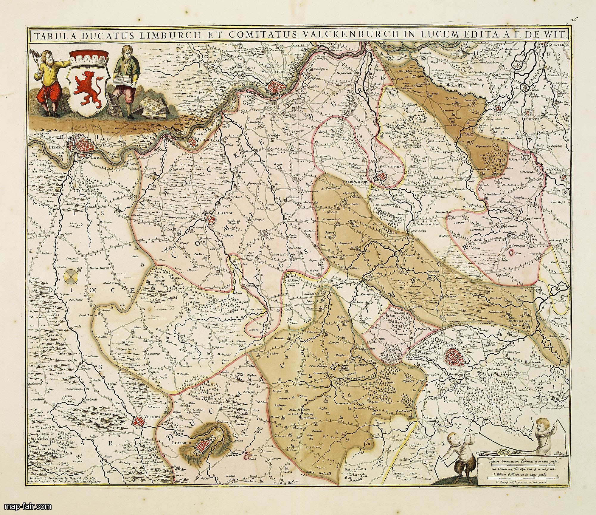
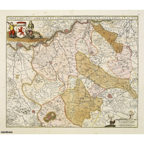
Tabula ducatus Limburch et comitatus Valckenburch. . .
BuyNow for $350
- Maker :
- DE WIT, F.
- Place :
- Amsterdam
- Date :
- 1690
- Color :
- In original colors.
- Height mm.:
- 470
- Width mm.:
- 559
- Condition :
- Printed on heavy paper. Backed with tissue paper for protective reason. In good condition.
- Bibliography :
- -
- Seller's ref. :
- 14345
This item is offered by Paulus_Swaen_Old_Maps
See other Items from this seller- Postage
-
Europe
$34 to France
- Select Country
- Zip/Post Code
- Quantity
$350
Description
The map describes the southern part of Limburg and reaches into Belgium (Liége, Verviers) and Germany. With two very decorative cartouches.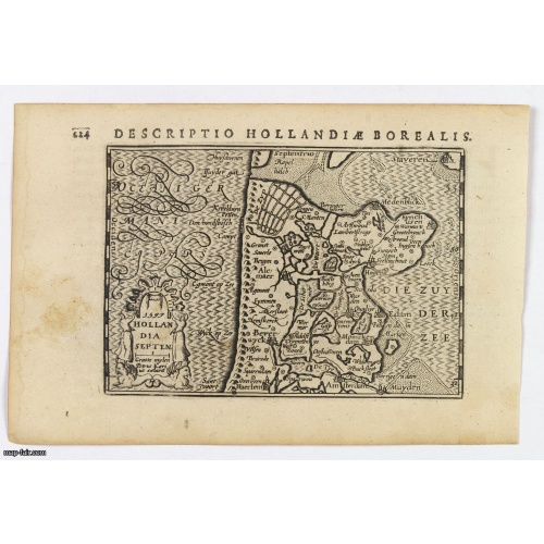
Hollandia Septentrionalis.
An attractive miniature map of the north Holland, northwards from Amsterdam to the Zijpe polder, published by Petrus Bertius, in Amsterdam at the beginning of the seventeenth century. It features a decorative title, sea hatching, elaborate cursive script, dykes and polders, some towns etc.This example is from the Tabularum Geographicarum Contractarum. Bertius (1565-1629) was a Flemish cartographer, theologian, historian and geographer. Although he published much in the fields of history, theolog...
$150
Maker : LANGENES, B. / BERTIUS, P.
Place : Amsterdam
Date : 1606
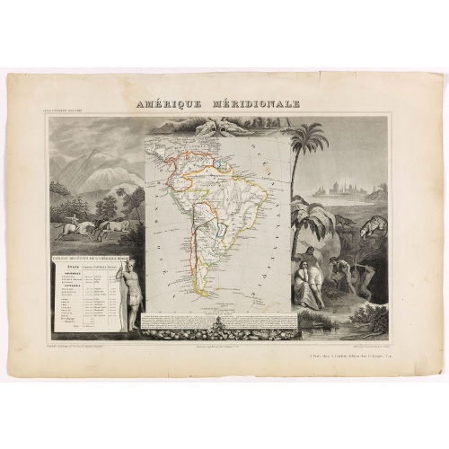
Amérique Méridionale.
Map of South America.Lovely map from one of the last decorative atlases of the nineteenth century.The rather simple map is framed by horses, Indians, jaguars, tapirs, and mining, as well as personifications of the rivers Amazon and La Plata at the top of the map. Victor Levasseur's "Atlas National Illustré" and "Atlas Universel Illustré" are among the last great decorative atlases published. This map comes from the Atlas National Illustré.
$90
Maker : LEVASSEUR, V.
Place : Paris, A. Combette
Date : 1852
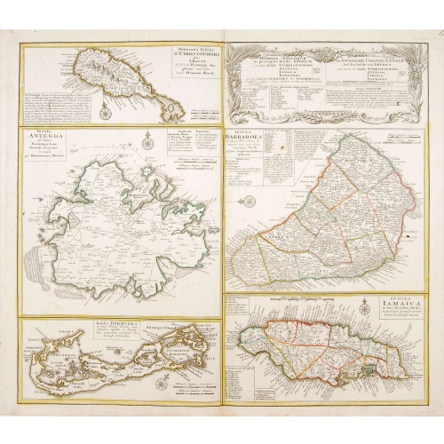
Dominia Anglorum in praecipuis Insulis Americae ut sunt Insula S. Christopheri, Antegoa, Iamaica, Barbados nec non Insula Bermudes vel Sommers . . .
Four maps of the islands of West Indies (St. Christoph "Delineatio Insulae St, Christophori alias I. Kitts", Antigua "Insula Antegoa", Barbados "Insula Barbadoes" and Iamaica "Insula Iamaica") and a map of Bermudas ("Insulae Bermudes") showing British possessions in the Caribbean. At the upper right of the sheet text in German relating to the areas depicted.A second edition with Bermudes. The first edition uses the name Bermudos.
$500
Maker : HOMANN HEIRS.
Place : Nuremberg
Date : 1740
-500x500.jpg)
Etats-Unis de l'Amérique du nord.
Detailed map of North America, prepared by Charles V. Monin (fl.1830-1880) a French cartographer of Caen and Paris. Published in Atlas Universel de Géographie Ancienne &c Moderne en 42 Cartes dressé par C.V. Monin. Engraved by Laguillermie.
$75
Maker : MONIN, C.V.
Place : Paris
Date : 1845
Postage & Shipping
-
Item Location
Terms and conditions - Item Location
- 75013, Ile-de-France, France
- Ships To
- United States, United Kingdom, Albania, Argentina, Armenia, Australia, Azerbaijan, Bahamas, Belgium, Bermuda, Cambodia, Canada, Chile, China, Croatia, Cyprus, Czech Republic, Denmark, Estonia, Finland, France, Germany, Gibraltar, Greece, Greenland, Guatemala, Hong Kong, Iceland, India, Indonesia, Israel, Italy, Japan, Latvia, Lithuania, Luxembourg, Malta, Mexico, Monaco, Netherlands, Norway, Singapore, Spain, Sweden, Switzerland, Turkey
- Pick-ups
- Buyer can pick-up
This item is owned and offered by the seller Paulus_Swaen_Old_Maps - All items are available for immediate sale, offered subject to prior sale.
Invoices are created by the seller by using our shopping cart or be prepared by the seller the day following the order and are emailed to you.
Items offeres by different sellers are invoiced separately.
Shipping fees are extra. The buyer is responsible for all applicable taxes, including any VAT, customs clearance, import duties, or equivalent costs arriving at the customer's home border. Payment is due on receipt of the invoice. The item(s) are shipped as soon as possible after receipt of your payment.
Before buying please read the complete Terms Conditions of Sale.
- Payment Methods
- Payment Simulator, Visa, Mastercard, Bank Transfer, PayPal
- Returns Accepted
- Yes
Post Message
Feel free to ask the seller a question. Please note that the seller could be located in an area with a different time zone. Our seller will do their best to respond within 24 hours.Post your message below.
Sign in to ask the seller a question.