ID: 83
Open
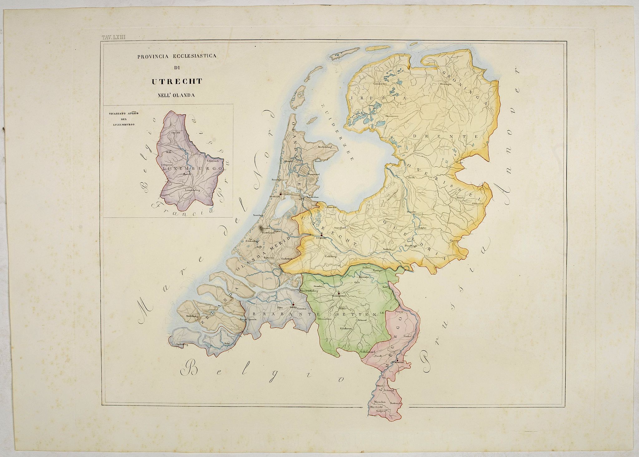
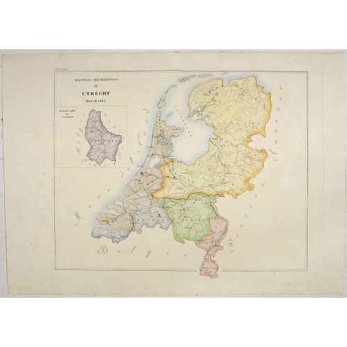
Provincia ecclesiastica di Utrecht Nell' Olanda (Tav LXIII)
BuyNow for $300
- Maker :
- PETRI Girolamo
- Place :
- Rome
- Date :
- 1858
- Color :
- In original color
- Height mm.:
- 485
- Width mm.:
- 593
- Condition :
- With original full hand color, on fine wove paper watermarked ‘Pietro Miliani Fabriano’, size of the sheet 570 x 800 mm.
- Bibliography :
- -
- Seller's ref. :
- 44104
This item is offered by Paulus_Swaen_Old_Maps
See other Items from this seller- Postage
-
Europe
$35 to France
- Select Country
- Zip/Post Code
- Quantity
$300
Description
This large-format map of The Netherlands with its different dioceses. The map is finely engraved and beautifully colored and was prepared by Girolamo Petri, a lawyer who served as a senior official within the Vatican’s State Secretariat, the arm of the Holy See responsible for managing its relationships with foreign powers.The map shows the various dioceses, which are each distinguished by their own bright colors, marking their seats, as well as other major towns. While key geographical features are expressed throughout, the map is otherwise intentionally rather sparing of detail, so as not to visually detract from their purpose, which is the show the ecclesiastical divisions.
The uncommonly beautiful map was published in only a very small number of examples for the exclusive use of Cardinals and high-ranking administrators, accounting for the great rarity today.
Petri was commissioned by Pope Pius XI (reigned 1846-78), the longest-ever reigning pontiff, to create an atlas during a time when the Church was under siege within Europe, but, conversely, while it had major ambitions for expansion overseas, particularity in Asia and Africa.
Girolamo Petri (1806 - 1871) was an important figure in the administration of the Roman Catholic Church during the reign of Pius IX. Petri was a great enthusiast of cartography, and it was only fitting that Pius IX charged him with creating the magnificent atlas, L’Orbe Cattolico.
In creating the atlas, Petri noted that he drew only upon the “most trusted sources”, including maps from the Vatican archives and overseas dioceses. The atlas was by far and away the finest ecclesiastical atlas created during the 19th Century, featuring exceptionally beautiful examples of thematic cartography.
Read more about Girolamo Petri. [+]
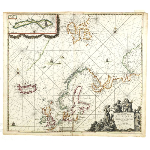
Pascarte van Europa Beginnende vande Canael tot aen Spitbergen, en van Ysland tot aen Nova Zemla . . .
An eye-catching chart of northern Europe with a coastline from northern Russia to the Dutch English Channel in the south. Good detail on Iceland. North to the top.In the upper left corner an inset map of Spitzbergen. Illuminated manuscripts had often been produced in pen and wash with a very limited color range, and many artists such as Jean Pucelle and Matthew Paris specialized in such work, which had been especially common in England since Anglo-Saxon times.Renaissance artists such as Mantegna...
$3.750
Maker : VAN KEULEN, J.
Place : Amsterdam
Date : after 1666

Nieuwe Wassende Graadige Pas-kaart van de Kust van Guinea en Brasilia.
Rare two-sheet sea chart of the coasts of Brazil, West Africa and South Africa, published by Johannes Van Keulen (the younger), circa 1720.The chart shows the western coast of Africa but the information provided in the map for Inland territories is wide. The South American coast of Brazil, the latter with a large, decorative, dedication cartouche inland, and Guyana. In the left-hand part a large dedicational cartouche to Abraham Anias, with the signature of Johannes van Keulen.Abraham Anias (169...
$2.250
Maker : VAN KEULEN, G.
Place : Amsterdam
Date : 1751
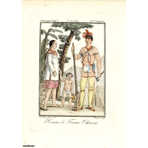
Homme & Femme Ottawas.
Hand-colored mezzotint of Native Americans engraved by Félix Mixelle and Lachaussée Jeune after Jacques Grasset de Saint-Sauveur.As an etcher, drawer and writer, Grasset de Saint-Sauveur was a prolific polygraph in keeping with the encyclopedic spirit of the eighteenth century: he wrote exotic novels as well as documentary works on various subjects. Called by one of his biographers a drawer without genius but a good example of the taste of his time, Grasset de Saint-Sauveur was literally bewit...
$75
Maker : GRASSET DE SAINT SAUVEUR,J.
Place : Paris,
Date : 1806
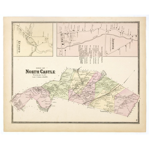
Town of North Castle.
Fine lithographed map of the town of North Castle. The map provides the names of specific homeowners, as well as information about the occupations and physical locations of the various tradesmen in each village from Beer's famous county atlas "Atlas of New York and vicinity, a documentary record of nineteenth-century life and delightful specimens of American folk art." F. W. Beers, along with other members of his family, were among the leading county atlas publishers in the period immediately fo...
$90
Maker : DE BEERS, F.W.
Place : New York
Date : 1867
Postage & Shipping
-
Item Location
Terms and conditions - Item Location
- 75013, Ile-de-France, France
- Ships To
- United States, United Kingdom, Albania, Argentina, Armenia, Australia, Azerbaijan, Bahamas, Belgium, Bermuda, Cambodia, Canada, Chile, China, Croatia, Cyprus, Czech Republic, Denmark, Estonia, Finland, France, Germany, Gibraltar, Greece, Greenland, Guatemala, Hong Kong, Iceland, India, Indonesia, Israel, Italy, Japan, Latvia, Lithuania, Luxembourg, Malta, Mexico, Monaco, Netherlands, Norway, Singapore, Spain, Sweden, Switzerland, Turkey
- Pick-ups
- No pick-ups
This item is owned and offered by the seller Paulus_Swaen_Old_Maps - All items are available for immediate sale, offered subject to prior sale.
Invoices are created by the seller by using our shopping cart or be prepared by the seller the day following the order and are emailed to you.
Items offeres by different sellers are invoiced separately.
Shipping fees are extra. The buyer is responsible for all applicable taxes, including any VAT, customs clearance, import duties, or equivalent costs arriving at the customer's home border. Payment is due on receipt of the invoice. The item(s) are shipped as soon as possible after receipt of your payment.
Before buying please read the complete Terms Conditions of Sale.
- Payment Methods
- Visa, Mastercard, Bank Transfer, American Express, iDEAL, PayPal, Google Pay
- Returns Accepted
- No
Post Message
Feel free to ask the seller a question. Please note that the seller could be located in an area with a different time zone. Our seller will do their best to respond within 24 hours.Post your message below.
Sign in to ask the seller a question.