ID: 99
Open

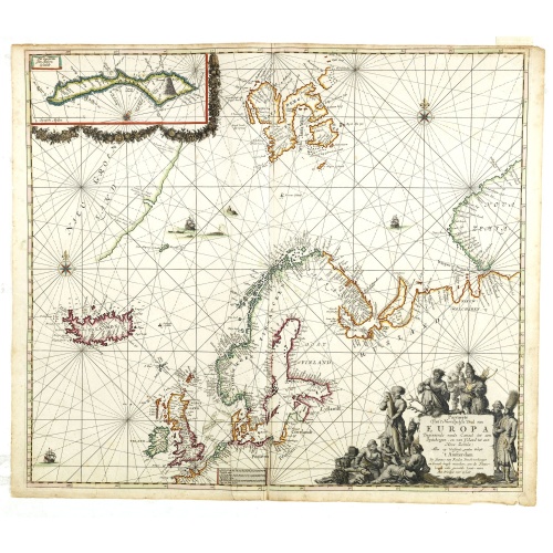
Pascarte van Europa Beginnende vande Canael tot aen Spitbergen, en van Ysland tot aen Nova Zemla . . .
BuyNow for $3.750
- Maker :
- VAN KEULEN, J.
- Place :
- Amsterdam
- Date :
- after 1666
- Color :
- In attractive original colors.
- Height mm.:
- 519
- Width mm.:
- 586
- Condition :
- In very fine condition. A good and dark impression. Some wrinkles next to the center fold. Cartouche, town spots are lavishly heightened with gold and figures in title cartouche colored in grisaille. Margins very mildly browned.
- Bibliography :
- -
- Seller's ref. :
- 34766
This item is offered by Paulus_Swaen_Old_Maps
See other Items from this seller- Postage
-
Standard Shipping
$0 to Netherlands
- Select Country
- Zip/Post Code
- Quantity
$3.750
Description
An eye-catching chart of northern Europe with a coastline from northern Russia to the Dutch English Channel in the south. Good detail on Iceland. North to the top.In the upper left corner an inset map of Spitzbergen.
Illuminated manuscripts had often been produced in pen and wash with a very limited color range, and many artists such as Jean Pucelle and Matthew Paris specialized in such work, which had been especially common in England since Anglo-Saxon times.
Renaissance artists such as Mantegna and Polidoro da Caravaggio often used grisaille as a classicizing effect, either in imitation of the effect of a classical sculptured relief, or of Roman painting.
In the Low Countries a continuous tradition of grisaille paintings can be traced from Early Netherlands painting to Martin Heemskerck, Pieter Brueghel the Elder, Hendrik Goltzius, the circle of Rembrandt, and Jan van Goyen.
Only a very limited number of map colored in grisaille are known.
The map is in a strictly contemporary coloring and of the highest level.

Marine parallel rulers in brass.
Very fine marine parallel rulers in brass. The parallel ruler is the oldest and most traditional way to measure and trace routes and bearings. The principle is simple: the ruler is placed on the road to be measured and then, like a pantograph, the other part of the ruler is placed on one of the declination roses on the map to determine the angle. They are, essentially, two straight-edges hinged so that they maintain the same angle. By alternating the moving edge, and securely holding down the no...
$1.500
Maker : ANONYMOUS
Place : Paris
Date : ca. 1880
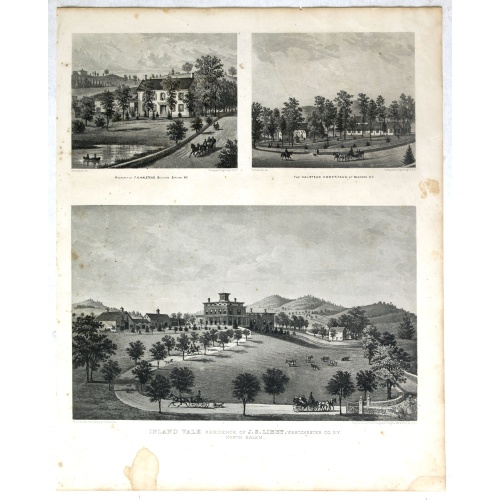
Property of F.A.Halstead Bedford Station, The Halstead Homestead at Bedford and Inland Vale residence of J.S.Libby, Westchester Co. NY North Salem.
Three heliographic prints on one sheet : "Property of F.A.Halstead Bedford Station", "The Halstead Homestead at Bedford" and "Inland Vale residence of J.S.Libby, Westchester Co. NY North Salem" after design by R.K.Sneden.From Beer's famous county atlas "Atlas of New York and vicinity, a documentary record of nineteenth century life and delightful specimens of American folk art". F. W. Beers, along with other members of his family, were among the leading county atlas publishers in period immediat...
$90
Maker : DE BEERS, F.W.
Place : New York
Date : 1867

A new mape of Ye XVII Provinces of Low Germanie.
Showing all 17 Provinces of the Netherlands before the split between Spain and the Protestant Provinces under the House of Orange.The map was first published. At the same time, the war of independence was still being fought against Philip II. With columns of figures on either side and surmounted by eight city prospects. A famous and most decorative item.A fourth state published by Thomas Basset and Richard Chiswell. The date has been removed and Speed's name has been added to the title cartouche...
$2.300
Maker : SPEED, J.
Place : London, 1676
Date : 1626
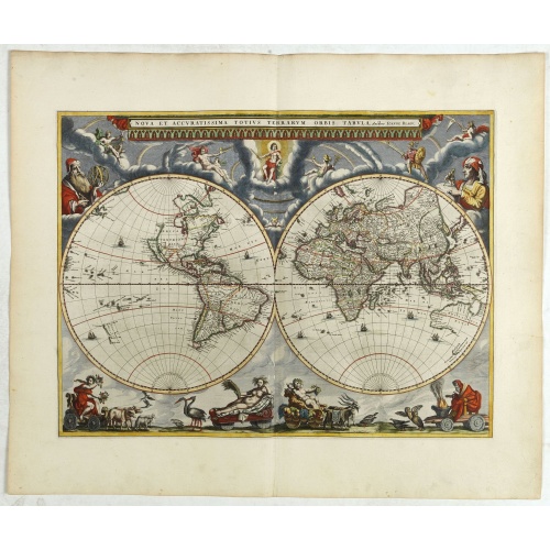
Nova et Accuratissima Totius Terrarum Orbis Tabula.
From his atlas Major.
$17.500
Maker : BLAEU, J.
Place : Amsterdam
Date : 1662
Postage & Shipping
-
Item Location
Terms and conditions - Item Location
- 75013, Ile-de-France, France
- Ships To
- United States, United Kingdom, Albania, Argentina, Armenia, Australia, Azerbaijan, Bahamas, Belgium, Bermuda, Cambodia, Canada, Chile, China, Croatia, Cyprus, Czech Republic, Denmark, Estonia, Finland, France, Germany, Gibraltar, Greece, Greenland, Guatemala, Hong Kong, Iceland, India, Indonesia, Israel, Italy, Japan, Latvia, Lithuania, Luxembourg, Malta, Mexico, Monaco, Netherlands, Norway, Singapore, Spain, Sweden, Switzerland, Turkey
- Pick-ups
- No pick-ups
This item is owned and offered by the seller Paulus_Swaen_Old_Maps - All items are available for immediate sale, offered subject to prior sale.
Invoices are created by the seller by using our shopping cart or be prepared by the seller the day following the order and are emailed to you.
Items offeres by different sellers are invoiced separately.
Shipping fees are extra. The buyer is responsible for all applicable taxes, including any VAT, customs clearance, import duties, or equivalent costs arriving at the customer's home border. Payment is due on receipt of the invoice. The item(s) are shipped as soon as possible after receipt of your payment.
Before buying please read the complete Terms Conditions of Sale.
- Payment Methods
- Visa, Mastercard, Bank Transfer, iDEAL, PayPal, Google Pay
- Returns Accepted
- No
Post Message
Feel free to ask the seller a question. Please note that the seller could be located in an area with a different time zone. Our seller will do their best to respond within 24 hours.Post your message below.
Sign in to ask the seller a question.