ID: 233
Open
Listing ID: #233 has been added to your wishlist.
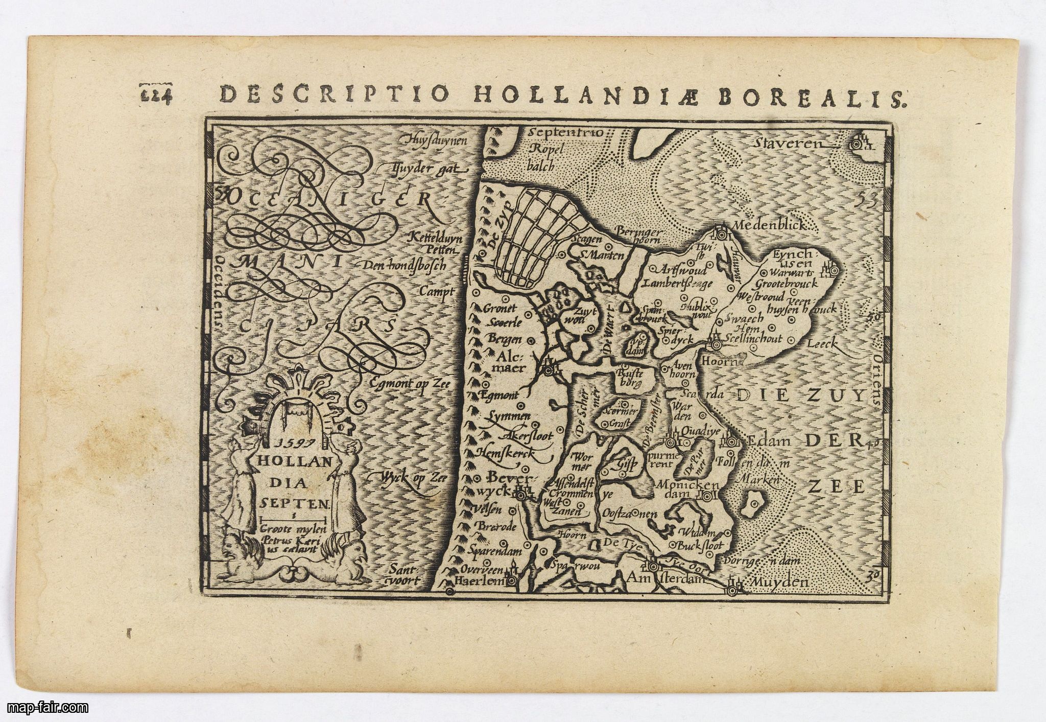
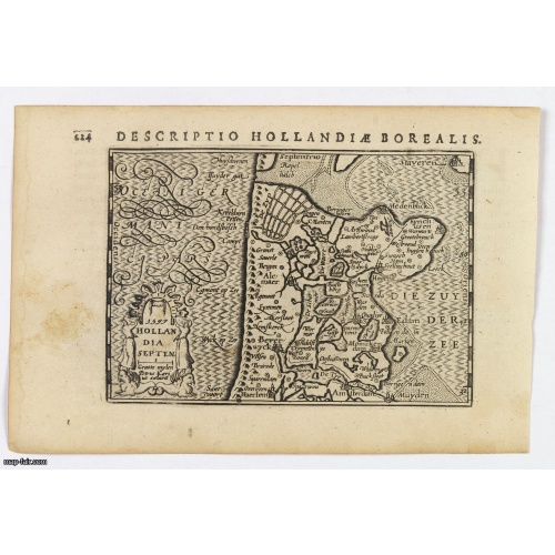
Hollandia Septentrionalis.
BuyNow for $150
- Maker :
- LANGENES, B. / BERTIUS, P.
- Place :
- Amsterdam
- Date :
- 1606
- Color :
- Uncoloured
- Height mm.:
- 85
- Width mm.:
- 123
- Condition :
- In very good condition, lightly age toned, water stain and marks, wide margins, dark impression. Latin text to verso. Some show through of verso text.
- Bibliography :
- -
- Seller's ref. :
- 43232
This item is offered by Paulus_Swaen_Old_Maps
See other Items from this seller- Postage
-
Europe
$34 to France
- Select Country
- Zip/Post Code
- Quantity
$150
Description
An attractive miniature map of the north Holland, northwards from Amsterdam to the Zijpe polder, published by Petrus Bertius, in Amsterdam at the beginning of the seventeenth century.It features a decorative title, sea hatching, elaborate cursive script, dykes and polders, some towns etc.
This example is from the Tabularum Geographicarum Contractarum.
Bertius (1565-1629) was a Flemish cartographer, theologian, historian and geographer. Although he published much in the fields of history, theology and mathematics, he is perhaps best known as a cartographer. His works were heavily influenced by the earlier works of Mercator, which date from the late sixteenth century. He was connected by marriage to Jacobus Hondius and Pieter van den Keere, both excellent cartographers, who would influence his later life. He was ‘Cosmographer’ to the court of King Louis XIII.
![[Dutch attack the fortress of Praia.]](/uploads/cache/39901-500x500.jpg)
[Dutch attack the fortress of Praia.]
Scarce print with German text sheet showing the Dutch attack on Praia.On 27th June 1589, Simon de Cordes left Holland with five ships, bound for the Magellan Straits. On reaching Santiago - one of the Cape Verde Islands, they decided to loot the fortress at Praia. This stood on top of a high rock whose only approach was by a narrow stairway with 175 steps. At the time the fortress was occupied by the Portuguese, under a Spanish commander. On landing, however, the Dutch were entertained by some o...
$80
Maker : GOTTFRIED, J.L. / DE BRY.
Place : Frankfurt, M.Merian, 1633
Date : 1633

Marine parallel rulers in brass.
Very fine marine parallel rulers in brass. The parallel ruler is the oldest and most traditional way to measure and trace routes and bearings. The principle is simple: the ruler is placed on the road to be measured and then, like a pantograph, the other part of the ruler is placed on one of the declination roses on the map to determine the angle. They are, essentially, two straight-edges hinged so that they maintain the same angle. By alternating the moving edge, and securely holding down the no...
$1.500
Maker : ANONYMOUS
Place : Paris
Date : ca. 1880
![Westelijk Halfrond. [Western hemisphere]](/uploads/cache/25524-500x500.jpg)
Westelijk Halfrond. [Western hemisphere]
Uncommon world map view of the western and eastern hemispheres of North and South America, Asia. Lithography by J.H. van Weijer, published in Atlas der geheele Aarde in 24 kaarten.
$50
Maker : SCHOLTENS, A.L.
Place : Groningen
Date : ca. 1860
Nader prolongatie van het Octroy voor de Westindische Compagnie voor den tyd van nog dertig jaaren. . .
A proclamation by the Dutch States General, dated 1761, extending the charter of the Dutch West India Company for another thirty years. Like the 1730 proclamation, it has detailed information about the import of slaves from West Africa to Surinam, Essequibo and Berbice, where the WIC was granted a monopoly in the slave trade, while others could import slaves to Curaçao and other parts of America, as the proclamation notes.
$1.500
Maker : SCHELTUS, I.
Place : Amsterdam
Date : 1761
Postage & Shipping
-
Item Location
Terms and conditions - Item Location
- Paris, Ile-de-France, France
- Ships To
- United States, United Kingdom, Albania, Argentina, Armenia, Australia, Azerbaijan, Bahamas, Belgium, Bermuda, Cambodia, Canada, Chile, China, Croatia, Cyprus, Czech Republic, Denmark, Estonia, Finland, France, Germany, Gibraltar, Greece, Greenland, Guatemala, Hong Kong, Iceland, India, Indonesia, Israel, Italy, Japan, Latvia, Lithuania, Luxembourg, Malta, Mexico, Monaco, Netherlands, Norway, Singapore, Spain, Sweden, Switzerland, Turkey
- Pick-ups
- No pick-ups
This item is owned and offered by the seller Paulus_Swaen_Old_Maps - All items are available for immediate sale, offered subject to prior sale.
Invoices are created by the seller by using our shopping cart or be prepared by the seller the day following the order and are emailed to you.
Items offeres by different sellers are invoiced separately.
Shipping fees are extra. The buyer is responsible for all applicable taxes, including any VAT, customs clearance, import duties, or equivalent costs arriving at the customer's home border. Payment is due on receipt of the invoice. The item(s) are shipped as soon as possible after receipt of your payment.
Before buying please read the complete Terms Conditions of Sale.
- Payment Methods
- Visa, Mastercard, Bank Transfer, iDEAL, PayPal
- Returns Accepted
- No
Post Message
Feel free to ask the seller a question. Please note that the seller could be located in an area with a different time zone. Our seller will do their best to respond within 24 hours.Post your message below.
Sign in to ask the seller a question.