
ID: 409
Open
Listing ID: #409 has been added to your wishlist.
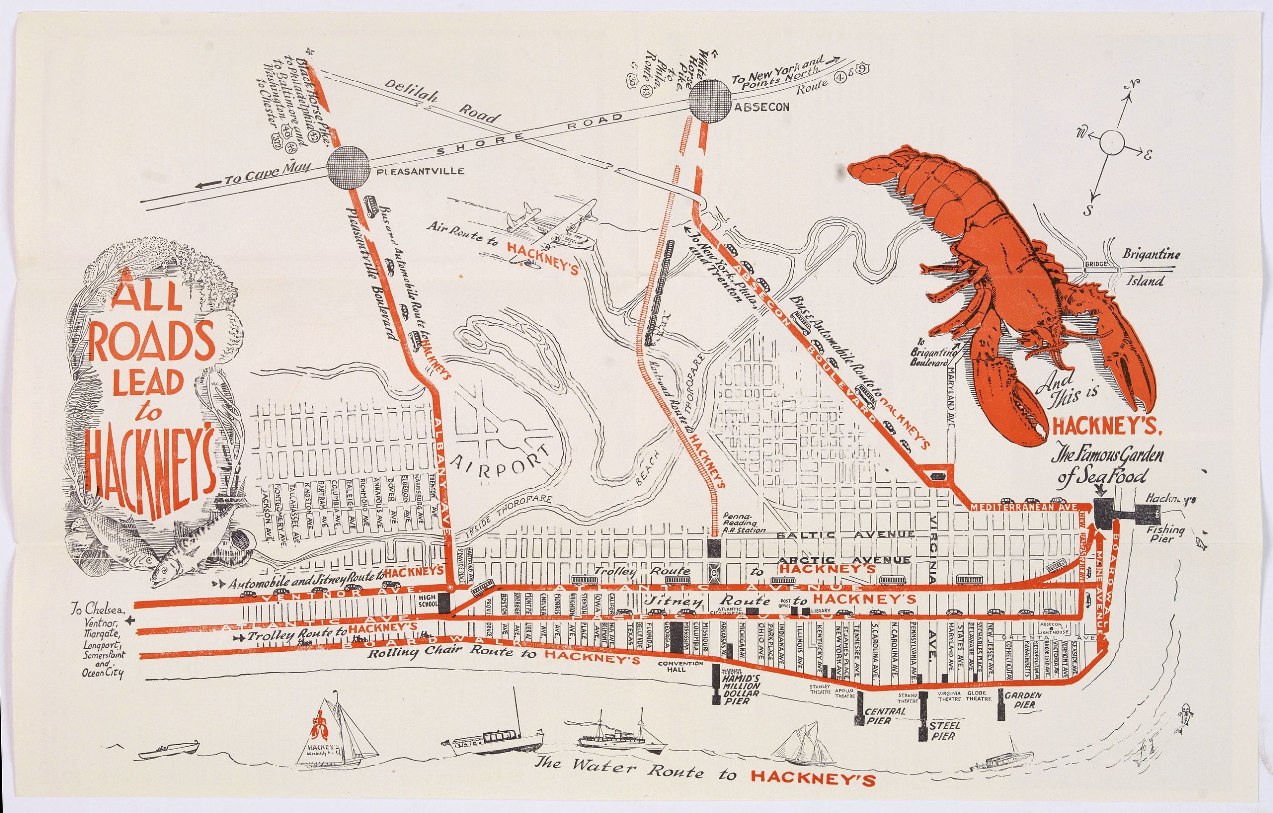
Map of Atlantic City to Hackney's Famous Garden of Sea Food . . .
BuyNow for €50
- Maker :
- ANONYMOUS.
- Place :
- New Jersey
- Date :
- 1954
- Color :
- Printed colors
- Height mm.:
- 255
- Width mm.:
- 395
- Condition :
- In very good condition. Multifolds as issued. Good margins.
- Bibliography :
- -
- Seller's ref. :
- 48434
This item is offered by Librairie_Loeb-Larocque
See other Items from this seller- Postage
-
France
€15 to France
- Select Country
- Zip/Post Code
- Quantity
€50
Description
A mid 1950s brochure for the famous Atlantic City Seafood Restaurant - 'Hackneys'. One side proclaims that "All Roads lead to Hackney's". It shows a nice plan of Atlantic City in NJ. Highlighted in red are the famous Boardwalk, Pacific, Atlantic, Albany and Mediterranean Avenues plus Absecon Boulevard, and all roads that lead off them.Other major thoroughfares and roads are shown, together with the Airport and bus and car route. Famous piers are in bold, plus there are small illustrations of sea craft - all heading to Hackney's!! With a compass and large illustration of a lobster.
On the verso are columns and panels of Hackney's related information, a street directory, two photographs, Hackney's Sea Food products and a map demonstrating the way to Atlantic City from NYC, Philadelphia, Wilmington and Cape May.
A wonderfully historic brochure of nostalgia.
-500x500.jpg)
INTERIEUR DE L'EGLISE SAINT OUEN A ROUEN. Dessiné d'après nature par Chapuy. Lith. Par Arnout. Fig par Bayot.
Original lithograph of the inside of Saint Ouen chruch, situated in Rouen. Lithographed by Arnout and Adolphe-Jean-Baptist Bayot (Alessandria 1810 - 1866) after a design by Chapuy and printed in Paris by Lemercier, Bernard Cie.
€50
Maker : CHAPUY
Place : Paris
Date : 1844

(Clermont, Brioude, Le Puy, etc.)
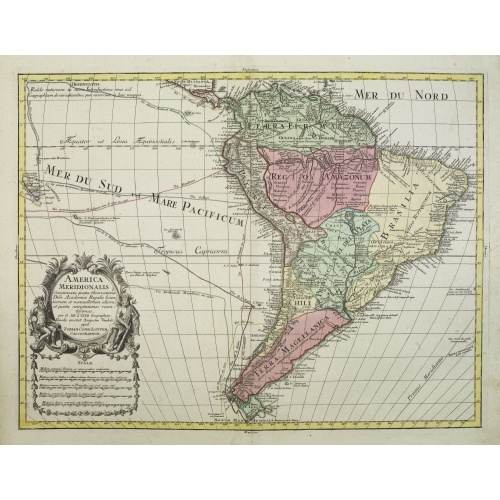
Rare miniature map including the towns of Clermont, Brioude, Le Puy, etc. From "Le theatre De Bellone, Contenant 48. nouvelles Cartes Geographiques, Des Païs-Bas Espagnols, Provinces-Unies, haute & basse Allemagne. . .". This rare atlas contained maps relating to the War of Spanish Succession. Published in Amsterdam by the widow of P. Schenk.
€60
Maker : SCHENK, P.
Place : Amsterdam
Date : 1710

Comparse des Cinq Quadrilles dans l'Amphitheatre.
An early and intriguing engraving recording one of the most celebrated and spectacular festivals held at Paris by the young Louis XIV. The multi-day tournament took place in front of the Tuileries, in a huge area today known as the Place de Carrousel. Groups of costumed noblemen representing "Romans" (lead by the French King), "Persians," "Turks," "Indians" and "Americans" participated in games of skill. This engraving was included as an illustration to a scarce work titled, "Courses de Testes e...
€550
Maker : SYLVESTRE, I.
Place : Paris, Imprimerie royale
Date : 1670

François.
A charming engraving of a French couple in 17th-century dress.Title in a curtain draped at top. French text on verso.From the original 1683 text edition of "Description d'Univers. . ." by Allain Manesson Mallet (1630-1706), a well travelled military engineer and geographer who worked in 17th century France under King Louis XIV.Published by Denys Thierry.
€50
Maker : MANESSON MALLET, A.
Place : Paris
Date : 1683
Postage & Shipping
-
Item Location
Terms and conditions - Item Location
- 75013, Ile-de-France, France
- Ships To
- United States, United Kingdom, Albania, Argentina, Armenia, Australia, Austria, Bahamas, Belgium, Bermuda, Bosnia and Herzegowina, Brazil, Bulgaria, Canada, Chile, China, Costa Rica, Denmark, Dominica, Egypt, El Salvador, Finland, France, Germany, Greece, Guatemala, Hong Kong, Hungary, Iceland, India, Italy, Japan, Korea (South), Kuwait, Liechtenstein, Lithuania, Luxembourg, Madagascar, Mexico, Monaco, Morocco, Netherlands, Netherlands Antilles, New Zealand, Norway, Paraguay, Peru, Philippines, Poland, Portugal, Qatar, Reunion, Romania, San Marino, Saudi Arabia, Seychelles, Singapore, Slovenia, South Africa, Spain, Sri Lanka, Suriname, Sweden, Switzerland, Taiwan, Thailand, Tunisia, Turkey, United Arab Emirates, Uruguay, Vietnam
- Pick-ups
- No pick-ups
This item is owned and offered by the seller Librairie_Loeb-Larocque - All items are available for immediate sale, offered subject to prior sale.
Invoices are created by the seller by using our shopping cart or be prepared by the seller the day following the order and are emailed to you.
Items offeres by different sellers are invoiced separately.
Shipping fees are extra. The buyer is responsible for all applicable taxes, including any VAT, customs clearance, import duties, or equivalent costs arriving at the customer's home border. Payment is due on receipt of the invoice. The item(s) are shipped as soon as possible after receipt of your payment.
Before buying please read the complete Terms Conditions of Sale.
- Payment Methods
- Visa, Mastercard, Bank Transfer, American Express, iDEAL, PayPal, Google Pay
- Returns Accepted
- No
Post Message
Feel free to ask the seller a question. Please note that the seller could be located in an area with a different time zone. Our seller will do their best to respond within 24 hours.Post your message below.
Sign in to ask the seller a question.

-500x500.jpg)
![In einem Todt. . . [ Chateau Chenonceaux ]](/uploads/cache/13817-500x500.jpg)