ID: 79
Closed
Listing ID: #79 has been added to your wishlist.
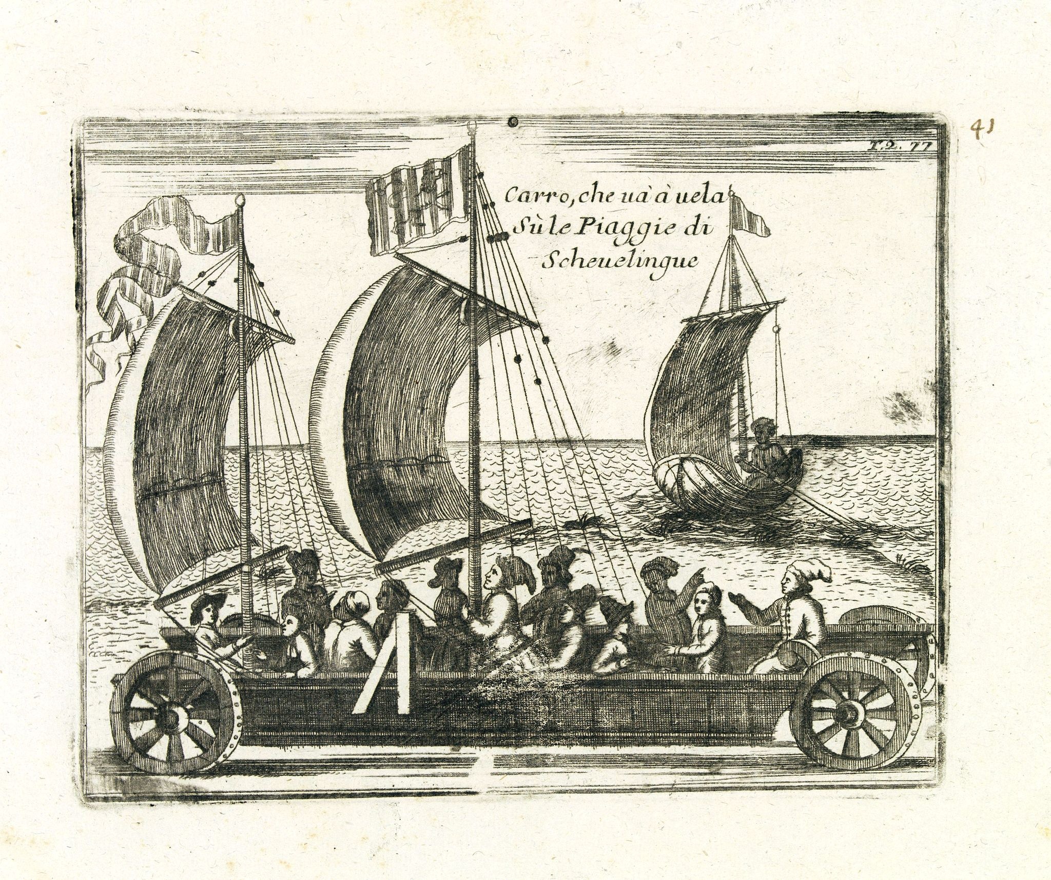
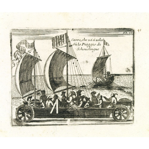
Carro, che uà à vela Su le Piagge di Schevelingue.
BuyNow for $225
- Maker :
- CORONELLI, V.
- Place :
- Venice
- Date :
- 1707
- Color :
- Uncoloured
- Height mm.:
- 135
- Width mm.:
- 170
- Condition :
- Good condition.
- Bibliography :
- -
- Seller's ref. :
- 33499
This item is offered by Paulus_Swaen_Old_Maps
See other Items from this seller- Postage
-
Europe
$34 to Netherlands
- Select Country
- Zip/Post Code
- Quantity
$225
Description
Italian version of Prince Maurits' sailing carriage designed by Simon Stevin. The big sailing-carriage could seat 28 persons and could reach a speed of seven miles per hour. The Prince often took his guests on a ride on the beaches of Scheveningen.
Marine parallel rulers in brass.
Very fine marine parallel rulers in brass. The parallel ruler is the oldest and most traditional way to measure and trace routes and bearings. The principle is simple: the ruler is placed on the road to be measured and then, like a pantograph, the other part of the ruler is placed on one of the declination roses on the map to determine the angle. They are, essentially, two straight-edges hinged so that they maintain the same angle. By alternating the moving edge, and securely holding down the no...
$1.500
Maker : ANONYMOUS
Place : Paris
Date : ca. 1880

Rotterdam
A bird's-eye view of the town. With extensive shipping in the foreground. From "Topographia Germaniae Inferioris". Matthäus Merian, the leading German illustrator of the 17th century, was born in Basel in 1593. He learned the art of copperplate engraving in Zurich and subsequently worked and studied in Strasbourg, Nancy, Paris, and the Low Countries. In 1618 he went to Frankfurt, wherein 1618 he marries the eldest daughter of J.T. de Bry, publisher and engraver. After de Bry died in 1623, he ...
$1.750
Maker : MERIAN, C.
Place : Frankfurt
Date : 1659

Zee caerte vande Sondt tvermaerste van Danemarcke . . .
A detailed chart of the coast of Denmark and its islands, Copenhagen in the center of the chart. West to the top. It is decorated by a title, scale and descriptive cartouche, a compass rose, several vessels and sea monsters, and depictions of mountains, fields, trees, small villages and animals.The chart shows soundings, sandbanks, landmarks and coastal profiles.Chart from an early Dutch text edition of this landmark contribution to the science of navigation. Waghenaer's own experiences as a pil...
$3.000
Maker : WAGHENAER, L. J.
Place : Leiden, Plantijn
Date : 1585

Belchrijuinghe vande zee custen van Engelandt. . .
A rare Dutch text edition of this detailed early chart of the northern coast of England. West to the top. The mileage cartouche has no Latin captures. Decorated by a colorful title cartouche and scale cartouche, one compass rose, and several vessels. An early Dutch text edition of this landmark contribution to the science of navigation. Waghenaer's own experiences as a pilot along European coasts were used to compile the Spiegel der Zeevaerdt, the first edition of which was published in Dutch at...
$3.000
Maker : WAGHENAER, L. J.
Place : Leiden, Plantijn
Date : 1585
Postage & Shipping
-
Item Location
Terms and conditions - Item Location
- Amsterdam, , Netherlands
- Ships To
- United States, United Kingdom, Albania, Argentina, Armenia, Australia, Azerbaijan, Bahamas, Belgium, Bermuda, Cambodia, Canada, Chile, China, Croatia, Cyprus, Czech Republic, Denmark, Estonia, Finland, France, Germany, Gibraltar, Greece, Greenland, Guatemala, Hong Kong, Iceland, India, Indonesia, Israel, Italy, Japan, Latvia, Lithuania, Luxembourg, Malta, Mexico, Monaco, Netherlands, Norway, Singapore, Spain, Sweden, Switzerland, Turkey
- Pick-ups
- No pick-ups
This item is owned and offered by the seller Paulus_Swaen_Old_Maps - All items are available for immediate sale, offered subject to prior sale.
Invoices are created by the seller by using our shopping cart or be prepared by the seller the day following the order and are emailed to you.
Items offeres by different sellers are invoiced separately.
Shipping fees are extra. The buyer is responsible for all applicable taxes, including any VAT, customs clearance, import duties, or equivalent costs arriving at the customer's home border. Payment is due on receipt of the invoice. The item(s) are shipped as soon as possible after receipt of your payment.
Before buying please read the complete Terms Conditions of Sale.
- Payment Methods
- Visa, Mastercard, Bank Transfer, American Express, iDEAL, PayPal, Google Pay
- Returns Accepted
- No
Post Message
Feel free to ask the seller a question. Please note that the seller could be located in an area with a different time zone. Our seller will do their best to respond within 24 hours.Post your message below.
Sign in to ask the seller a question.