

Paskaerte van het inkoomen van de MAES, Tot aen 't Eylandt Roosenburgh als mede 't Inkoomen van 't Goereesche Gat.. / Pascaert van 't Eylandt Roosenburg door de Oude en Nieuwe Maes....
A very attractive sea chart on two sheets of the mouth of the river Maas. The left sheet shows Dordrecht, Rotterdam and the fortress at Willemstad. Rghthand sheet depicts "Hook of Holland" showing Goeree and Brielle. Elaborate sea-themed cartouches and Poseidon vignette on the western sheet. Both scale cartouches decorated with cornucopia. Each include rhumb lines and a compass rose. Nicely detailed depths and banks. Set of 2 charts when joined 110 x 49 cm.- Paskaerte van het Inkoomen van de...
€1.500
Maker : KEULEN, J. van.
Place : Amsterdam
Date : 1680

Painting made by a sailor, signed W. Welman.
Painting made by a sailor, signed W.Welman.
€250
Maker : WELMAN, W.
Place : Unknown
Date : c.1960
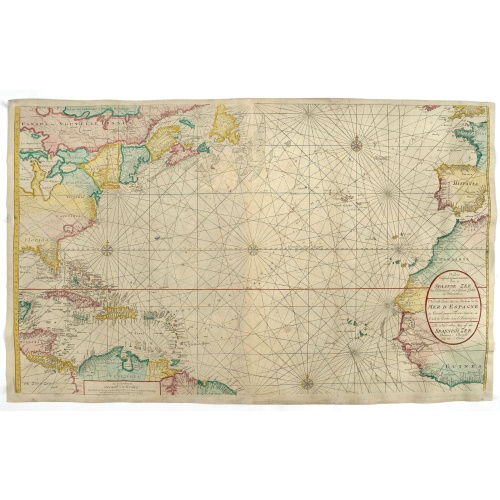
Nieuwe Wassende Graade Zee Kaart over de Spaanse Zee Vant Kanaal tot 't Eyland Cuba In Westindia.
Rare two-sheet blue-back sea chart of the Atlantic and Eastern part of North America., published by Gerard Van Keulen. The map extends from the latitude of Newfoundland and the English Channel in the north to the Equator in the south.In North America, most of the Great Lakes are shown and a large lake (Apalache Lac) in South Carolina. Florida is presented in a triangular shape.Florida is shown in a triangular model, with large islands forming the tip and numerous soundings along the coast. The ...
€2.500
Maker : VAN KEULEN, G.
Place : Amsterdam
Date : ca. 1728-1751
![[Original drawing: Fisher's ships on the beach of Scheveningen.]](/uploads/cache/86253-500x500.jpg)
[Original drawing: Fisher's ships on the beach of Scheveningen.]
Unique pencil drawing: Typical Dutch beach life with flat-bottomed ships on the beach of Scheveningen. Signed in the lower right corner and on the back site with P.A. Beretta (Petrus Augustus Beretta)
€450
Maker : BERETTA, Petrus Augustus Artist
Place : The Netherlands
Date : c. 1850
Original Maritime painting of the 'Cape Horn' , a so-called captain's ship drawing by R. Takes
A fine example of a so-called 'captain's portrait' of a clipper-ship under full sail. The name of the ship at the bow reads "Cape Horn" Signed in the lower right corner: R.Takes.
€750
Maker : TAKES, R.
Place : unknown
Date : c. 1850
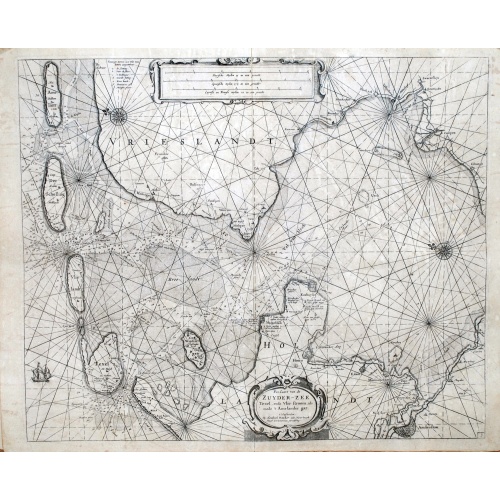
Pas-Caart van de ZUYDER-ZEE, Texel ende Vlie-stroom.als mede 't Amelander gat (Hollandt/Vrieslandt)
An attractive chart of the Zuiderzee, now the inland water het IJselmeer.HOLLANDT / VRIESLANDTPas-Caart van de Zuyder-Zee, Texel ende Vlie-stroom.als mede 't Amelander gat (1665)
€1.500
Maker : DONCKER, Hendrick
Place : Amsterdam
Date : c. 1665