
ID: 367
Open

Die Vereinigten Staaten von Nord Amerika..
BuyNow for €500
- Maker :
- MARIANUS, J.
- Place :
- Germany, 1790
- Date :
- 1790
- Color :
- Color printed
- Height mm.:
- 193
- Width mm.:
- 255
- Condition :
- Upper margin cut close. Good and dark impression.
- Bibliography :
- -
- Seller's ref. :
- 05981
This item is offered by Librairie_Loeb-Larocque
See other Items from this seller- Postage
-
France
€15 to France
- Select Country
- Zip/Post Code
- Quantity
€500
Description
Uncommon map of the east coast of North America, including the Great Lakes area. To the right inset map of New Foundland. After the map by William Faden of 1783. With color-key.
François.
A charming engraving of a French couple in 17th-century dress.Title in a curtain draped at top. French text on verso.From the original 1683 text edition of "Description d'Univers. . ." by Allain Manesson Mallet (1630-1706), a well travelled military engineer and geographer who worked in 17th century France under King Louis XIV.Published by Denys Thierry.
€50
Maker : MANESSON MALLET, A.
Place : Paris
Date : 1683
![Carte generale de France. [de l'Europe]](/uploads/cache/38442-500x500.jpg)
Carte generale de France. [de l'Europe]
A fine and uncommon early 17th century map of France printed from two copper plates. Engraved by Liébaux.From the French text edition of "Description d'Univers", 1683. by Allain Manneson Mallet (1630-1706), a well travelled military engineer and geographer who worked in 17th century France under King Louis XIV.
€80
Maker : MALLET, A.M.
Place : Paris
Date : 1683
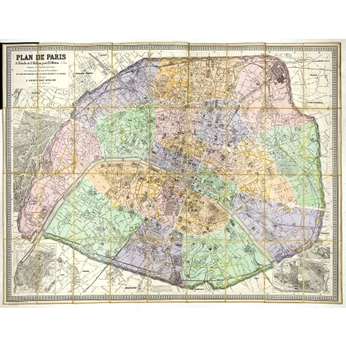
Plan de Paris A l'Echelle de 2 Millim. pour 2.5 Metres . . . Indiquant les Nouveaux percements et les changements de mons de Voies publiques Avec Plans Supplmentaries Pour Les Bois De Boulogne et De Vicennes . . .
Magnificent map of the urban redevelopments planned for Paris at the end of the 19th century. The map has been updated, with insets showing supplemental plans for the Bois de Boulogne and Vicennes neighborhoods.
€600
Maker : ANDRIVEAU-GOUJON, E.
Place : Paris
Date : 1878
![Cordelirs in Franckr. [France].](/uploads/cache/13799-500x500.jpg)
Cordelirs in Franckr. [France].
A very nice view of the town of Cordeliers. On the foreground, a man hunting a wolf is depicted. With a verse in German and Latin underneath the picture.The poet and topographer from Comothau, Daniel Meisner (1585-1625), started his first publication entitled Thesaurus Philo-Politicus in Frankfurt in 1623, initially in parts, each one containing about fifty plans. The work was engraved circa 1623-1650, and printed 1678, and was published by Eberhard Kieser. In 1678 the collection of copperplate...
€80
Maker : MEISNER, D.
Place : Frankfurt
Date : 1623-1678
Postage & Shipping
-
Item Location
Terms and conditions - Item Location
- 75013, Ile-de-France, France
- Ships To
- United States, United Kingdom, Albania, Argentina, Armenia, Australia, Austria, Bahamas, Belgium, Bermuda, Bosnia and Herzegowina, Brazil, Bulgaria, Canada, Chile, China, Costa Rica, Denmark, Dominica, Egypt, El Salvador, Finland, France, Germany, Greece, Guatemala, Hong Kong, Hungary, Iceland, India, Italy, Japan, Korea (South), Kuwait, Liechtenstein, Lithuania, Luxembourg, Madagascar, Mexico, Monaco, Morocco, Netherlands, Netherlands Antilles, New Zealand, Norway, Paraguay, Peru, Philippines, Poland, Portugal, Qatar, Reunion, Romania, San Marino, Saudi Arabia, Seychelles, Singapore, Slovenia, South Africa, Spain, Sri Lanka, Suriname, Sweden, Switzerland, Taiwan, Thailand, Tunisia, Turkey, United Arab Emirates, Uruguay, Vietnam
- Pick-ups
- No pick-ups
This item is owned and offered by the seller Librairie_Loeb-Larocque - All items are available for immediate sale, offered subject to prior sale.
Invoices are created by the seller by using our shopping cart or be prepared by the seller the day following the order and are emailed to you.
Items offeres by different sellers are invoiced separately.
Shipping fees are extra. The buyer is responsible for all applicable taxes, including any VAT, customs clearance, import duties, or equivalent costs arriving at the customer's home border. Payment is due on receipt of the invoice. The item(s) are shipped as soon as possible after receipt of your payment.
Before buying please read the complete Terms Conditions of Sale.
- Payment Methods
- Visa, Mastercard, Bank Transfer, American Express, iDEAL, PayPal, Google Pay
- Returns Accepted
- No
Post Message
Feel free to ask the seller a question. Please note that the seller could be located in an area with a different time zone. Our seller will do their best to respond within 24 hours.Post your message below.
Sign in to ask the seller a question.
