
ID: 389
Open
![[How the Inca nobility are buried] / [Bridge of Huaynacapaco]](/uploads/41094.jpg)
[How the Inca nobility are buried] / [Bridge of Huaynacapaco]
BuyNow for €80
- Maker :
- GOTTFRIED, J.L. / DE BRY.
- Place :
- Frankfurt, M.Merian
- Date :
- 1633
- Color :
- Uncoloured
- Height mm.:
- 160
- Width mm.:
- 185
- Condition :
- Copper plate engraving on text sheet. Paper lightly browned and stained, as is usual. A lower corner is missing, minor tears, repairs etc. Size of sheet: 345 x 222 mm. German text and on verso.
- Bibliography :
- -
- Seller's ref. :
- 41094
This item is offered by Librairie_Loeb-Larocque
See other Items from this seller- Postage
-
France
€15 to France
- Select Country
- Zip/Post Code
- Quantity
€80
Description
Two engravings. [470] The funeral of an Inca king was a ceremony of great splendor. After digging a large pit, the Indians would decorate the corpse with gold and silver then bury it with many fine ornaments, along with good food and wine to help it on its way into the next world. Benzoni so described the burial of Huayna-Capac, whose grave he said was on the border of the province of Quito. When the Spanish first went to Peru, they discovered and pillaged many such graves.[469] Much of Ecuador was ruled from Quito by the Inca king, Huayna-Capac. In order to quell the Indians on the other side of the River Chiouo (Guayas) they had to build a rope bridge at Huaynacapaco. While they were crossing it, though, the local Indians cut the bridge on both sides and most of Huayna-Capac’s men were drowned.
(There is a bridge with this name at Vilcabamba in Peru but Smyth’s edited version of Benzoni suggests the bridge crossed the Guayas.)
In 1631 Johann Ludwig Gottfried, inherited the Theodor De Bry’s publishing firm, among the illustrated accounts of the expeditions of Magellan, Columbus, Vespucci, Cortes, Balboa, Raleigh, Drake, Smith, and many others.
Gottfried issued together with Matthaeus Merian a one-volume condensation "Newe Welt Vnd Americanische Historien/ Jnhaltende Warhafftige vnd volkommene Beschreibungen Aller West-Jndianischen Landschafften..." that used many of the original copper plates and supplemented them with new ones of more recent voyages. The book was published by Matthaeus Merian. The work was reprinted in 1655 / 1657.
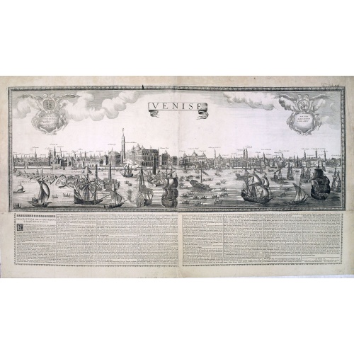
Venise. 1700
Extremely rare panoramic broad sheet panoramic town-view of Venice with underneath in letter press a description of the town's history.The view measures more than 1 meter. The foreground is animated with a great variety of sailing vessels.The printer's address is dated 1699, but the tile has the date 1700. Most likely, Jaillot published the view to celebrate the turn of the century!
€20.000
Maker : JAILLOT, H.
Place : Paris
Date : 1699
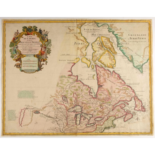
Carte du Canada ou de la Nouvelle France.
Fourth state of the map of Canada published by Delisle with the imprint "sur le Quai de l’Horloge a l’Aigle d’Or avec Privilege pour 20 ans, 1703". Beneath the title, Renard’s imprint is erased.Including the fictitious discoveries of Baron de Lahoutan: the legendary River Longue etc. The north west corner of Hudson Bay is left open, leaving the possibility of a north west passage open. De l'Isle's map was the first to show Detroit (founded by Cadillac) and the first to mention a settleme...
€500
Maker : DE L'ISLE, G.
Place : Paris
Date : 1703
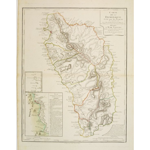
Carte de la Dominique Prise par les Francois le 7 Septembre 1778. Avec le Plan du Debarquement et de l'Attaque des Forts et Batteries par les Troupes et Les Fregates de sa Majeste
A rare map of St. Dominica, with insets of Charlotteville with its attack by the French on 7 September 1778 on the British. Also small inset map of the Caribbean islands from Antigua till Grenada. With dedication to de Sartine, a French official.
€500
Maker : BUACHE, S.
Place : Paris
Date : 1780

Plan du Port des Francais sur la Cote du Nord-Ouest de l'Amerique, par 58°37' de Latitude Nord et 139°50' de Longitude Occidentale, Decouverte le 2 Juillet 1786,...
Chart of the entrance of Bassin de L'Quest , visited on July 2nd 1786 by La Perouse. On many 18th century maps we find a depiction of Mer de L'Quest or Sea of the West a great sea, easily the size of the Mediterranean, to flow from the then-known Strait of Juan de Fuca and an opening to the ocean from this great sea at roughly in North California or Oregon and Quivira somewhere in Idaho.Engraved by Bouclet.
€500
Maker : LA PEROUSE, J.F.G.
Place : Paris
Date : 1798
Postage & Shipping
-
Item Location
Terms and conditions - Item Location
- 75013, Alsace, France
- Ships To
- United States, United Kingdom, Albania, Argentina, Armenia, Australia, Austria, Bahamas, Belgium, Bermuda, Bosnia and Herzegowina, Brazil, Bulgaria, Canada, Chile, China, Costa Rica, Denmark, Dominica, Egypt, El Salvador, Finland, France, Germany, Greece, Guatemala, Hong Kong, Hungary, Iceland, India, Italy, Japan, Korea (South), Kuwait, Liechtenstein, Lithuania, Luxembourg, Madagascar, Mexico, Monaco, Morocco, Netherlands, Netherlands Antilles, New Zealand, Norway, Paraguay, Peru, Philippines, Poland, Portugal, Qatar, Reunion, Romania, San Marino, Saudi Arabia, Seychelles, Singapore, Slovenia, South Africa, Spain, Sri Lanka, Suriname, Sweden, Switzerland, Taiwan, Thailand, Tunisia, Turkey, United Arab Emirates, Uruguay, Vietnam
- Pick-ups
- Buyer can pick-up
This item is owned and offered by the seller Librairie_Loeb-Larocque - All items are available for immediate sale, offered subject to prior sale.
Invoices are created by the seller by using our shopping cart or be prepared by the seller the day following the order and are emailed to you.
Items offeres by different sellers are invoiced separately.
Shipping fees are extra. The buyer is responsible for all applicable taxes, including any VAT, customs clearance, import duties, or equivalent costs arriving at the customer's home border. Payment is due on receipt of the invoice. The item(s) are shipped as soon as possible after receipt of your payment.
Before buying please read the complete Terms Conditions of Sale.
- Payment Methods
- Visa, Mastercard, Bank Transfer, American Express, iDEAL, PayPal, Google Pay
- Returns Accepted
- No
Post Message
Feel free to ask the seller a question. Please note that the seller could be located in an area with a different time zone. Our seller will do their best to respond within 24 hours.Post your message below.
Sign in to ask the seller a question.
![[How the Inca nobility are buried] / [Bridge of Huaynacapaco]](/uploads/cache/41094-500x500.jpg)