ID: 5
Open


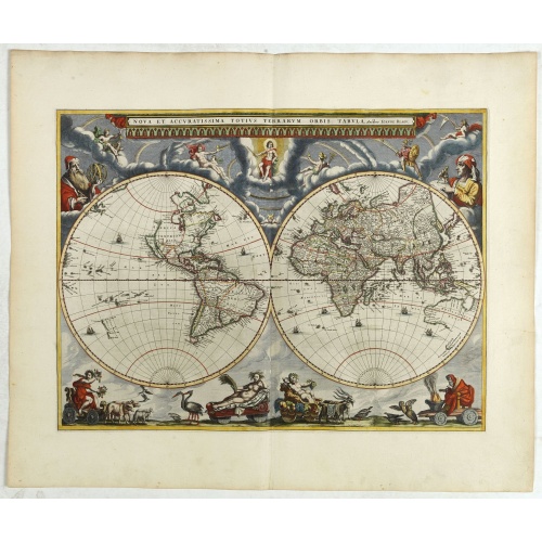
Nova et Accuratissima Totius Terrarum Orbis Tabula.
From his atlas Major.
BuyNow for $17.500
- Maker :
- BLAEU, J.
- Place :
- Amsterdam
- Date :
- 1662
- Color :
- In original colors
- Height mm.:
- 405
- Width mm.:
- 545
- Condition :
- Mint condition with very large margins. French text on verso.
- Bibliography :
- -
- Seller's ref. :
- 42850
This item is offered by Paulus_Swaen_Old_Maps
See other Items from this seller- Postage
-
Standard Shipping
$0 to France
- Select Country
- Zip/Post Code
- Quantity
$17.500
Description
Since its appearance as an Appendix in 1630, the atlas launched by
Willem Blaeu and continued by his son Joan had expanded greatly. But
despite many new regional maps the world map remained unchanged. For
some reason, Joan Blaeu's important wall map of 1648 was not immediately
adapted by his firm for atlas use.
The New
World map prepared by Joan Blaeu for his eleven-volume 'Atlas Maior' in
1662 is, unlike its predecessor, in two hemispheres. Outside the twin
hemispheres at the top are celestial figures seated amid clouds: below
are representations of the four seasons, with each allegorical figure
seated in an appropriate chariot quaintly drawn by pairs of beasts and
birds. As with all productions by the firm of Blaeu, the engraving and
layout and elegance of decoration are all of the highest standards.
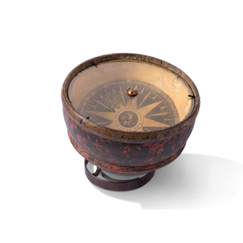
Mariner’s compass
Inverted compass called "snitch" in wood painted in imitation of tortoiseshell and brass, signed "Ing MANN Maker Water Street Liverpool".
$3.000
Maker : MANN
Place : Liverpool
Date : ca. 1785

A ship's hour glass.
Maritime hourglass with blown glass bulbs, orange sand, junction ring covered with cord, the circular ebony frame with six turned baluster columns.The invention of the hourglass is attributed to an 8th-century monk in Chartres, France, with the marine sandglass appearing as early as the 14th century. In earlier examples, the bulbs were connected with a material such as putty or hardened wax, bound in leather, linen or string. From about 1720, the two bulbs were welded together over a brass bead ...
$1.750
Maker : ANONYMOUS
Place : The Netherlands or Germany
Date : ca. 1750
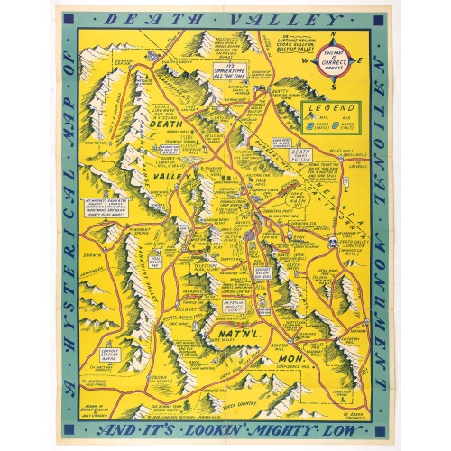
A Hysterical Map Of Death Valley National Monument -- And It's Looking Mighty Low
First edition Humorous map of Death Valley. "Drawn In Broken English by Jolly Lindgren," this comic pictorial map is full of puns and comic vignettes related to Death Valley. The Lindgren Brothers issued a number of other silly whimsical maps of national parks and other parts of the West.
$500
Maker : LINDGREN, J.
Place : Spokane, Wash., Lindgren Brothers,
Date : 1948

Pas-Caart van Hispangien vertoonde de Custen van Granade…
An eye-catching chart of Spain and Portugal, including a large part of Brittany and the southwestern coast of France, including Isle de Reé , Isle Saint Martin ...Pieter Goos (ca. 1616-1675) was one of the most important cartographers, engraver, publisher and print seller of Amsterdam. His widow continued business at her husband's death. She re-issued 'Nieuwe Groote Zee-Spiegel in 1676.The chart is in a strictly contemporary coloring and of the highest level.
$1.000
Maker : GOOS, P.
Place : Amsterdam
Date : 1669-1676
Postage & Shipping
-
Item Location
Terms and conditions - Item Location
- Amsterdam, , Netherlands
- Ships To
- United States, United Kingdom, Albania, Argentina, Armenia, Australia, Azerbaijan, Bahamas, Belgium, Bermuda, Cambodia, Canada, Chile, China, Croatia, Cyprus, Czech Republic, Denmark, Estonia, Finland, France, Germany, Gibraltar, Greece, Greenland, Guatemala, Hong Kong, Iceland, India, Indonesia, Israel, Italy, Japan, Latvia, Lithuania, Luxembourg, Malta, Mexico, Monaco, Netherlands, Norway, Singapore, Spain, Sweden, Switzerland, Turkey
- Pick-ups
- Buyer can pick-up
This item is owned and offered by the seller Paulus_Swaen_Old_Maps - All items are available for immediate sale, offered subject to prior sale.
Invoices are created by the seller by using our shopping cart or be prepared by the seller the day following the order and are emailed to you.
Items offeres by different sellers are invoiced separately.
Shipping fees are extra. The buyer is responsible for all applicable taxes, including any VAT, customs clearance, import duties, or equivalent costs arriving at the customer's home border. Payment is due on receipt of the invoice. The item(s) are shipped as soon as possible after receipt of your payment.
Before buying please read the complete Terms Conditions of Sale.
- Payment Methods
- Visa, Mastercard, Bank Transfer, American Express, iDEAL, PayPal, Google Pay
- Returns Accepted
- No
Post Message
Feel free to ask the seller a question. Please note that the seller could be located in an area with a different time zone. Our seller will do their best to respond within 24 hours.Post your message below.
Sign in to ask the seller a question.