
ID: 142
Open
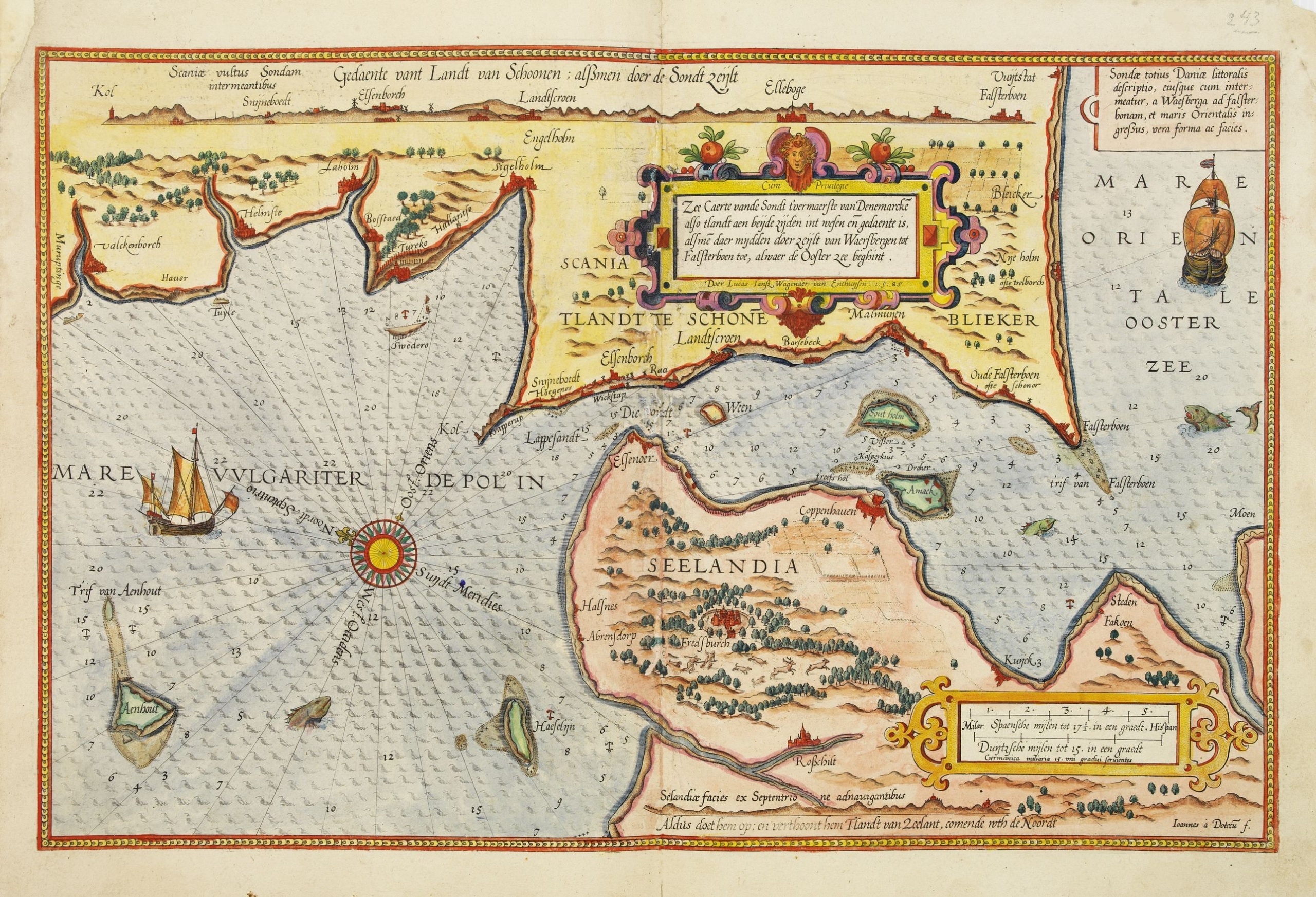
Zee caerte vande Sondt tvermaerste van Danemarcke . . .
BuyNow for $3.000
- Maker :
- WAGHENAER, L. J.
- Place :
- Leiden, Plantijn
- Date :
- 1585
- Color :
- Colored
- Height mm.:
- 325
- Width mm.:
- 510
- Condition :
- Paper slightly age-toned. Some re-enforcement wormholes along the center fold. Upper left marginal corner re-enforced. Else good condition.
- Bibliography :
- -
- Seller's ref. :
- 25457
This item is offered by Paulus_Swaen_Old_Maps
See other Items from this seller- Postage
-
Standard Shipping
$0 to France
- Select Country
- Zip/Post Code
- Quantity
$3.000
Description
A detailed chart of the coast of Denmark and its islands, Copenhagen in the center of the chart. West to the top. It is decorated by a title, scale and descriptive cartouche, a compass rose, several vessels and sea monsters, and depictions of mountains, fields, trees, small villages and animals.
The chart shows soundings, sandbanks, landmarks and coastal profiles.
Chart from an early Dutch text edition of this landmark contribution to the science of navigation.
Waghenaer's own experiences as a pilot along European coasts were used to compile the Spiegel der Zeevaerdt, the first edition of which was published in Dutch at Leyden in 1584/85 by the house of Plantin.
Although advertised as published in 1584 according to Koeman this edition is more likely printed in 1585.
The famous artist Baptist and Johannes van Deutecom engraved the chart.

Very fine brass astronomical equinoctial ring with two brass circles.
Very fine brass astronomical equinoctial ring with two brass circles with engraved foliage decoration, signed "Jean-Baptiste-Nicolas Delure A Paris", on the hanger ring. The meridian ring is engraved with a latitude scale 90-0-90 degrees, reverse with a scale for determining solar altitude and zennith distance, an equinoctial ring with obverse engraved with hour scale in Roman numerals, the central bridge with pin-hole sliding over calendar and zodiac scales, 100 mm diam.Jean-Baptiste-Nicolas De...
$8.000
Maker : JEAN-BAPTISTE NICOLAS DELURE À PARIS
Place : Paris
Date : ca. 1690
![[Printed on silk] Nieuw Wassende Graaden Paskaart Vertoonende alle de bekende Zeekusten en Landen op den geheelen Aard Boodem of Werelt door Gerard van Keulen. . .](/uploads/cache/31640-500x500.jpg)
[Printed on silk] Nieuw Wassende Graaden Paskaart Vertoonende alle de bekende Zeekusten en Landen op den geheelen Aard Boodem of Werelt door Gerard van Keulen. . .
A very scarce and beautiful chart on Mercator's projection printed on silk. The map is printed on silk. With the name of Gerard van Keulen and the privilege. The map shows great interior detail, including a well-formed depiction of the Great Lakes and Mississippi River. Fort de Creveceur is shown near the Illinois River. The east coast of Siberia has been drawn after Nicolas Witsen's 1687 map of Tartary. A Great Companies Land has been added off the northwest coast of America. California is an i...
$20.000
Maker : VAN KEULEN, G.
Place : Amsterdam
Date : 1728

Mappe-Monde pour connoitre les progres & les conquestes..
Unusual double hemisphere map with California as an Island. Dutch text describes the expeditions and colonial possessions of the Dutch East India Company. The map originated in about 1670. Chatelain acquired the plate; he added decorative elements, including sailing ships, the Dutch crest, and a figure representing Europa seated inside a native fort.Zacharie Chatelain (d.1723) was the father of Henri Abraham (1684-1743) and Zacharie Junior (1690-1754).They worked as a partnership publishing the ...
$800
Maker : CHATELAIN, H.
Place : Amsterdam
Date : 1729

Pas-Caart van Hispangien vertoonde de Custen van Granade…
An eye-catching chart of Spain and Portugal, including a large part of Brittany and the southwestern coast of France, including Isle de Reé , Isle Saint Martin ...Pieter Goos (ca. 1616-1675) was one of the most important cartographers, engraver, publisher and print seller of Amsterdam. His widow continued business at her husband's death. She re-issued 'Nieuwe Groote Zee-Spiegel in 1676.The chart is in a strictly contemporary coloring and of the highest level.
$1.000
Maker : GOOS, P.
Place : Amsterdam
Date : 1669-1676
Postage & Shipping
-
Item Location
Terms and conditions - Item Location
- Amsterdam, , Netherlands
- Ships To
- United States, United Kingdom, Albania, Argentina, Armenia, Australia, Azerbaijan, Bahamas, Belgium, Bermuda, Cambodia, Canada, Chile, China, Croatia, Cyprus, Czech Republic, Denmark, Estonia, Finland, France, Germany, Gibraltar, Greece, Greenland, Guatemala, Hong Kong, Iceland, India, Indonesia, Israel, Italy, Japan, Latvia, Lithuania, Luxembourg, Malta, Mexico, Monaco, Netherlands, Norway, Singapore, Spain, Sweden, Switzerland, Turkey
- Pick-ups
- No pick-ups
This item is owned and offered by the seller Paulus_Swaen_Old_Maps - All items are available for immediate sale, offered subject to prior sale.
Invoices are created by the seller by using our shopping cart or be prepared by the seller the day following the order and are emailed to you.
Items offeres by different sellers are invoiced separately.
Shipping fees are extra. The buyer is responsible for all applicable taxes, including any VAT, customs clearance, import duties, or equivalent costs arriving at the customer's home border. Payment is due on receipt of the invoice. The item(s) are shipped as soon as possible after receipt of your payment.
Before buying please read the complete Terms Conditions of Sale.
- Payment Methods
- Visa, Mastercard, Bank Transfer, American Express, PayPal
- Returns Accepted
- No
Post Message
Feel free to ask the seller a question. Please note that the seller could be located in an area with a different time zone. Our seller will do their best to respond within 24 hours.Post your message below.
Sign in to ask the seller a question.
