
ID: 243
Open
![[How the Indians cured the Spanish thirst for gold....by pouring it down their throats!]](/uploads/40483-(1).jpg)
[How the Indians cured the Spanish thirst for gold....by pouring it down their throats!]
BuyNow for $80
- Maker :
- GOTTFRIED, J.L. / DE BRY.
- Place :
- Frankfurt, M.Merian
- Date :
- 1633
- Color :
- Uncolored
- Height mm.:
- 165
- Width mm.:
- 200
- Condition :
- Copper plate engraving on text sheet. Paper lightly browned as usual, left margin tight, stains and soil marks to margins etc.
Size of sheet : 345 x 217 mm. German text. - Bibliography :
- -
- Seller's ref. :
- 40483
This item is offered by Paulus_Swaen_Old_Maps
See other Items from this seller- Postage
-
Europe
$34 to France
- Select Country
- Zip/Post Code
- Quantity
$80
Description
A brutal scene depicting native Indians tying down Spanish men and pouring liquid gold down their throats. Scenes of cannibalism in the background.In 1631 Johann Ludwig Gottfried, inherited the Theodor De Bry’s publishing firm, among the illustrated accounts of the expeditions of Magellan, Columbus, Vespucci, Cortes, Balboa, Raleigh, Drake, Smith, and many others.
Gottfried issued together with Matthaeus Merian a one-volume condensation "Newe Welt Vnd Americanische Historien/ Jnhaltende Warhafftige vnd volkommene Beschreibungen Aller West-Jndianischen Landschafften..." that used many of the original copper plates and supplemented them with new ones of more recent voyages. The book was published by Matthaeus Merian. The work was reprinted in 1655 / 1657.
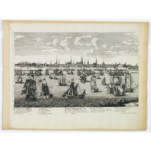
Amsterdam Ville du comté de Hollande. . .
A very decorative and very rare town view of Amsterdam, including a numbered key ( A- T) in the lower part. Engraved by Pierre-Alexandre Aveline. With the signature "Aveline avec privil. du Roy" in the lower right margin. Pierre Aveline (Paris, c.1656 - 23 May 1722), was an engraver, print-publisher and print-seller. He probably trained with Adam Pérelle and specialized in topographical representations like him. He engraved in suites many views of Paris and of provincial, European and African c...
$500
Maker : AVELINE, P.A.
Place : Paris
Date : 1692
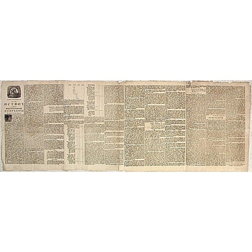
Nader prolongatie van het Octroy voor de Westindische Compagnie voor den tyd van nog dertig jaaren. . .
A proclamation by the Dutch States General, dated 1761, extending the charter of the Dutch West India Company for another thirty years. Like the 1730 proclamation, it has detailed information about the import of slaves from West Africa to Surinam, Essequibo and Berbice, where the WIC was granted a monopoly in the slave trade, while others could import slaves to Curaçao and other parts of America, as the proclamation notes.
$1.500
Maker : SCHELTUS, I.
Place : Amsterdam
Date : 1761
![Westelijk Halfrond. [Western hemisphere]](/uploads/cache/25524-500x500.jpg)
Westelijk Halfrond. [Western hemisphere]
Uncommon world map view of the western and eastern hemispheres of North and South America, Asia. Lithography by J.H. van Weijer, published in Atlas der geheele Aarde in 24 kaarten.
$50
Maker : SCHOLTENS, A.L.
Place : Groningen
Date : ca. 1860
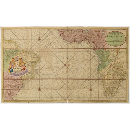
Nieuwe Wassende Graadige Pas-kaart van de Kust van Guinea en Brasilia.
Rare two-sheet sea chart of the coasts of Brazil, West Africa and South Africa, published by Johannes Van Keulen (the younger), circa 1720.The chart shows the western coast of Africa but the information provided in the map for Inland territories is wide. The South American coast of Brazil, the latter with a large, decorative, dedication cartouche inland, and Guyana. In the left-hand part a large dedicational cartouche to Abraham Anias, with the signature of Johannes van Keulen.Abraham Anias (169...
$2.250
Maker : VAN KEULEN, G.
Place : Amsterdam
Date : 1751
Postage & Shipping
-
Item Location
Terms and conditions - Item Location
- Amsterdam, , Netherlands
- Ships To
- United States, United Kingdom, Albania, Argentina, Armenia, Australia, Azerbaijan, Bahamas, Belgium, Bermuda, Cambodia, Canada, Chile, China, Croatia, Cyprus, Czech Republic, Denmark, Estonia, Finland, France, Germany, Gibraltar, Greece, Greenland, Guatemala, Hong Kong, Iceland, India, Indonesia, Israel, Italy, Japan, Latvia, Lithuania, Luxembourg, Malta, Mexico, Monaco, Netherlands, Norway, Singapore, Spain, Sweden, Switzerland, Turkey
- Pick-ups
- No pick-ups
This item is owned and offered by the seller Paulus_Swaen_Old_Maps - All items are available for immediate sale, offered subject to prior sale.
Invoices are created by the seller by using our shopping cart or be prepared by the seller the day following the order and are emailed to you.
Items offeres by different sellers are invoiced separately.
Shipping fees are extra. The buyer is responsible for all applicable taxes, including any VAT, customs clearance, import duties, or equivalent costs arriving at the customer's home border. Payment is due on receipt of the invoice. The item(s) are shipped as soon as possible after receipt of your payment.
Before buying please read the complete Terms Conditions of Sale.
- Payment Methods
- Visa, Mastercard, Bank Transfer, American Express, iDEAL, PayPal, Google Pay
- Returns Accepted
- No
Post Message
Feel free to ask the seller a question. Please note that the seller could be located in an area with a different time zone. Our seller will do their best to respond within 24 hours.Post your message below.
Sign in to ask the seller a question.
![[How the Indians cured the Spanish thirst for gold....by pouring it down their throats!]](/uploads/cache/40483-(1)-500x500.jpg)
![[Murder of Dominican monks in Cumana or Cubagua Island].](/uploads/cache/40177-500x500.jpg)