ID: 336
Open
Listing ID: #336 has been added to your wishlist.
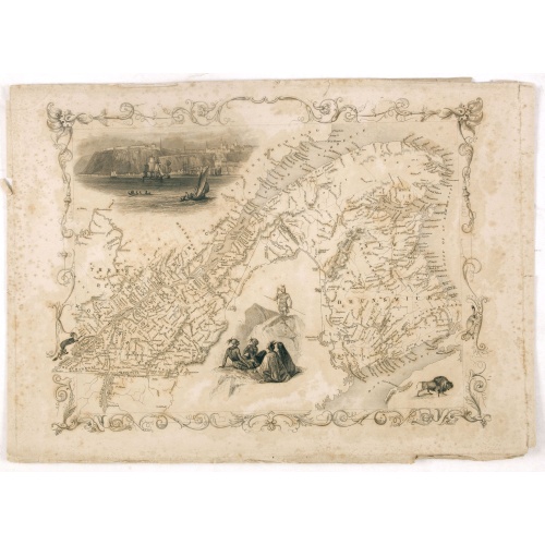
East Canada and New Brunswick.
BuyNow for $75
- Maker :
- TALLIS, J.
- Place :
- London
- Date :
- 1851
- Color :
- Uncolored.
- Height mm.:
- 260
- Width mm.:
- 350
- Condition :
- Paper age-toned and spotted. Some marginal tears.
- Bibliography :
- -
- Seller's ref. :
- 37283
This item is offered by Paulus_Swaen_Old_Maps
See other Items from this seller- Postage
-
Europe
$35 to France
- Select Country
- Zip/Post Code
- Quantity
$75
Description
This is John Tallis’ map of East Canada or what is now Quebec and New Brunswick. Includes Montreal, Quebec City, and the St. Lawrence River valley. Features five vignettes which include American Indian warriors and a spectacular view of Quebec City. The whole is surrounded by a decorative vine motif border. The vignettes for this map were drawn by H. Warren and engraved by J. B. Allen. The map itself is the work of John Rapkin.The Illustrations after a design by H. Warren and engraved by J Rapkin and J.Rogers. The Map was drawn and engraved by John Rapkin.
John Tallis a London publisher was one of the most popular cartographers of the 19th Century. He became famous for the very accurate and visually appealing maps that featured the extensive use of vignette views from around the World and ornamental perimeter engraving.
Principal engraver and mapmaker to John Tallis was John Rapkin, renowned for his extraordinary artistic and engraving skills. Between them they produced many books of travel and exploration.
Carte Generale des Dixet Sept Provinces des Pays Bas.
Rare map of the Low Countries, including Belgium, the Netherlands and Luxembourg after Tassin and offered for sale by the publisher N. Berey.
$650
Maker : BEREY, N. / TASSIN, C.
Place : Paris
Date : 1634
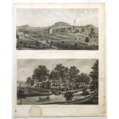
Résidence of WM H.Drew Southeast Putnam Co.N.Y / Lake Farm Résidence of John V.Storm East Fiskill Dutches Co.N.Y.
Two heliographic prints on one sheet : " Résidence of WM H.Drew Southeast Putnam Co.N.Y / Lake Farm Résidence of John V.Storm East Fiskill Dutches Co.N.Y." after design by R.K.Sneden.From Beer's famous county atlas "Atlas of New York and vicinity", "a documentary record of nineteenth century life and delightful specimens of American folk art". F. W. Beers, along with other members of his family, were among the leading county atlas publishers in period immediately following the Civil War. Their...
$90
Maker : DE BEERS, F.W.
Place : New York,1867
Date : 1867
[Religious ritual on Hispaniola].
Scarce print with a German text sheet.On certain feast-days the Indian cacique, while beating a drum, led a procession of his people to the worship of their idol, which was a strange hybrid-like creature with several heads. The men were painted black, red and yellow and came first, dressed in parrot feathers and necklaces of seashells. The women, decorated with jewellery, followed with their naked daughters. When all were assembled, the cacique inserted a stake into his throat, which made him vo...
$80
Maker : GOTTFRIED, J.L. / DE BRY.
Place : Frankfurt, M.Merian
Date : 1633
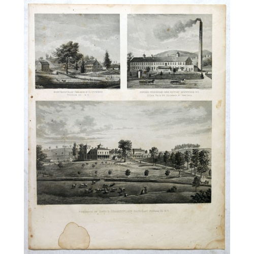
Mount Vernon Valley Residence of S.J. Powers / Borden condensed milk factory brewsters N.Y / Residence of Dan D. Chamberlain South East Putman Co. N.Y.
Three heliographic prints on one sheet : "Mount Vernon Valley Residence of S.J. Powers (135 x 155mm.) / Borden condensed milk factory brewsters N.Y (135 x 155mm.) / Residence of Dan D. Chamberlain South East Putman Co. N.Y. (190 x 155mm.) " after design by R.K.Sneden.From Beer's famous county atlas "Atlas of New York and vicinity", "a documentary record of nineteenth century life and delightful specimens of American folk art". F. W. Beers, along with other members of his family, were among the l...
$90
Maker : DE BEERS, F.W.
Place : New York
Date : 1867
Postage & Shipping
-
Item Location
Terms and conditions - Item Location
- 75013, Ile-de-France, France
- Ships To
- United States, United Kingdom, Albania, Argentina, Armenia, Australia, Azerbaijan, Bahamas, Belgium, Bermuda, Cambodia, Canada, Chile, China, Croatia, Cyprus, Czech Republic, Denmark, Estonia, Finland, France, Germany, Gibraltar, Greece, Greenland, Guatemala, Hong Kong, Iceland, India, Indonesia, Israel, Italy, Japan, Latvia, Lithuania, Luxembourg, Malta, Mexico, Monaco, Netherlands, Norway, Singapore, Spain, Sweden, Switzerland, Turkey
- Pick-ups
- No pick-ups
This item is owned and offered by the seller Paulus_Swaen_Old_Maps - All items are available for immediate sale, offered subject to prior sale.
Invoices are created by the seller by using our shopping cart or be prepared by the seller the day following the order and are emailed to you.
Items offeres by different sellers are invoiced separately.
Shipping fees are extra. The buyer is responsible for all applicable taxes, including any VAT, customs clearance, import duties, or equivalent costs arriving at the customer's home border. Payment is due on receipt of the invoice. The item(s) are shipped as soon as possible after receipt of your payment.
Before buying please read the complete Terms Conditions of Sale.
- Payment Methods
- Visa, Mastercard, Bank Transfer, American Express, iDEAL, PayPal, Google Pay
- Returns Accepted
- No
Post Message
Feel free to ask the seller a question. Please note that the seller could be located in an area with a different time zone. Our seller will do their best to respond within 24 hours.Post your message below.
Sign in to ask the seller a question.


-500x500.jpg)

![[Religious ritual on Hispaniola].](/uploads/cache/39921-500x500.jpg)

