
ID: 360
Open
Listing ID: #360 has been added to your wishlist.
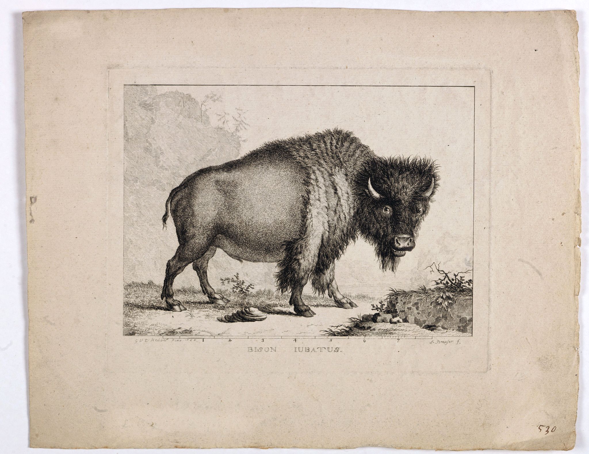
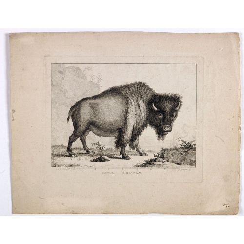
Bison Iubatus.
BuyNow for €750
- Maker :
- BRASSIER, L
- Place :
- Rotterdam
- Date :
- 1766-1793
- Color :
- Uncoloured
- Height mm.:
- 170
- Width mm.:
- 218
- Condition :
- Good impression. Wide margins. Paper slightly age toned.
- Bibliography :
- -
- Seller's ref. :
- 40700
This item is offered by Librairie_Loeb-Larocque
See other Items from this seller- Postage
-
France
€15 to France
- Select Country
- Zip/Post Code
- Quantity
€750
Description
Etching of a bison by Leendert Brasser (1727 - 1793) after a painting of the Dutch artist Gerrit van den Heuvel.An early portrait of a bison, etched by Leendert Brasser (1727-93) after Gerrit van den Heuvel.
Gerrit van den Heuvel portraited this bison in 1766 in the menagerie of Arnout Vosmaer (1720 - 1799). Vosmaer was a Dutch naturalist and collection curator. In 1756 Vosmaer became the director of a natural history collection started by Princess Anna, the wife of William IV, Prince of Orange and continued by their son William V. Vosmaer held the post until the Batavian Revolution in 1795.
Vosmaer produced a series of 34 booklets describing animals that were published between 1766 and 1805 in both Dutch and French. Most were on species kept in Prince William V's menagerie. Vosmaer wrote in 1772 "Beschryving van den Amerikaanschen gebulten stier genaamd bison".
The illustration was one of the earliest presentations of a bison in the Netherlands.
The American bison or simply bison, also commonly known as the American buffalo, is an American species of bison that once roamed North America in vast herds. It nearly became extinct by a combination of commercial hunting and slaughter in the 19th century and introduction of bovine diseases from domestic cattle. Through multiple reintroductions, the species is now also freely roaming wild in some regions in Yakutia as well as Mexico.
![[Spilbergen's fleet visits the island of Santa Maria] / [The Dutch visit Isla Mocha].](/uploads/cache/41090-500x500.jpg)
[Spilbergen's fleet visits the island of Santa Maria] / [The Dutch visit Isla Mocha].
Two engravings. [514] On 29th May, 1615, Spilbergen’s fleet anchored further north, off an island called Santa María that was separated by a narrow stretch of water (A), from Punta Lavapié on the mainland. Four of the ships (I) anchored in the bay, while the fifth (H) anchored closer. The Dutch went ashore in small boats (F), where they saw Spanish soldiers on horseback (B), so they arranged themselves for battle (C). There were several confrontations (E), during which many Dutchmen died but...
€80
Maker : GOTTFRIED, J.L. / DE BRY.
Place : Frankfurt, M.Merian
Date : 1633
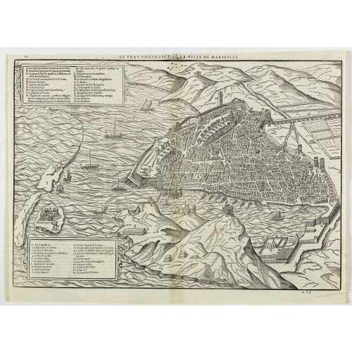
Le vray portraict de la Ville de Marseille.
Fine wood cut bird's-eye view of Marseille. Decorated with several ship in the harbour and on the sea. To the left two keys describing the main buildings and places. Published in "La Cosmographie Universelle de tout le monde", printed in 1575 in Paris by Nicolas Chesneau and Michel Sonnius with the French text by Francois de Belleforest.The book is a French version of Sebastian Münster's "Cosmographia Universalis".
€800
Maker : BELLEFOREST, F. de.
Place : Paris
Date : 1575

François.
A charming engraving of a French couple in 17th-century dress.Title in a curtain draped at top. French text on verso.From the original 1683 text edition of "Description d'Univers. . ." by Allain Manesson Mallet (1630-1706), a well travelled military engineer and geographer who worked in 17th century France under King Louis XIV.Published by Denys Thierry.
€50
Maker : MANESSON MALLET, A.
Place : Paris
Date : 1683
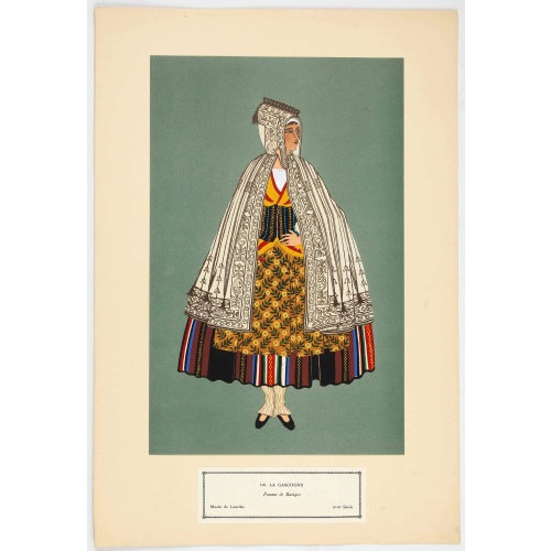
Femme de Barèges (106, La Gascogne).
Plate published in "Les costumes régionaux de France" with illustrations by Gratiane de Gardilanne (painter and designer) and Elisabeth Whitney Moffat.Costume plate printed in collotype, pochoir and retouched by hand. Dimension of 24.5 x 38cm. The originals were donated by an American patron to the Metropolitan Museum of Art in New York and constitute a set of 200 plates. Good condition.
€75
Maker : GARDILANNE (G.de) et MOFFAT (E.W.)
Place : Paris, Editions du Pégase, 1929
Date : 1929
Postage & Shipping
-
Item Location
Terms and conditions - Item Location
- 75013, Ile-de-France, France
- Ships To
- United States, United Kingdom, Albania, Argentina, Armenia, Australia, Austria, Bahamas, Belgium, Bermuda, Bosnia and Herzegowina, Brazil, Bulgaria, Canada, Chile, China, Costa Rica, Denmark, Dominica, Egypt, El Salvador, Finland, France, Germany, Greece, Guatemala, Hong Kong, Hungary, Iceland, India, Italy, Japan, Korea (South), Kuwait, Liechtenstein, Lithuania, Luxembourg, Madagascar, Mexico, Monaco, Morocco, Netherlands, Netherlands Antilles, New Zealand, Norway, Paraguay, Peru, Philippines, Poland, Portugal, Qatar, Reunion, Romania, San Marino, Saudi Arabia, Seychelles, Singapore, Slovenia, South Africa, Spain, Sri Lanka, Suriname, Sweden, Switzerland, Taiwan, Thailand, Tunisia, Turkey, United Arab Emirates, Uruguay, Vietnam
- Pick-ups
- No pick-ups
This item is owned and offered by the seller Librairie_Loeb-Larocque - All items are available for immediate sale, offered subject to prior sale.
Invoices are created by the seller by using our shopping cart or be prepared by the seller the day following the order and are emailed to you.
Items offeres by different sellers are invoiced separately.
Shipping fees are extra. The buyer is responsible for all applicable taxes, including any VAT, customs clearance, import duties, or equivalent costs arriving at the customer's home border. Payment is due on receipt of the invoice. The item(s) are shipped as soon as possible after receipt of your payment.
Before buying please read the complete Terms Conditions of Sale.
- Payment Methods
- Visa, Mastercard, Bank Transfer, American Express, iDEAL, PayPal, Google Pay
- Returns Accepted
- No
Post Message
Feel free to ask the seller a question. Please note that the seller could be located in an area with a different time zone. Our seller will do their best to respond within 24 hours.Post your message below.
Sign in to ask the seller a question.
![[Dutch attack the fortress of Praia.]](/uploads/cache/39901-500x500.jpg)