ID: 364
Open
Listing ID: #364 has been added to your wishlist.
Listing ID: #216 has been added to your wishlist.
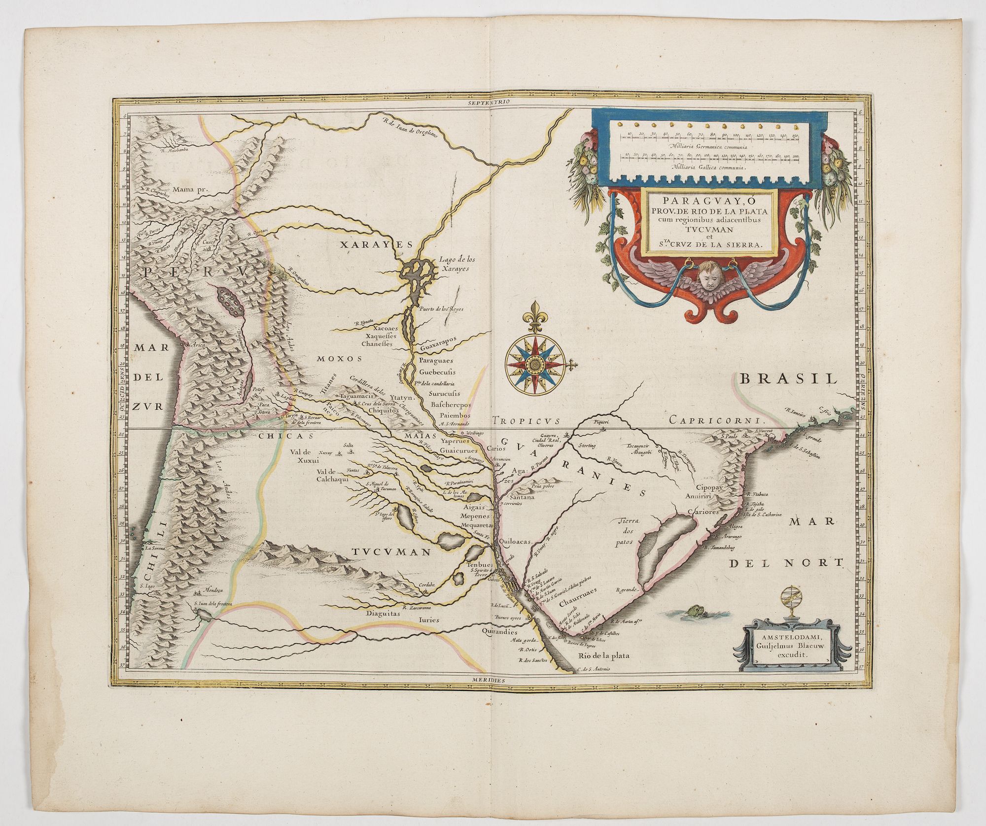
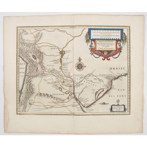
Paraguayo prov. de Rio de La Plata cum regionibus..
BuyNow for €600
- Maker :
- BLAEU, W.
- Place :
- Amsterdam
- Date :
- 1644
- Color :
- In original colors.
- Height mm.:
- 373
- Width mm.:
- 481
- Condition :
- Good margins. In very good condition. French text on verso.
- Bibliography :
- -
- Seller's ref. :
- 45173
This item is offered by Librairie_Loeb-Larocque
See other Items from this seller- Postage
-
France
€15 to France
- Select Country
- Zip/Post Code
- Quantity
€600
Description
A beautiful map of Paraguay, and parts of Peru, Chile, Argentina, Brazil and Bolivia. Much of the area was still "Terra Incognita" so there are few towns and cities shown. The Andes are clearly shown to the west as well as the river systems.
The Renaissance cartouche adds a special decorative accent to the map. The small cartouche in the lower right gives the name of the publisher.
From early on Willem Jansz. Blaeu aimed of publishing an atlas to compete with the Hondius-Jansson Atlas. By 1630, he had published at least 17 folio size maps.
Blaeu was able to realize his plan soon after he had acquired the copper plates of the atlas maps by Jodocus Hondius. The "Appendix followed in 1630.
In 1635 he finally realized a "international edition" of a world atlas, the "Theatrum Orbis Terrarum".
-500x500.jpg)
Dépt. De La Haute Loire. N°42.
Map of the Upper Loire region in France.Lovely map from one of the last decorative atlases of the nineteenth century.The rather simple map is framed by medallion portraits and coats of arms, and is set against a background of scenes of the countryside, products and activities indigenous to the region filling the foreground.Victor Levasseur's "Atlas National Illustre" and "Atlas Universel Illustre" are among the last great decorative atlases published. This map comes from the Atlas National Illus...
€50
Maker : LEVASSEUR, V.
Place : Paris
Date : A. Combette, 1852
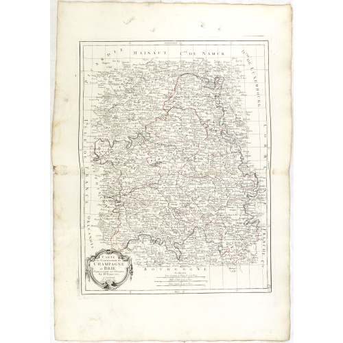
Gouvernements de Champagne et Brie.
Detailed map encompassing Champagne and Brie.Venetian edition of the map by Bonne, to whom Santini gives credit in the cartouche.From "Atlas Universel" published by Santini in 1776-84. The atlas is effectively an Italian copy of the Robert de Vaugondy 'Atlas Universel'.In 1784 Santini sold the plates to M. Remondini, whose name appears on this particular example.
€75
Maker : SANTINI, P. / REMONDINI, M.
Place : Venice
Date : 1776 - 1784
Nieuw Nederlandtsch Caertboeck. Waer in volkomentlijcker als oyt te voren vertoont werden de XVII. Nederlanden.
Rare first edition of this atlas of the provinces of the Netherlands, Belgium and Luxemburg. Engraved title page, with : "Gedruckt t' Amsterdam by Abraham Goos Plaetsnyder wonende op den Dam in 't vergulde Caertboeck.Our atlas is conform to the copy described in Koeman/Krogt : "One copy is known of the B-edition without text (Brussel KB IV). All maps in this copy are in the second variant".A. Goos published on his own a single atlas, the " Nieuw Nederlandtsch Caertboeck" with 23 maps. He receive...
$3.000
Maker : GOOS, A.
Place : Amsterdam
Date : 1616
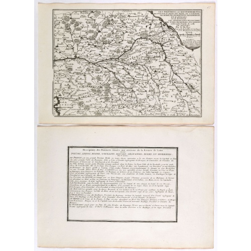
Les Provinces, ou Gouvernement de Poictou, d'Anjou, du Maine, De Touraine . . .
Map centered on Loire region, with Blois, Saumur, Sancerre and Orleans, from Nicolas de Fer's "L'Atlas curieux ou le Monde réprésente dans des cartes. "The "Atlas Curieux" is a geographic encyclopedia of images and a celebration of the French Empire under the Sun King, with maps of French possessions in the western hemisphere, maps of France, with detailed views of the grand waterworks at Marly, views of the great palaces and chateaux, views and plans of the Paris Observatory, and samples of m...
€80
Maker : DE FER, N.
Place : Paris
Date : 1705
Postage & Shipping
-
Item Location
Terms and conditions - Item Location
- 75013, Ile-de-France, France
- Ships To
- United States, United Kingdom, Albania, Argentina, Armenia, Australia, Austria, Bahamas, Belgium, Bermuda, Bosnia and Herzegowina, Brazil, Bulgaria, Canada, Chile, China, Costa Rica, Denmark, Dominica, Egypt, El Salvador, Finland, France, Germany, Greece, Guatemala, Hong Kong, Hungary, Iceland, India, Italy, Japan, Korea (South), Kuwait, Liechtenstein, Lithuania, Luxembourg, Madagascar, Mexico, Monaco, Morocco, Netherlands, Netherlands Antilles, New Zealand, Norway, Paraguay, Peru, Philippines, Poland, Portugal, Qatar, Reunion, Romania, San Marino, Saudi Arabia, Seychelles, Singapore, Slovenia, South Africa, Spain, Sri Lanka, Suriname, Sweden, Switzerland, Taiwan, Thailand, Tunisia, Turkey, United Arab Emirates, Uruguay, Vietnam
- Pick-ups
- No pick-ups
This item is owned and offered by the seller Librairie_Loeb-Larocque - All items are available for immediate sale, offered subject to prior sale.
Invoices are created by the seller by using our shopping cart or be prepared by the seller the day following the order and are emailed to you.
Items offeres by different sellers are invoiced separately.
Shipping fees are extra. The buyer is responsible for all applicable taxes, including any VAT, customs clearance, import duties, or equivalent costs arriving at the customer's home border. Payment is due on receipt of the invoice. The item(s) are shipped as soon as possible after receipt of your payment.
Before buying please read the complete Terms Conditions of Sale.
- Payment Methods
- Visa, Mastercard, Bank Transfer, American Express, iDEAL, PayPal, Google Pay
- Returns Accepted
- No
Post Message
Feel free to ask the seller a question. Please note that the seller could be located in an area with a different time zone. Our seller will do their best to respond within 24 hours.Post your message below.
Sign in to ask the seller a question.