
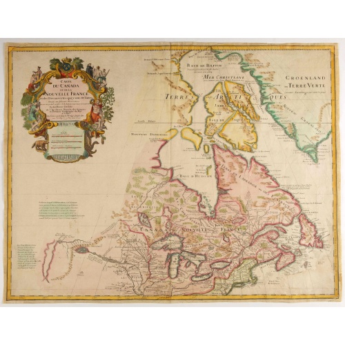
Carte du Canada ou de la Nouvelle France.
Fourth state of the map of Canada published by Delisle with the imprint "sur le Quai de l’Horloge a l’Aigle d’Or avec Privilege pour 20 ans, 1703". Beneath the title, Renard’s imprint is erased.Including the fictitious discoveries of Baron de Lahoutan: the legendary River Longue etc. The north west corner of Hudson Bay is left open, leaving the possibility of a north west passage open. De l'Isle's map was the first to show Detroit (founded by Cadillac) and the first to mention a settleme...
€500
Maker : DE L'ISLE, G.
Place : Paris
Date : 1703
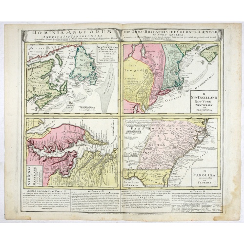
Dominia Anglorum in America Septentrionali.
Four maps on one sheet (New Found land/ New England/ Virginia and Carolina/Florida) based on J.B.Homann's map, showing British possessions in North America. The upper left shows territory in Newfoundland and around the Bay of St. Lawrence, with portions of the ‘lost’ colony of New Scotland. The Grand Banks are prominently noted as well. The map immediately to the right shows claims in New York and New England, with large areas in Pennsylvania noted as belonging to the Iroquois. The lower lef...
€750
Maker : HOMANN HEIRS.
Place : Nuremberg 1740
Date : 1740
![[Upper sheet map only] The Provinces New York, and New Jersey with part of Pensilvania and the Province of Quebec.](/assets/images/image-loading.svg)
[Upper sheet map only] The Provinces New York, and New Jersey with part of Pensilvania and the Province of Quebec.
Rare separately issued map, unfortunately only the upper part of the map. It is a variant of this important colonial map. The upper sheet showing the upper course of the St. Lawrence River. With 3 large insets: 1) A Chart of the Mouth of Hudson's River from Sandy Hook to New York. This is in effect a chart of New York Harbor, with depth soundings, shoals, and other marine information laid down. 2) A Plan of Amboy. The city of Perth Amboy, the old capital of New Jersey, and the most important por...
€750
Maker : HOLLAND, S./ BROENNER, H.L.
Place : Frankfurt
Date : 1777
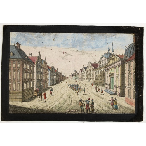
Prospect des Haupt Plazes der Untern Stadt zu Quebec.
A so-called optical print showing a decorative imaginary town view of Québec, with a street view with soldiers marching and pedestrians, an idealized view depicting Québec as a typical European city.By Franz Xavier Habermann (1721-1796).This print is a fine example of this illusionary printmaking, but also as a testament to the strong interest by Europeans in America at the time and also as a fine example of the perspective view.In the eighteenth and nineteenth centuries, there were many popul...
$500
Maker : ACADEMIE
Place : Augsburg, ca.1780
Date : 1780
[Lot of 2 maps] Important plan of Port Bucarelli 1384 / Chart of the entrance of "Bassin de L'Quest", La Perouse. 1709
Chart of the entrance of "Bassin de L'Quest", La Perouse. 1709 / With antique print of Alaska] Pirogue du port des Francais. / Pirogue, trouvee au port des Francais. 5958 / [Antique map of Alaska] Plan der Haven van Namganoodha in het eiland van Oonolaska. 2665 / Antique detail chart of the Nootka Channel] Schets van het Kanaal van Nootka. 3860. Plus 6 prints of natives of Alaska and their utensils. A plan of Port Bucarelli, Jean François Galoup, Comte de la Pérouse (1741-88), outstanding Fren...
€350
Maker : La Pérouse, J.B.G. Comte de.
Place : Paris
Date : 1797
[Lot of 5 maps] Kaart van de noord-west kust van Amerika en de noord-oost kust van Asia.
- Kaart van de noord-west kust van Amerika en de noord-oost kust van Asia. Opgenoomen in de Jaaren 1778 en 1779.Captain James Cook (1728-79), explorer, circumnavigator and hydrographer. Three voyages, 1768-71, 1772-75 and 1776-79. From 1778 on printed editions of ' Captain Cook's Travels' appeared in English, Italian, French and Dutch east coast. From a Dutch edition of Cook's voyages'.- Carte d'une Partie DE L'AMERIQUE SEPTRIONALE qui comprendles POSSESSIONA ANGLAISES. This map depicts colonia...
€300
Maker : COOK, J.
Place : Leiden
Date : 1795-1803
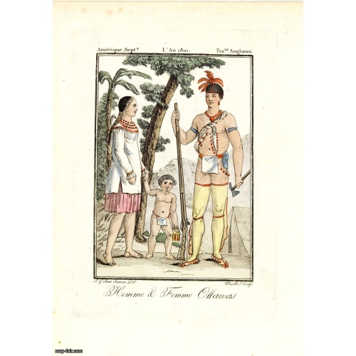
Homme & Femme Ottawas.
Hand-colored mezzotint of Native Americans engraved by Félix Mixelle and Lachaussée Jeune after Jacques Grasset de Saint-Sauveur.As an etcher, drawer and writer, Grasset de Saint-Sauveur was a prolific polygraph in keeping with the encyclopedic spirit of the eighteenth century: he wrote exotic novels as well as documentary works on various subjects. Called by one of his biographers a drawer without genius but a good example of the taste of his time, Grasset de Saint-Sauveur was literally bewit...
$75
Maker : GRASSET DE SAINT SAUVEUR,J.
Place : Paris,
Date : 1806
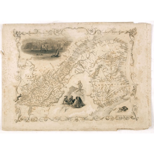
East Canada and New Brunswick.
This is John Tallis’ map of East Canada or what is now Quebec and New Brunswick. Includes Montreal, Quebec City, and the St. Lawrence River valley. Features five vignettes which include American Indian warriors and a spectacular view of Quebec City. The whole is surrounded by a decorative vine motif border. The vignettes for this map were drawn by H. Warren and engraved by J. B. Allen. The map itself is the work of John Rapkin. The Illustrations after a design by H. Warren and engraved by J Ra...
$75
Maker : TALLIS, J.
Place : London
Date : 1851