
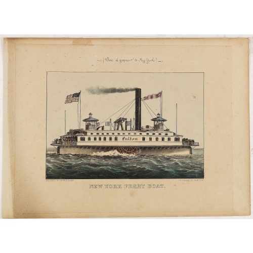
New York Ferry Boat. (Bac à vapeur de New York).
A very decorative print showing the New York Ferry Boat "Fulton," published by Currier & Ives. The Ferry boat "Fulton" sails to the right. A single smokestack trails smoke, and two flags blow to the left. Passengers, horses, and a carriage are visible on deck, and a captain is in the wheelhouse at right.Published by Currier & Ives 125 Nassau Street, New York."Currier & Ives was a New York publishing firm that produced and sold thousands of impressions of more than 7,000 different lithographic pr...
$550
Maker : CURRIER & IVES.
Place : New York
Date : ca. 1875
-500x500.jpg)
Nouvelle carte de l'Amérique Septentrionale et des iles qui en dépendent dressée par H. Brué. . .
Very large, highly detailed, and uncommon issue of the map of North and Central America (ca. 1:13,888,000) prepared by H. Brué and improved by A.Vuillemin. Showing main interregional routes, rivers, and canals.The map was published in the year of The Texas Constitution of 1876. Texas still operates under the 1876 constitution today.Between the years of 1824 and 1876, Texas was at times a part of the United States of Mexico, an independent republic, a state within the Confederate States of Ameri...
$500
Maker : LOGEROT, A.
Place : Paris
Date : 1875
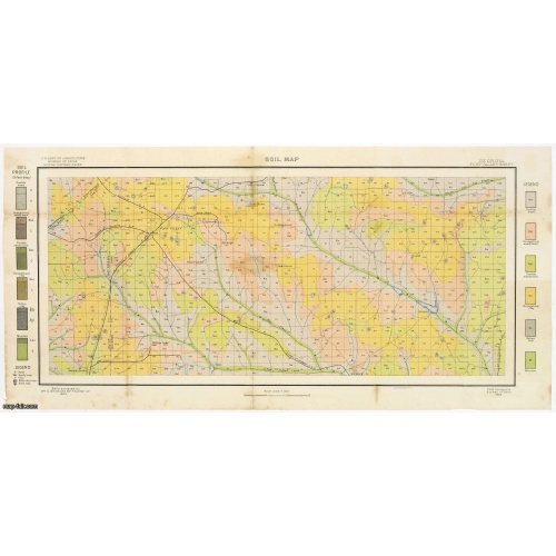
Soil map - Georgia, Fort Valley sheet.
Early color lithographed soil map by Julius Bien & Co. in New York for Department of Agriculture. Legends at side give detail on soil type, etc. They also include interesting details of the cities, roads, railroads, rivers, canals, etc. Scale of 1" = 1 mile. The map is giving great detail of the area in the year 1903. Soils are surveyed by Wm. G. Smith and Wm. T. Carter Jr. in the same year. To the left and right color keys to the different types of soil.Upper left: U.S.Department of Agricult...
$50
Maker : U.S. DEPT. OF ARGICULTURE
Place : New York, 1903
Date : 1903
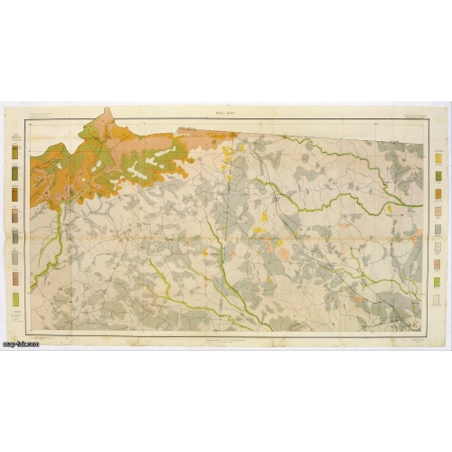
Soil map - South Carolina Campobello Sheet.
Early color lithographed soil map by Julius Bien & Co. in New York for the Department of Agriculture. Legends at the side provide detail on soil type, etc. They also include interesting details of the cities, roads, railroads, rivers, and canals. A scale of 1" = 1 mile. The map gives great detail of the northern part of South Carolina, including Spatanburg and the area northwest of it, with Tiger River, South Pacolet River, and North Saluda River in the lower right-hand corner, in 1903. A.G. Man...
$50
Maker : U.S. DEPT. OF ARGICULTURE
Place : New York, 1903
Date : 1903
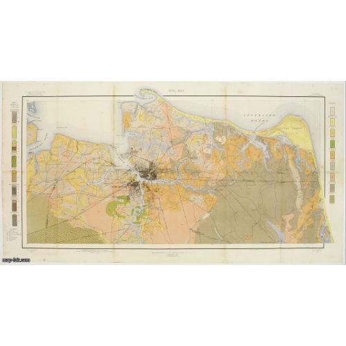
Soil map - Virginia Norfolk Sheet.
Soil map printed by Julius Bien & Co. in New York for the Department of Agriculture. The map gives great detail of the area centered on Norfolk, Potsmouth, Chesapeake, Virginia Beach in the year 1903. Soils are surveyed by J.E.Lapham in the same year. To the left and right, color keys to the different soil types.Upper left: U.S.Department of Agriculture, Bureau of soils, Milton Whitney, Chief.Julies Bien (later Bien & Co) was born and educated in Germany, and moved to America in 1849. He started...
$50
Maker : U.S. DEPT. OF ARGICULTURE
Place : New York 1903
Date : 1903
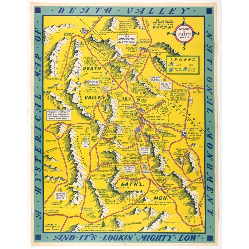
A Hysterical Map Of Death Valley National Monument -- And It's Looking Mighty Low
First edition Humorous map of Death Valley. "Drawn In Broken English by Jolly Lindgren," this comic pictorial map is full of puns and comic vignettes related to Death Valley. The Lindgren Brothers issued a number of other silly whimsical maps of national parks and other parts of the West.
$500
Maker : LINDGREN, J.
Place : Spokane, Wash., Lindgren Brothers,
Date : 1948