
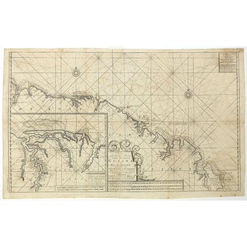
Nieuwe gelyk Graadige Paskaart van de Kust van Guiana in West-Indien.
Detailed chart of Guiana in South America. Two scales are given in both maps: Dutch, French and English nautical miles.The inset chart provide detailed view of the Camopi and Maroni or Marowijne Rivers that forms the border between French Guiana and Suriname. The charts are prepared by Johannes Loots and H.Mooy.
$650
Maker : VAN KEULEN, G.
Place : Amsterdam
Date : 1684 - 1704
-500x500.jpg)
Carte de la Guyane Françoise et l'Isle de Cayenne..
A well engraved and highly detailed chart of French Guiana and the island of Cayenne. Made in 1763 by Jacques Bellin (1703-72), a prolific cartographer assigned the Ministry of the French Navy. It shows soundings, anchorage's, channels, shoals, navigational sightings. Engraved by Croisey, engraver for the Depot Générale de la marine is noted as such on the map.
€500
Maker : BELLIN, J. N.
Place : Paris
Date : 1763

Carta esférica del Rio de la Plata : desde su embocadura hasta Buenos Aires.
Large nautical chart illustrating the estuary formed by the combination of the Uruguay River and the Paraná River. It forms part of the border between Argentina and Uruguay, with the major ports and capital cities of Buenos Aires in the southwest and Montevideo in the northeast.
$750
Maker : DIRECTION HIDROGRAFICA
Place : Madrid
Date : 1812-1838

A general chart of the South Atlantic Ocean Drawn by J.W.Norie hydrographer. Revised & Corrected 1854.
A 2-sheet chart of the South Atlantic Ocean, showing the coast of South America from the mouth of the Amazon to Quito in Peru. The right hand part showing Africa's coast at Angola. Scale: circa 1:8,000,000. Chart of the South Atlantic, in two sheets. Two insets, Port of Ascension and Anchorage off N.W. side of St. Helena.The chart is published for the first time in 1833, according to a date lower part map. This is A Revised & corrected edition by J.W. Norie in 1854
$600
Maker : NORIE, J.W.
Place : London
Date : 1854