
ID: 107
Open
Freedom of the Air.
BuyNow for $230
- Maker :
- ALCOA ALUMINUM COMPANY.
- Place :
- United-States
- Date :
- 1943
- Color :
- Printed colors
- Height mm.:
- 850
- Width mm.:
- 605
- Condition :
- Offset. Creasing along fold lines, some of which have small tears along the folds that have been repaired on the verso. Very good overall, with bright colors lithographed on a clean sheet.
- Bibliography :
- -
- Seller's ref. :
- 47149
This item is offered by Paulus_Swaen_Old_Maps
See other Items from this seller- Postage
-
Europe
$34 to Netherlands
- Select Country
- Zip/Post Code
- Quantity
$230
Description
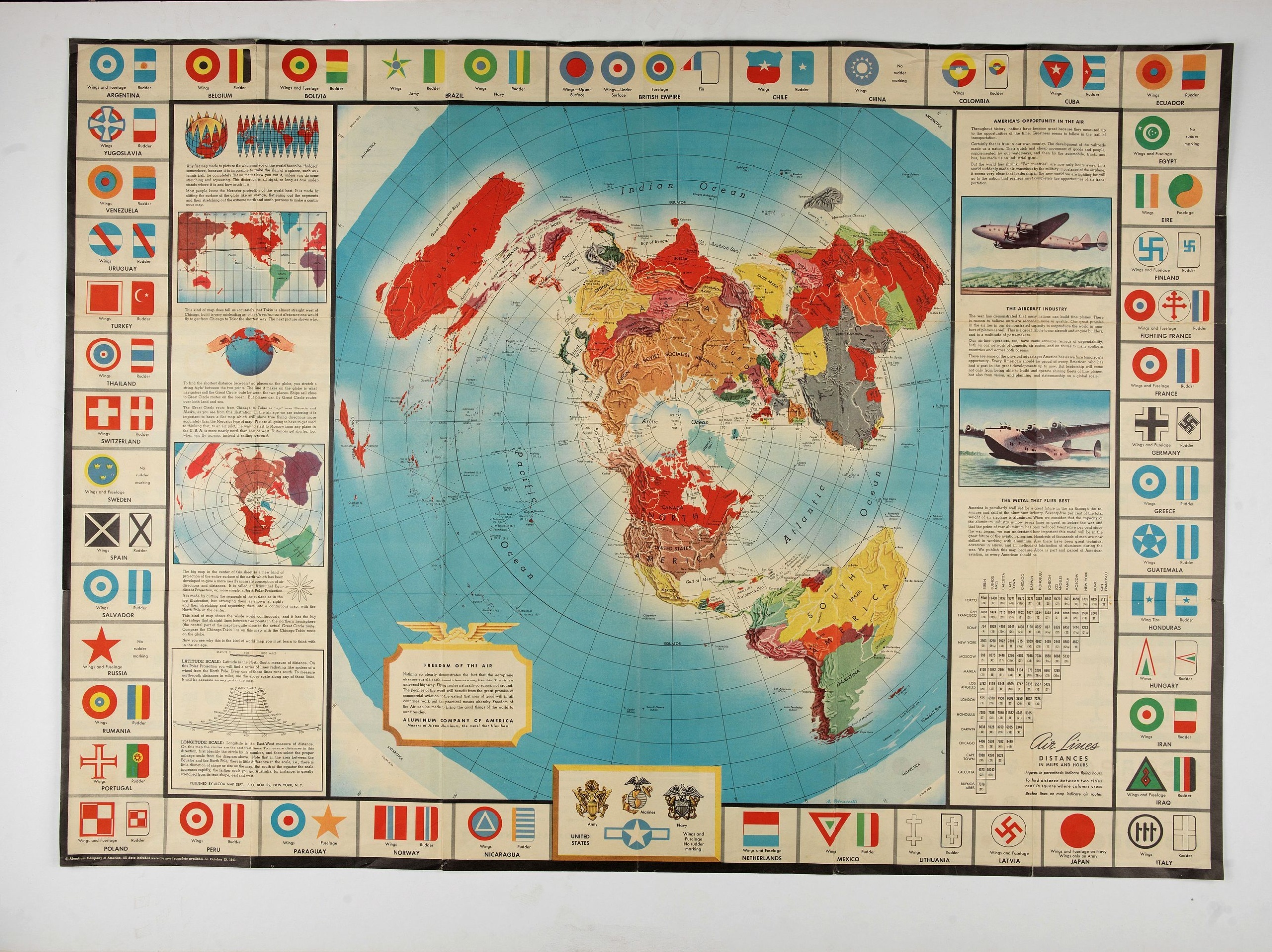
A world map packed with information about aviation and the aluminum industry.The use of aircraft in warfare, especially in the roles of close ground support and strategic bombing, was completely revolutionized during WWII. Apart from tactics, the technology also evolved to facilitate heavier bombers, faster fighters, more capable transports and greater range all-around.
One critical component of this development was using light, flexible and sturdy aluminum frames and skins for the planes, rather than the wood and canvas popularized during WWI.
Alcoa, a major American aluminum manufacturer, was well poised to capitalize on these wartime developments and issued this map to educate the American public about the company’s role in the conflict.
The main image is a world map on a polar projection (or Azimuthal Equidistant, if you want to get technical) which highlights the shortened distances between locations on the globe via air.
The explanatory text regarding the map’s projection and the benefits of aluminum can be found on either side of the map, while the border is comprised of the wing, rudder and tail markings of aircraft from major countries around the world. Interestingly, the belligerent status (Allied, Axis, Neutral) seems to play no part in the selection of the countries depicted. Neutral Spain, “Fighting France,” the Chinese Nationalists, occupied Poland and “Eire” (Ireland) are all shown.
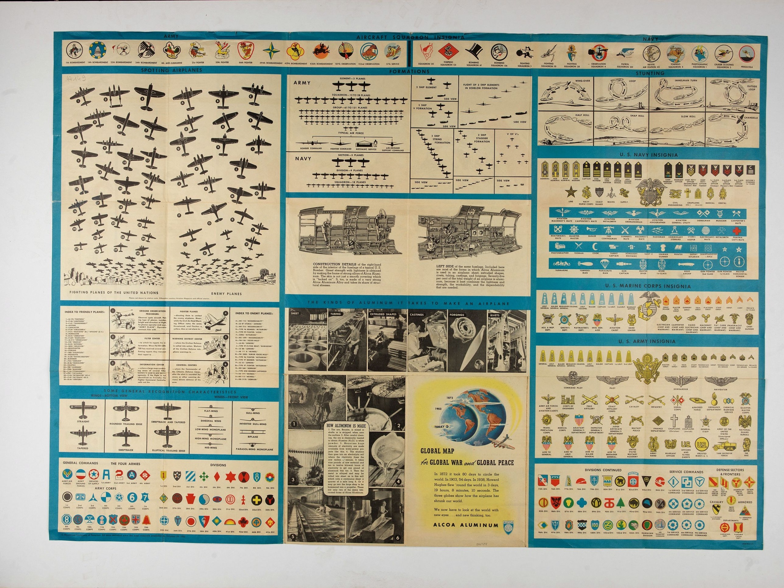
Aviation information continues on the verso of the sheet, which contains numerous charts and diagrams of military insignia, unit logos, profiles of Allied and Axis aircraft, the organizational structure of air corps, and even illustrations of specific dogfighting techniques.

Universe Europae Maritime Eiusque Navigationis Descriptio. Generale Pascaerte van Europa . . .
This general chart of north-western Europe and the surrounding coastal waters is from the rare pilot-guide De Spiegel der Zeevaerdt , printed by Christopher Plantin in Leyden.FIRST PLATE AND FIRST STATE, which appeared in the first 3 editions, before Latin names of some seas and inscriptions in the scale bars were added. (editions 4-12). EXTREMELY RARE.The map's title is given in both Latin and Dutch, with the latter attributing it to Waghenaer and nothing a privilege of ten years. The date 1583...
$25.000
Maker : WAGHENAER, L.J.
Place : Leyden
Date : 1584

A ship's hour glass.
Maritime hourglass with blown glass bulbs, orange sand, junction ring covered with cord, the circular ebony frame with six turned baluster columns.The invention of the hourglass is attributed to an 8th-century monk in Chartres, France, with the marine sandglass appearing as early as the 14th century. In earlier examples, the bulbs were connected with a material such as putty or hardened wax, bound in leather, linen or string. From about 1720, the two bulbs were welded together over a brass bead ...
$1.750
Maker : ANONYMOUS
Place : The Netherlands or Germany
Date : ca. 1750

Marine parallel rulers in brass.
Very fine marine parallel rulers in brass. The parallel ruler is the oldest and most traditional way to measure and trace routes and bearings. The principle is simple: the ruler is placed on the road to be measured and then, like a pantograph, the other part of the ruler is placed on one of the declination roses on the map to determine the angle. They are, essentially, two straight-edges hinged so that they maintain the same angle. By alternating the moving edge, and securely holding down the no...
$1.500
Maker : ANONYMOUS
Place : Paris
Date : ca. 1880

Zee caerte vande Sondt tvermaerste van Danemarcke . . .
A detailed chart of the coast of Denmark and its islands, Copenhagen in the center of the chart. West to the top. It is decorated by a title, scale and descriptive cartouche, a compass rose, several vessels and sea monsters, and depictions of mountains, fields, trees, small villages and animals.The chart shows soundings, sandbanks, landmarks and coastal profiles.Chart from an early Dutch text edition of this landmark contribution to the science of navigation. Waghenaer's own experiences as a pil...
$3.000
Maker : WAGHENAER, L. J.
Place : Leiden, Plantijn
Date : 1585
Postage & Shipping
-
Item Location
Terms and conditions - Item Location
- Paris, Ile-de-France, France
- Ships To
- United States, United Kingdom, Albania, Argentina, Armenia, Australia, Azerbaijan, Bahamas, Belgium, Bermuda, Cambodia, Canada, Chile, China, Croatia, Cyprus, Czech Republic, Denmark, Estonia, Finland, France, Germany, Gibraltar, Greece, Greenland, Guatemala, Hong Kong, Iceland, India, Indonesia, Israel, Italy, Japan, Latvia, Lithuania, Luxembourg, Malta, Mexico, Monaco, Netherlands, Norway, Singapore, Spain, Sweden, Switzerland, Turkey
- Pick-ups
- No pick-ups
This item is owned and offered by the seller Paulus_Swaen_Old_Maps - All items are available for immediate sale, offered subject to prior sale.
Invoices are created by the seller by using our shopping cart or be prepared by the seller the day following the order and are emailed to you.
Items offeres by different sellers are invoiced separately.
Shipping fees are extra. The buyer is responsible for all applicable taxes, including any VAT, customs clearance, import duties, or equivalent costs arriving at the customer's home border. Payment is due on receipt of the invoice. The item(s) are shipped as soon as possible after receipt of your payment.
Before buying please read the complete Terms Conditions of Sale.
- Payment Methods
- Visa, Mastercard, Bank Transfer, American Express, iDEAL, PayPal, Google Pay
- Returns Accepted
- No
Post Message
Feel free to ask the seller a question. Please note that the seller could be located in an area with a different time zone. Our seller will do their best to respond within 24 hours.Post your message below.
Sign in to ask the seller a question.
