ID: 410
Open
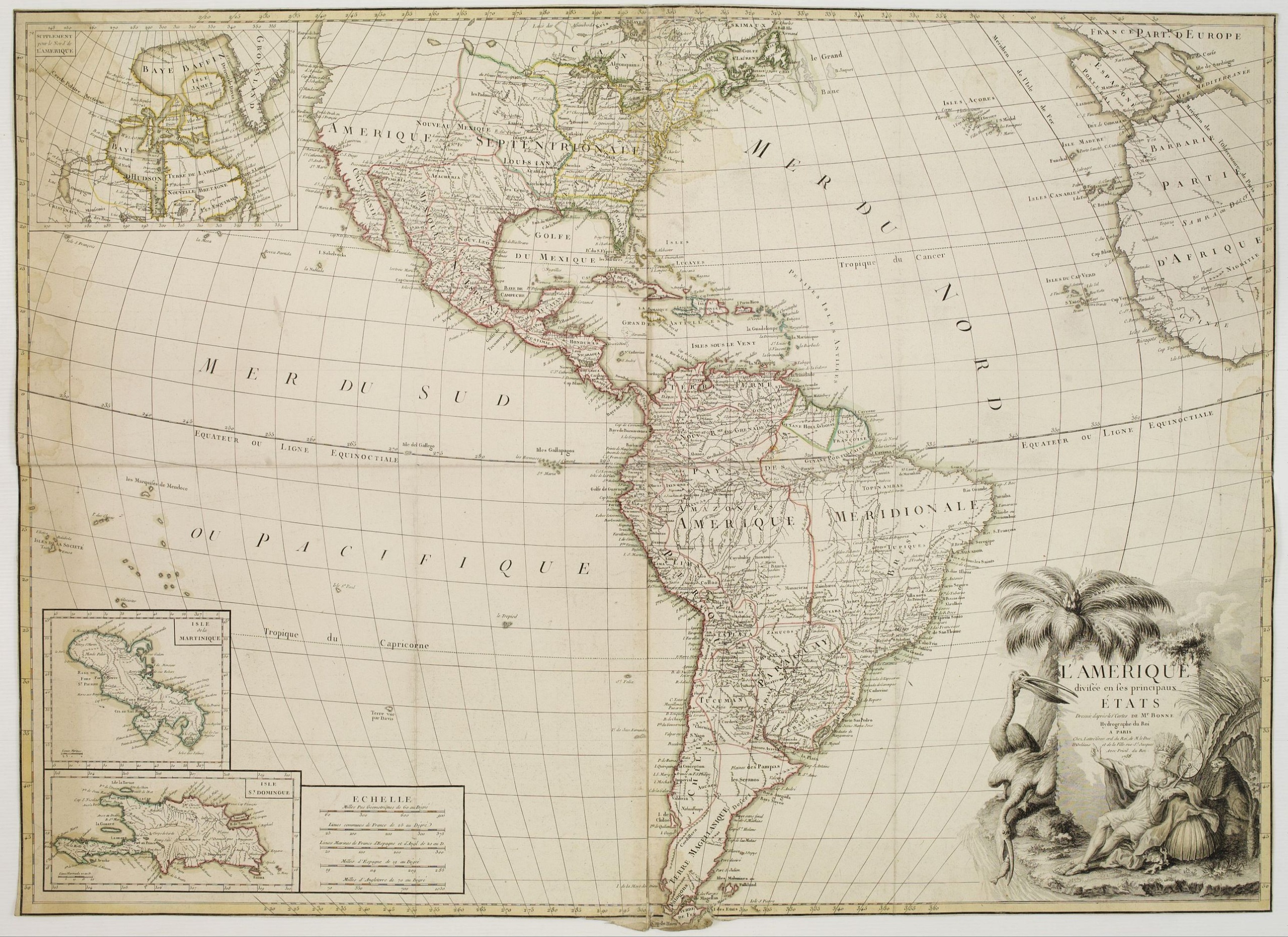
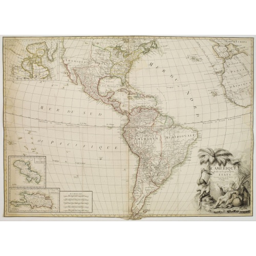
L'Amérique divisée en ses principaux Etats Dressée d'après les Cartes de Mr. Bonne
BuyNow for €5.500
- Maker :
- BONNE, R. / LATTRÉ, J.
- Place :
- Paris
- Date :
- 1788
- Color :
- In original outline colors
- Height mm.:
- 735
- Width mm.:
- 1005
- Condition :
- Some water stains, margins cut close to the plate mark, traces of creases, and a small tear in the lower part affecting ''Tierra del Fuego''.
- Bibliography :
- Not found in any reference book.
- Seller's ref. :
- 62081
This item is offered by Librairie_Loeb-Larocque
See other Items from this seller- Postage
-
Standard Shipping
€0 to France
- Select Country
- Zip/Post Code
- Quantity
€5.500
Description
Rare, wall map of America in 2 sheets, after R. Bonne. With 3 inset maps of Hispaniola, Martinique and Hudson Bay. Beautiful title cartouche depicting a Native American leaning on a shell, under a palm tree, the figure is surrounded by typical elements of the flora and fauna of the continent as a beaver and 2 pelicans.![Venetia. [Venice ]](/uploads/cache/45176-500x500.jpg)
Venetia. [Venice ]
Very rare view of Venice published in the first edition of "Viaggio da Venetia, a Costantinopoli. Per Mare, e per Terra, & infieme quello di Terra Santa. Da Gioseppe Rosaccio con brevita descritto".Several of the maps and plans resemble those in G. F. Camocio's "Isole famose", in particular the maps of the individual Greek islands, among which are Corfu, Crete, Cyprus, together with a map of Palestine and a view of Jerusalem.It is possible that many of the plates may originate from 1590-1597, wh...
€420
Maker : ROSACCIO, Giuseppe
Place : Venice, Giacomo Franco, 1598
Date : 1598
![Boertige reis door Europa. . . [with] Europa volgens de nieuwste verdeeling. . .](/uploads/cache/32642-500x500.jpg)
Boertige reis door Europa. . . [with] Europa volgens de nieuwste verdeeling. . .
Rare illustrated publication including a rare map of Europe as a regal queen with the title "Geheimzinnige toebereidselen tot eene boertige reis door Europa. [...] voorgeleezen in [...] de maatschappij der verdiensten, onder de spreuk: Felix Meritis. / By A. Fokke Simonsz".The book contains a map of Europe (168x2369mm.) engraved by H.Klockhoff and a cartographical curiosity, "Europa volgens de nieuwste verdeeling...", Europe as a regal queen but with an interesting twist and political commentary...
€1.900
Maker : BOHN, F.
Place : Haarlem
Date : 1794
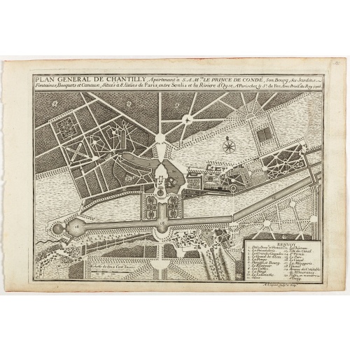
Plan general de Chantilly . . .
Plan of the city of Chantilly, from Nicolas de Fer's "L'Atlas curieux ou le Monde réprésente dans des cartes. "The "Atlas Curieux" is a geographic encyclopedia of images and a celebration of the French Empire under the Sun King, with maps of French possessions in the western hemisphere, maps of France, with detailed views of the grand waterworks at Marly, views of the great palaces and chateaux, views and plans of the Paris Observatory, and samples of military architecture. Issued in six annua...
€60
Maker : DE FER, N.
Place : Paris
Date : 1705
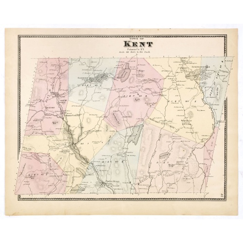
Town of Kent.
Fine lithographed map of the town of Kent. From :"Atlas of New York and vicinity" published by Beers, Ellis & Soule, 95 Maiden Lane, New York.The map provides the names of specific homeowners, as well as information about the occupations and physical locations of the various tradesmen in each village from Beer's famous county atlas "Atlas of New York and vicinity", a documentary record of nineteenth-century life and delightful specimens of American folk art.F. W. Beers, along with other members ...
€90
Maker : DE BEERS, F. W.
Place : New York
Date : 1867
Postage & Shipping
-
Item Location
Terms and conditions - Item Location
- 75013, Ile-de-France, France
- Ships To
- United States, United Kingdom, Albania, Argentina, Armenia, Australia, Austria, Bahamas, Belgium, Bermuda, Bosnia and Herzegowina, Brazil, Bulgaria, Canada, Chile, China, Costa Rica, Denmark, Dominica, Egypt, El Salvador, Finland, France, Germany, Greece, Guatemala, Hong Kong, Hungary, Iceland, India, Italy, Japan, Korea (South), Kuwait, Liechtenstein, Lithuania, Luxembourg, Madagascar, Mexico, Monaco, Morocco, Netherlands, Netherlands Antilles, New Zealand, Norway, Paraguay, Peru, Philippines, Poland, Portugal, Qatar, Reunion, Romania, San Marino, Saudi Arabia, Seychelles, Singapore, Slovenia, South Africa, Spain, Sri Lanka, Suriname, Sweden, Switzerland, Taiwan, Thailand, Tunisia, Turkey, United Arab Emirates, Uruguay, Vietnam
- Pick-ups
- Buyer can pick-up
This item is owned and offered by the seller Librairie_Loeb-Larocque - All items are available for immediate sale, offered subject to prior sale.
Invoices are created by the seller by using our shopping cart or be prepared by the seller the day following the order and are emailed to you.
Items offeres by different sellers are invoiced separately.
Shipping fees are extra. The buyer is responsible for all applicable taxes, including any VAT, customs clearance, import duties, or equivalent costs arriving at the customer's home border. Payment is due on receipt of the invoice. The item(s) are shipped as soon as possible after receipt of your payment.
Before buying please read the complete Terms Conditions of Sale.
- Payment Methods
- Visa, Mastercard, Bank Transfer, American Express, iDEAL, PayPal, Google Pay
- Returns Accepted
- No
Post Message
Feel free to ask the seller a question. Please note that the seller could be located in an area with a different time zone. Our seller will do their best to respond within 24 hours.Post your message below.
Sign in to ask the seller a question.