
ID: 129
Open
Listing ID: #129 has been added to your wishlist.
![Beschrijving van Oud en Nieuw Oost-Indien. Vervattende een Naukeurige en uitvoerige verhandelinge van Nederlands Mogentheyd [...] met meer dan thien honderd en vyftig Prentverbeeldingen verrykt...](/uploads/47258.jpg)
Beschrijving van Oud en Nieuw Oost-Indien. Vervattende een Naukeurige en uitvoerige verhandelinge van Nederlands Mogentheyd [...] met meer dan thien honderd en vyftig Prentverbeeldingen verrykt...
BuyNow for €23.500
- Maker :
- VALENTIJN,
- Place :
- Dordrecht /Amsterdam
- Date :
- 1724-1726
- Color :
- Uncoloured
- Height mm.:
- 370
- Width mm.:
- 235
- Condition :
- 5 volumes in 8 luxury later half leather bindings, incl. 266 plates and maps, including a folding portrait of the author, an allegorical title and engraved dedication leaf with vignette, numerous text illustrations (two full-page), and 9 folding tables.
- Bibliography :
- -
- Seller's ref. :
- 47258
This item is offered by Librairie_Loeb-Larocque
See other Items from this seller- Postage
-
Standard Shipping
€0 to France
- Select Country
- Zip/Post Code
- Quantity
€23.500
Description
"The most comprehensive work on Asia published in Europe during the early colonial period" (Landwehr). The first book to give a comprehensive account in text and illustration, of the peoples, places, and natural history of Indonesia" (Bastin & Brommer).Volume I, part I contains the preliminary matter plus the Philippines and Acapulco;
- volume I, part II covers the Moluccas;
- volume II and volume III, part 1 cover Amboina;
- volume III, part 2 covers Amboina, Celebes, Borneo, and Further India;
- volume IV, part 1 contains Java;
- volume IV, part 2 contains Java, Surratt, China, Formosa, and Valentijn's 1726 voyages;
- volume V, part 1 covers Coromandel, Persia, Malaya, Sumatra, and Ceylon;
- volume V, part 2 covers Malabar, Japan, Cape of Good Hope, and Mauritius.
The book is lavishly illustrated with 266 engraved plates and maps, most double-page or folding, some with several views, a few conjoined, with engraved illustrations in the text, illustrations by F. Ottens, J.C. Philips, J. Goeree, G. Schoute, O. Eliger, D. & W. Jongman, L. Lamsvelt, N.F. Diamaer, and J. Ledeboer, mostly after drawings by M. Balen.
François Valentijn, a native of Dordrecht in Holland, studied at the universities of Leiden and Utrecht. Valentijn lived in the East Indies for a total of 16 years, first employed at the age of 19 by the V.O.C. (i.e., the Vereenigde Oost-Indische Compagnie, or the Dutch East India Company) as minister to the East Indies, and later returning to serve as an army chaplain on an expedition in eastern Java.
He finally returned to his native Dordrecht and produced the Oud en Nieuw Oost-Indiën (1724 1726), a massive work of five parts published in eight volumes and containing over one thousand engraved illustrations and some of the most accurate maps of the Indies of the time. Valentijn probably had access to the V.O.C. s archive of maps and geographic trade secrets, which they had always guarded jealously. The work covers Dutch exploration and commercial ventures in the East Indies and Dutch settlements in China and Japan, parts of the Near and Middle East, the Philippines, Ceylon, and the Cape of Good Hope.
Valentijn includes accounts of the voyages of Abel Tasman in 1642-1643 and of Willem de Vlamingh to the western coast of Australia in 1696-1697. The wealth of fine maps and views include a folding map of Australia showing Tasman's route, the first published view of Tasmania and of Western Australia (Dampier including only coastal profiles), and an especially fine, large "Tabula Indiae Orientalis et regnorum adjacentium", including Australia.
The part includes the earliest views of Tasmania, while the view of Vlamingh consists of the first representation of the black swan (in volume III) with his ship at anchor at the mouth of the Swan.
References: Landwehr (VOC), 467; Cordier (Indosinica), 927-930; Cordier (Japonica), 426-428; Mendelssohn II, 535; Tiele II, 1121; Nissen (ZBI), 4213.; E.M. Beekman, Fugitive Dreams: An Anthology of Dutch Colonial Literature, pp. 55-80; Thomas Suárez, Early Mapping of Southeast Asia, pp. 232-237
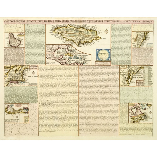
Carte qui contient..Iles & Terres..L'Amerique..Jamaique..
Eight maps on one sheet. From Chatelain's Atlas Historique et Méthodique . Including maps of Bermuda, Jamaica, New England with Long Island, Carolina, Chesapeake and Delaware Bay, Nova Scotia and a map of the Caribbean.
€500
Maker : CHATELAIN, H.
Place : Amsterdam
Date : 1728
-500x500.jpg)
TOMBEAU DU DUC DE BREZE, DANS LA CATHEDRALE DE ROUEN. Dessiné d'après nature par Chapuy. Lith. par Monthelier. Fig. par Bayot.
Original lithography of the tomb of the duke of Brézé, in the cathedral of Rouen. Lithographed by Jules Monthelier (1801-1883) and Adolphe-Jean-Baptist Bayot (Alessandria 1810 - 1866) after a design by Chapuy and printed in Paris by Lemercier, Bernard Cie.
€50
Maker : CHAPUY
Place : Paris
Date : 1844
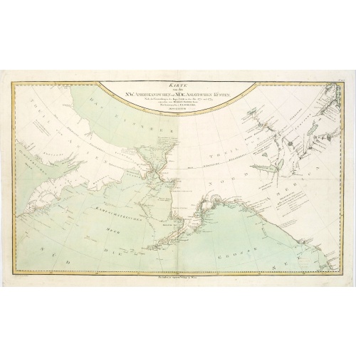
Karte von den N.W. Amerikanischen und N.OE. Asiatischen Kusten nach den Untersuchungen des Kapit. Cook...
A detailed large-scale map showing the Bering Strait, Kamchatka, Alaska and much of North America. While the Russian coastline is shown with reasonable accuracy. Showing tracks of Captain Cook. Prepared by Heinrich Roberts.A German language variant of Cook’s map of his explorations along the northwest coast of America and the northeast coast of Asia. Based upon original work by Cook’s cartographer Henry Roberts. Vancouver Island is missing. Shows several lakes west of Hudson Bay in what is...
€900
Maker : SCHRAEMBL, F.A.
Place : Vienna
Date : 1788
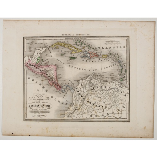
Le Indie Ocidentali ( Antille maggiori e minori, ecc) L'America Centrale . . .
Uncommon map of Central America and the Antilles prepared by Francesco Costantino Marmocchi. Above the map "Geografia Commerciale". From "Il Globo Atlante di carte Geografiche compilate da F.C. Marmocchi per servire di corredo al suu corso di geografia commerciale", with the maps engraved by engraved by Gius. Cattaneo, Campo Antico, C. Poggiali, G. Bonatti, and Ces. Magrini.Marmocchi (Poggibonsi, 1805-Geneva, 1858) was known as a geographer and cartographer. He emigrated to Rome, and later to Co...
€75
Maker : MARMOCCHI, F.C.
Place : Genova, Paolo Rivara fu Giacomo
Date : 1858
Postage & Shipping
-
Item Location
Terms and conditions - Item Location
- 75013, Ile-de-France, France
- Ships To
- United States, United Kingdom, Albania, Argentina, Armenia, Australia, Austria, Bahamas, Belgium, Bermuda, Bosnia and Herzegowina, Brazil, Bulgaria, Canada, Chile, China, Costa Rica, Denmark, Dominica, Egypt, El Salvador, Finland, France, Germany, Greece, Guatemala, Hong Kong, Hungary, Iceland, India, Italy, Japan, Korea (South), Kuwait, Liechtenstein, Lithuania, Luxembourg, Madagascar, Mexico, Monaco, Morocco, Netherlands, Netherlands Antilles, New Zealand, Norway, Paraguay, Peru, Philippines, Poland, Portugal, Qatar, Reunion, Romania, San Marino, Saudi Arabia, Seychelles, Singapore, Slovenia, South Africa, Spain, Sri Lanka, Suriname, Sweden, Switzerland, Taiwan, Thailand, Tunisia, Turkey, United Arab Emirates, Uruguay, Vietnam
- Pick-ups
- No pick-ups
This item is owned and offered by the seller Librairie_Loeb-Larocque - All items are available for immediate sale, offered subject to prior sale.
Invoices are created by the seller by using our shopping cart or be prepared by the seller the day following the order and are emailed to you.
Items offeres by different sellers are invoiced separately.
Shipping fees are extra. The buyer is responsible for all applicable taxes, including any VAT, customs clearance, import duties, or equivalent costs arriving at the customer's home border. Payment is due on receipt of the invoice. The item(s) are shipped as soon as possible after receipt of your payment.
Before buying please read the complete Terms Conditions of Sale.
- Payment Methods
- Visa, Mastercard, Bank Transfer, American Express, iDEAL, PayPal, Google Pay
- Returns Accepted
- No
Post Message
Feel free to ask the seller a question. Please note that the seller could be located in an area with a different time zone. Our seller will do their best to respond within 24 hours.Post your message below.
Sign in to ask the seller a question.
![Beschrijving van Oud en Nieuw Oost-Indien. Vervattende een Naukeurige en uitvoerige verhandelinge van Nederlands Mogentheyd [...] met meer dan thien honderd en vyftig Prentverbeeldingen verrykt...](/uploads/cache/47258-500x500.jpg)