ID: 411
Open
Listing ID: #411 has been added to your wishlist.
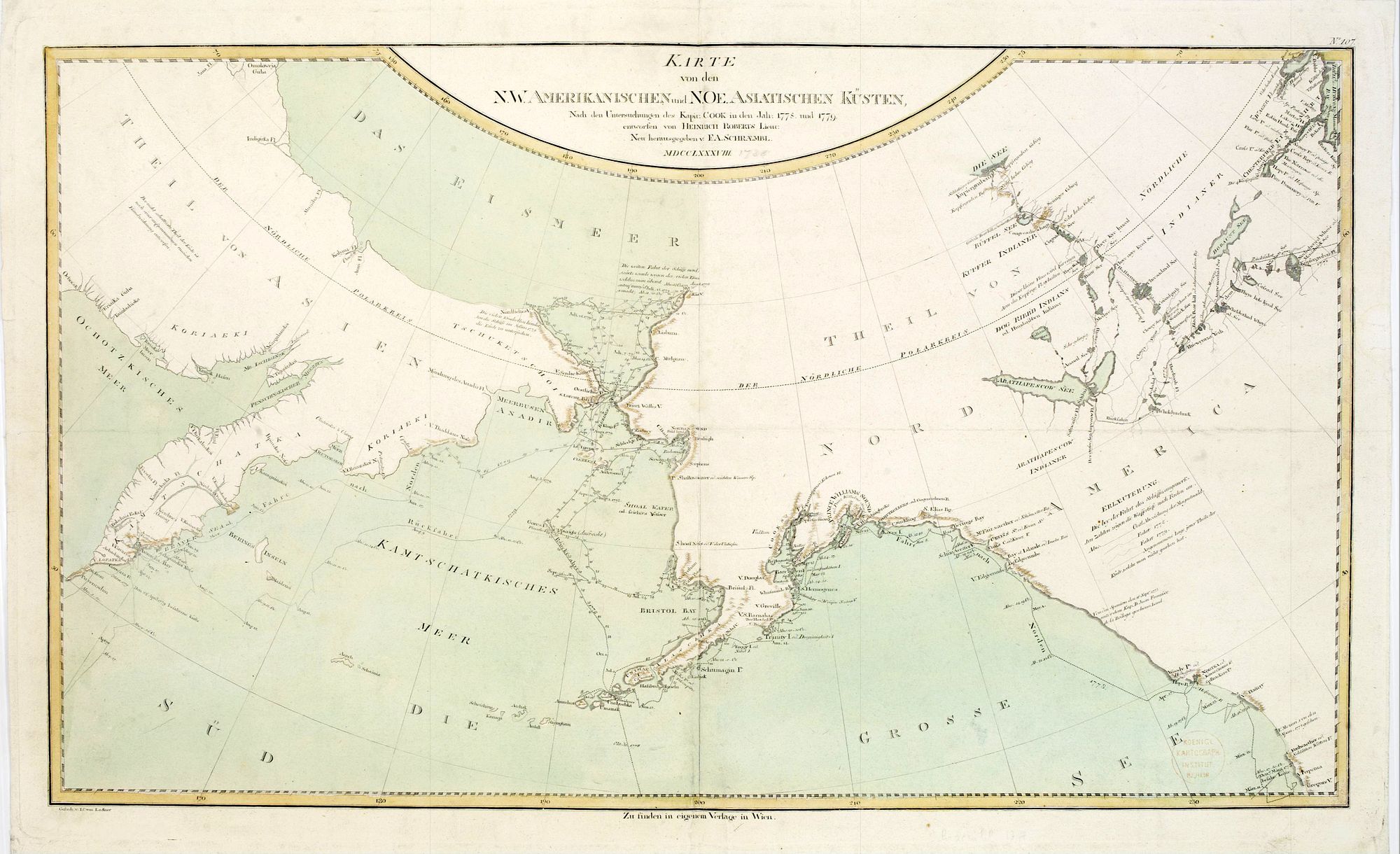
Karte von den N.W. Amerikanischen und N.OE. Asiatischen Kusten nach den Untersuchungen des Kapit. Cook...
BuyNow for €900
- Maker :
- SCHRAEMBL, F.A.
- Place :
- Vienna
- Date :
- 1788
- Color :
- In original outline colors
- Height mm.:
- 390
- Width mm.:
- 664
- Condition :
- Good condition.
- Bibliography :
- -
- Seller's ref. :
- 04805
This item is offered by Librairie_Loeb-Larocque
See other Items from this seller- Postage
-
France
€15 to France
- Select Country
- Zip/Post Code
- Quantity
€900
Description
A detailed large-scale map showing the Bering Strait, Kamchatka, Alaska and much of North America. While the Russian coastline is shown with reasonable accuracy.Showing tracks of Captain Cook. Prepared by Heinrich Roberts.A German language variant of Cook’s map of his explorations along the northwest coast of America and the northeast coast of Asia.
Based upon original work by Cook’s cartographer Henry Roberts. Vancouver Island is missing. Shows several lakes west of Hudson Bay in what is today northwestern Canada. Numerous depth soundings are detailed along the exploration tracks.
In addition to Cook’s work, also notes the explorations of Bodega and the inland discoveries of Hearn, and others. Engraved by I.C. Lackner for the 1788 edition of the "Allgemeiner Grosser Atlas", plate no. 107.
Complete title : Karte von den N.W. Amerikanischen und N.OE. Asiatischen Kusten nach den Untersuchungen des Kapit. Cook in den Jah. 1778 und 1779.
Venise. 1700
Extremely rare panoramic broad sheet panoramic town-view of Venice with underneath in letter press a description of the town's history.The view measures more than 1 meter. The foreground is animated with a great variety of sailing vessels.The printer's address is dated 1699, but the tile has the date 1700. Most likely, Jaillot published the view to celebrate the turn of the century!
€20.000
Maker : JAILLOT, H.
Place : Paris
Date : 1699
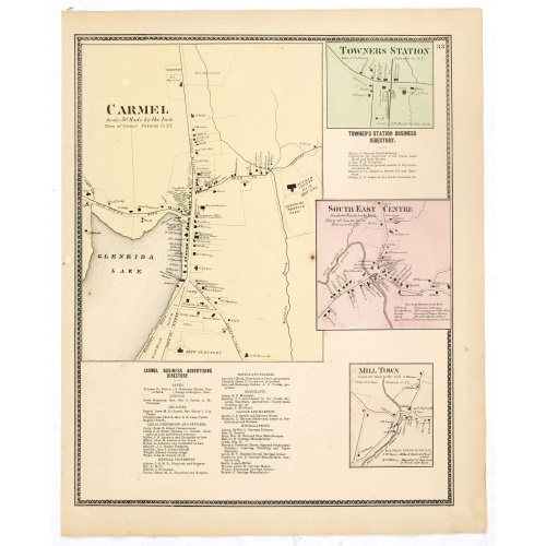
Town of Carmel / Towners Station / South East Centre / Mill Town.
Fine lithographed map of the town of Carmel / Towners Station / South East Centre / Mill Town. From "Atlas of New York and vicinity" published by Beers, Ellis & Soule, 95 Maiden Lane, New York.The map provides the names of specific homeowners, as well as information about the occupations and physical locations of the various tradesmen in each village from Beer's famous county atlas "Atlas of New York and vicinity," "a documentary record of nineteenth-century life and delightful specimens of Ame...
€80
Maker : DE BEERS, F. W.
Place : New York
Date : 1867
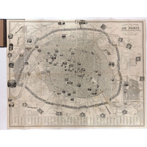
Nouveau plan illustré de la ville de Paris . . .
Fine plan of Paris, engraved by Taylor. "With the complete system of its fortifications and strong detached". Adorned with many vignettes engraved with monuments of Paris.
€900
Maker : VUILLEMIN, A.
Place : Paris
Date : 1847

West India Islands.
Map of the West Indies, published by "The London Printing and Publishing Company". Drawn and engraved by John Rapkin.
€75
Maker : RAPKIN, J.
Place : London
Date : 1854
Postage & Shipping
-
Item Location
Terms and conditions - Item Location
- 75013, Ile-de-France, France
- Ships To
- United States, United Kingdom, Albania, Argentina, Armenia, Australia, Austria, Bahamas, Belgium, Bermuda, Bosnia and Herzegowina, Brazil, Bulgaria, Canada, Chile, China, Costa Rica, Denmark, Dominica, Egypt, El Salvador, Finland, France, Germany, Greece, Guatemala, Hong Kong, Hungary, Iceland, India, Italy, Japan, Korea (South), Kuwait, Liechtenstein, Lithuania, Luxembourg, Madagascar, Mexico, Monaco, Morocco, Netherlands, Netherlands Antilles, New Zealand, Norway, Paraguay, Peru, Philippines, Poland, Portugal, Qatar, Reunion, Romania, San Marino, Saudi Arabia, Seychelles, Singapore, Slovenia, South Africa, Spain, Sri Lanka, Suriname, Sweden, Switzerland, Taiwan, Thailand, Tunisia, Turkey, United Arab Emirates, Uruguay, Vietnam
- Pick-ups
- Buyer can pick-up
This item is owned and offered by the seller Librairie_Loeb-Larocque - All items are available for immediate sale, offered subject to prior sale.
Invoices are created by the seller by using our shopping cart or be prepared by the seller the day following the order and are emailed to you.
Items offeres by different sellers are invoiced separately.
Shipping fees are extra. The buyer is responsible for all applicable taxes, including any VAT, customs clearance, import duties, or equivalent costs arriving at the customer's home border. Payment is due on receipt of the invoice. The item(s) are shipped as soon as possible after receipt of your payment.
Before buying please read the complete Terms Conditions of Sale.
- Payment Methods
- Visa, Mastercard, Bank Transfer, iDEAL, PayPal, Google Pay
- Returns Accepted
- No
Post Message
Feel free to ask the seller a question. Please note that the seller could be located in an area with a different time zone. Our seller will do their best to respond within 24 hours.Post your message below.
Sign in to ask the seller a question.