
ID: 220
Open
Listing ID: #220 has been added to your wishlist.
.jpg)
Holland & Belgium.
BuyNow for $110
- Maker :
- ARROWSMITH, John
- Place :
- London, 1839
- Date :
- 1839
- Color :
- In original outline colors
- Height mm.:
- 585
- Width mm.:
- 475
- Condition :
- In very good condition. With minor markings only.
- Bibliography :
- -
- Seller's ref. :
- 38924
This item is offered by Paulus_Swaen_Old_Maps
See other Items from this seller- Postage
-
Europe
$34 to France
- Select Country
- Zip/Post Code
- Quantity
$110
Description
An attractive steel engraved map of Holland and Belgium. Map flanked by France and Prussia. Duchy of Luxembourg included. Many place names and physical features shown. 4 mileage scales given.The Arrowsmith family members were among the most respected and influential cartographers of the nineteenth century. Taken from 'The London Atlas of Universal Geography…'
John Arrowsmith (1790-1873) joined his uncle, Aaron Arrowsmith in mapmaking in London in 1810. Upon the death of his uncle in 1823, the business was carried on by Aaron's two sons, Samuel and Aaron. In 1839, John took over the business. This atlas was first published in 1834.
His maps were very numerous, and their neatness and finished style gained John a very extensive reputation.
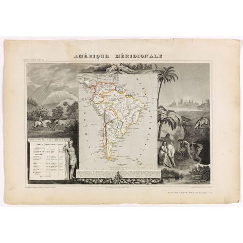
Amérique Méridionale.
Map of South America.Lovely map from one of the last decorative atlases of the nineteenth century.The rather simple map is framed by horses, Indians, jaguars, tapirs, and mining, as well as personifications of the rivers Amazon and La Plata at the top of the map. Victor Levasseur's "Atlas National Illustré" and "Atlas Universel Illustré" are among the last great decorative atlases published. This map comes from the Atlas National Illustré.
$90
Maker : LEVASSEUR, V.
Place : Paris, A. Combette
Date : 1852
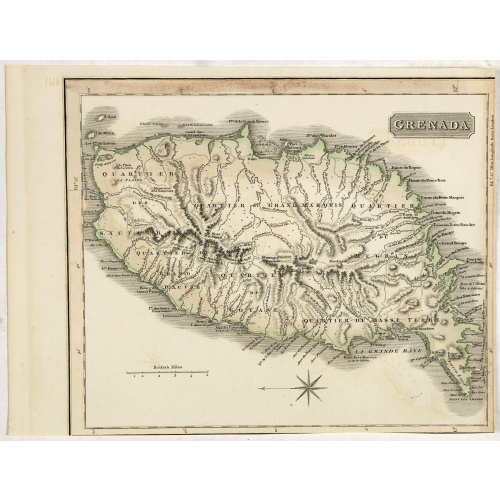
Grenada.
A delightfully detailed map the West Indian island Grenada by John Thomson. The map displays excellent detail concerning roads, rivers, towns, bays, harbours and other interesting topographical details.Thomson (1777-c1840) was a Scottish cartographer from Edinburgh, celebrated for his 1817 New General Atlas, published by himself in Edinburgh, John Cumming in Dublin, and Baldwin, Cradock, and Joy in London.
$50
Maker : THOMSON, J.
Place : Edenburgh
Date : 1821
![[How the Inca nobility are buried] / [Bridge of Huaynacapaco]](/uploads/cache/41094-(1)-500x500.jpg)
[How the Inca nobility are buried] / [Bridge of Huaynacapaco]
Two engravings. [470] The funeral of an Inca king was a ceremony of great splendor. After digging a large pit, the Indians would decorate the corpse with gold and silver then bury it with many fine ornaments, along with good food and wine to help it on its way into the next world. Benzoni so described the burial of Huayna-Capac, whose grave he said was on the border of the province of Quito. When the Spanish first went to Peru, they discovered and pillaged many such graves.[469] Much of Ecuador ...
$80
Maker : GOTTFRIED, J.L. / DE BRY.
Place : Frankfurt, M.Merian
Date : 1633

Marine parallel rulers in brass.
Very fine marine parallel rulers in brass. The parallel ruler is the oldest and most traditional way to measure and trace routes and bearings. The principle is simple: the ruler is placed on the road to be measured and then, like a pantograph, the other part of the ruler is placed on one of the declination roses on the map to determine the angle. They are, essentially, two straight-edges hinged so that they maintain the same angle. By alternating the moving edge, and securely holding down the no...
$1.500
Maker : ANONYMOUS
Place : Paris
Date : ca. 1880
Postage & Shipping
-
Item Location
Terms and conditions - Item Location
- Amsterdam, , Netherlands
- Ships To
- United States, United Kingdom, Albania, Argentina, Armenia, Australia, Azerbaijan, Bahamas, Belgium, Bermuda, Cambodia, Canada, Chile, China, Croatia, Cyprus, Czech Republic, Denmark, Estonia, Finland, France, Germany, Gibraltar, Greece, Greenland, Guatemala, Hong Kong, Iceland, India, Indonesia, Israel, Italy, Japan, Latvia, Lithuania, Luxembourg, Malta, Mexico, Monaco, Netherlands, Norway, Singapore, Spain, Sweden, Switzerland, Turkey
- Pick-ups
- No pick-ups
This item is owned and offered by the seller Paulus_Swaen_Old_Maps - All items are available for immediate sale, offered subject to prior sale.
Invoices are created by the seller by using our shopping cart or be prepared by the seller the day following the order and are emailed to you.
Items offeres by different sellers are invoiced separately.
Shipping fees are extra. The buyer is responsible for all applicable taxes, including any VAT, customs clearance, import duties, or equivalent costs arriving at the customer's home border. Payment is due on receipt of the invoice. The item(s) are shipped as soon as possible after receipt of your payment.
Before buying please read the complete Terms Conditions of Sale.
- Payment Methods
- Payment Simulator, Visa, Mastercard, Bank Transfer, PayPal
- Returns Accepted
- No
Post Message
Feel free to ask the seller a question. Please note that the seller could be located in an area with a different time zone. Our seller will do their best to respond within 24 hours.Post your message below.
Sign in to ask the seller a question.
-500x500.jpg)
![Cordelirs in Franckr. [France].](/uploads/cache/13811-500x500.jpg)