ID: 404
Open
Listing ID: #404 has been added to your wishlist.
![[Collective suicide under Spanish rule.]](/uploads/40480.jpg)
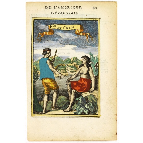
[Collective suicide under Spanish rule.]
BuyNow for €80
- Maker :
- GOTTFRIED, J.L. / DE BRY.
- Place :
- Frankfurt, M.Merian
- Date :
- 1633
- Color :
- Uncoloured
- Height mm.:
- 165
- Width mm.:
- 195
- Condition :
- Copper plate engraving on text sheet. Paper lightly browned as usual, right margin slightly cropped, stains and soling to margins small holes to text etc.
Size of sheet : 345 x 217 mm. German text. - Bibliography :
- -
- Seller's ref. :
- 40480
This item is offered by Librairie_Loeb-Larocque
See other Items from this seller- Postage
-
France
€15 to France
- Select Country
- Zip/Post Code
- Quantity
€80
Description
The natives of Hispaniola, who saw no end to the fearful oppression of Spanish rule, preferred death. So many, devoid of all hope, went into the woods to kill their children and hang themselves.After taking certain natural poisons, the women followed their husbands to death by means of the noose.
Others threw themselves down mountains, jumped into the sea or into rivers, while some died by self-imposed starvation or even stabbed themselves to death with razor sharp stone knives:
In 1631 Johann Ludwig Gottfried, inherited the Theodor De Bry’s publishing firm, among the illustrated accounts of the expeditions of Magellan, Columbus, Vespucci, Cortes, Balboa, Raleigh, Drake, Smith, and many others.
Gottfried issued together with Matthaeus Merian a one-volume condensation "Newe Welt Vnd Americanische Historien/ Jnhaltende Warhafftige vnd volkommene Beschreibungen Aller West-Jndianischen Landschafften..." that used many of the original copper plates and supplemented them with new ones of more recent voyages. The book was published by Matthaeus Merian. The work was reprinted in 1655 / 1657.
![De Bello Belgico decades duae ab excessu... [including lion map]](/uploads/cache/07603-500x500.jpg)
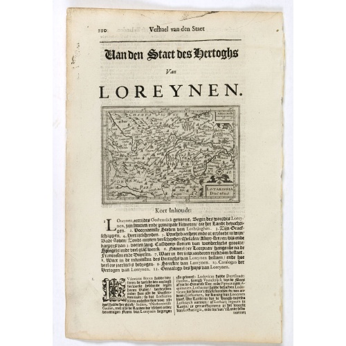
De Bello Belgico decades duae ab excessu... [including lion map]
Included in Famiani Stradae Romani è Societate Jesu de Bello Belgico Decas duae... .Published by Johann Godfried Martin Schönwetter. The book was first published in 1651 and re-published in 1699. The binding is a fine German blind-tooled pigskin, clamps wanting. Fair amount of pages has the usual browning. Copy is somewhat used but altogether very fine. Specially the folding historical engravings are of a high standard.The Bello Belgico , written by Famianus Strada (1572-1649), Jesuit and teac...
$3.500
Maker : STRADA
Place : Frankfurt am Main, Schönwetter
Date : 1699
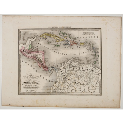
Le Indie Ocidentali ( Antille maggiori e minori, ecc) L'America Centrale . . .
Uncommon map of Central America and the Antilles prepared by Francesco Costantino Marmocchi. Above the map "Geografia Commerciale". From "Il Globo Atlante di carte Geografiche compilate da F.C. Marmocchi per servire di corredo al suu corso di geografia commerciale", with the maps engraved by engraved by Gius. Cattaneo, Campo Antico, C. Poggiali, G. Bonatti, and Ces. Magrini.Marmocchi (Poggibonsi, 1805-Geneva, 1858) was known as a geographer and cartographer. He emigrated to Rome, and later to Co...
€75
Maker : MARMOCCHI, F.C.
Place : Genova, Paolo Rivara fu Giacomo
Date : 1858

Map of Atlantic City to Hackney's Famous Garden of Sea Food . . .
A mid 1950s brochure for the famous Atlantic City Seafood Restaurant - 'Hackneys'. One side proclaims that "All Roads lead to Hackney's". It shows a nice plan of Atlantic City in NJ. Highlighted in red are the famous Boardwalk, Pacific, Atlantic, Albany and Mediterranean Avenues plus Absecon Boulevard, and all roads that lead off them.Other major thoroughfares and roads are shown, together with the Airport and bus and car route. Famous piers are in bold, plus there are small illustrations of sea...
€50
Maker : ANONYMOUS.
Place : New Jersey
Date : 1954

Town of South East.
Fine lithographed map of the town of South East. From : "Atlas of New York and vicinity" published by Beers, Ellis & Soule, 95 Maiden Lane, New York.The map provides the names of specific homeowners, as well as information about the occupations and physical locations of the various tradesmen in each village from Beer's famous county atlas "Atlas of New York and vicinity, a documentary record of nineteenth-century life and delightful specimens of American folk art."F. W. Beers, along with other m...
€90
Maker : DE BEERS, F.W.
Place : New York, 1867
Date : 1867
Postage & Shipping
-
Item Location
Terms and conditions - Item Location
- 75013, Ile-de-France, France
- Ships To
- United States, United Kingdom, Albania, Argentina, Armenia, Australia, Austria, Bahamas, Belgium, Bermuda, Bosnia and Herzegowina, Brazil, Bulgaria, Canada, Chile, China, Costa Rica, Denmark, Dominica, Egypt, El Salvador, Finland, France, Germany, Greece, Guatemala, Hong Kong, Hungary, Iceland, India, Italy, Japan, Korea (South), Kuwait, Liechtenstein, Lithuania, Luxembourg, Madagascar, Mexico, Monaco, Morocco, Netherlands, Netherlands Antilles, New Zealand, Norway, Paraguay, Peru, Philippines, Poland, Portugal, Qatar, Reunion, Romania, San Marino, Saudi Arabia, Seychelles, Singapore, Slovenia, South Africa, Spain, Sri Lanka, Suriname, Sweden, Switzerland, Taiwan, Thailand, Tunisia, Turkey, United Arab Emirates, Uruguay, Vietnam
- Pick-ups
- Buyer can pick-up
This item is owned and offered by the seller Librairie_Loeb-Larocque - All items are available for immediate sale, offered subject to prior sale.
Invoices are created by the seller by using our shopping cart or be prepared by the seller the day following the order and are emailed to you.
Items offeres by different sellers are invoiced separately.
Shipping fees are extra. The buyer is responsible for all applicable taxes, including any VAT, customs clearance, import duties, or equivalent costs arriving at the customer's home border. Payment is due on receipt of the invoice. The item(s) are shipped as soon as possible after receipt of your payment.
Before buying please read the complete Terms Conditions of Sale.
- Payment Methods
- Visa, Mastercard, Bank Transfer, American Express, iDEAL, PayPal, Google Pay
- Returns Accepted
- No
Post Message
Feel free to ask the seller a question. Please note that the seller could be located in an area with a different time zone. Our seller will do their best to respond within 24 hours.Post your message below.
Sign in to ask the seller a question.
![[Collective suicide under Spanish rule.]](/uploads/cache/40480-500x500.jpg)