ID: 408
Open
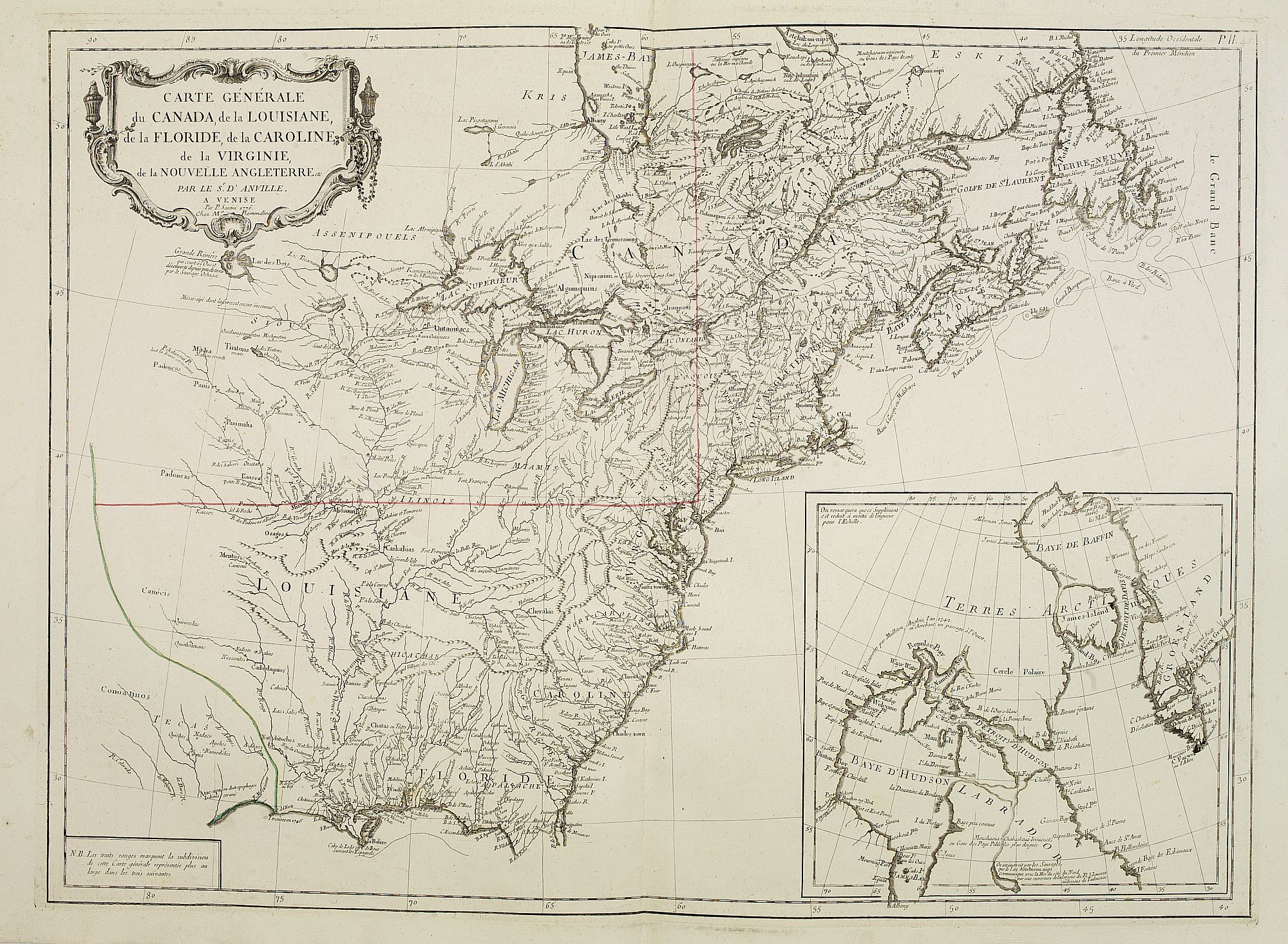
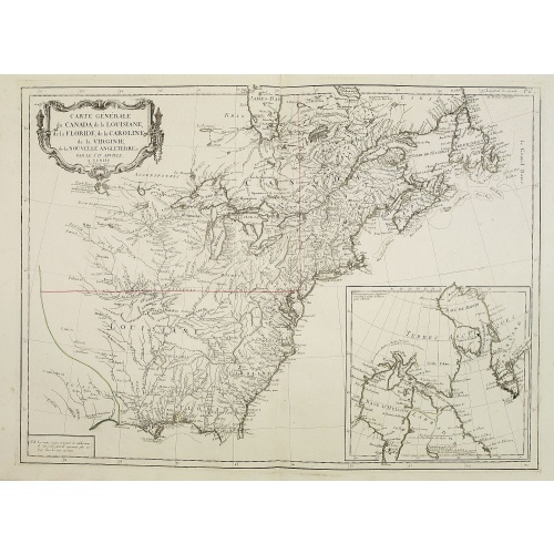
Carte Générale du Canada, de la Louisiane, de la Floride, de la Caroline..
BuyNow for €750
- Maker :
- SANTINI, P. / REMONDINI, M.
- Place :
- Venice
- Date :
- 1784
- Color :
- In original outline colors
- Height mm.:
- 479
- Width mm.:
- 655
- Condition :
- Minor marginal spotting. Else very good condition.
- Bibliography :
- -
- Seller's ref. :
- 24967
This item is offered by Librairie_Loeb-Larocque
See other Items from this seller- Postage
-
France
€15 to France
- Select Country
- Zip/Post Code
- Quantity
€750
Description
Map of the eastern part of the United States and Canada. With inset map of Hudson and Baffin bays. in the lower right corner.Venetian edition of d'Anville's map, from "Atlas Universel" printed in 1776-84.
Noteworthy topographical detail is shown, with particular focus on the Great Lakes. Lake Superior is shown attached to a convoluted river system reaching across the continent reminiscent of the Riviere Longue of Baron Lahontan's memoirs.
On the Gulf Coast the region of Tecas (Texas) is named with a nearby note about the Atac-apa tribe of Indians, who are noted as Antrophages (Cannibals) and Indiens errans.
The map was prepared by the Venetian cartographer and publisher François (Père) Santini and first published in Santini's 'Atlas Universel dresse sur les meuilleures cartes modernes 1776.'
Santini collaborated with Janvier and gives credit to him on most of his maps. The atlas is effectively an Italian copy of the Robert de Vaugondy 'Atlas Universel'.
In 1784 Santini sold the plates to M. Remondini, whose name appears on this particular example - indicating that this is the second state of the map.
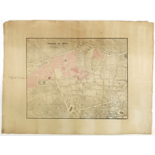
Quartier de Tivoli Nouveaux pereements de Rues.
Plan of the center of Paris showing Tivoli district with Madalene and Clichy. Lithography and pen and ink. Drawn in are the planned workshop of Serrurerie Théophile Mignon, 30 rue de la Bienfaisance.
€75
Maker : ANNONYMOUS
Place : Paris
Date : ca.1835
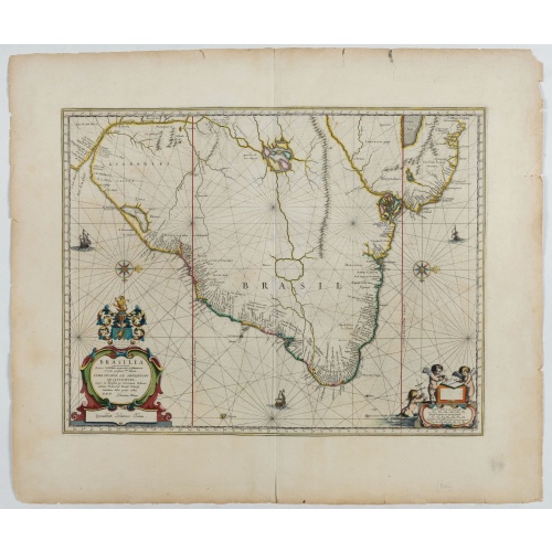
Brasilia.
Fine copy of this map by Krystof Arciszewski, a Polish general who worked for the Dutch West Indian Company. The map perpetuates various myths including the Parime Lago , although it is generally more accurate than its predecessors. Orientated with west to the top. Including the mouth of the Amazon.
€700
Maker : BLAEU, J.
Place : Amsterdam
Date : 1647
![Parisius & Maguncia. [Paris & Munich] Folio XXXIX](/uploads/cache/29718-500x500.jpg)
Parisius & Maguncia. [Paris & Munich] Folio XXXIX
Imaginary view of Paris and on verso Munich : however the earliest obtainable views of this period.In the forground a large vessel, who was the symbol of the powerful corporate body of the Marchands de l'eau, and is dating back to the Middle Ages. The city motto, "Fluctuat nec mergitur" ("It is beaten by the waves without being submerged") is equally a reference to this vessel. The first mention of coat of arms of Paris with the vessel appears as early as 1190 when Philippe Augustus gave the des...
€900
Maker : SCHEDEL, H.
Place : Nuremberg
Date : 12 July 1493
![A Map of the United States and Canada, New-Scotland, New-Brunswick and New-Foundland ... [together with] A Map of the West-Indies and of the Mexican-Gulph...](/uploads/cache/39235-500x500.jpg)
A Map of the United States and Canada, New-Scotland, New-Brunswick and New-Foundland ... [together with] A Map of the West-Indies and of the Mexican-Gulph...
A Map of the United States and Canada, New-Scotland, New-Brunswick and New-Foundland / Carte des Etats Unis, avec Le Canada, la Nouvelle Ecosse, le Nouveau Brunswick & Terre-Neuve. Dressée par LAPIE, Capitaine-Ingénieur-Géographe. Publiée par P.A.F.TARDIEU, Graveur, Editeur propriétaire a Paris. Déposée à la Bibliothèque Imperiale, le 10 Juin 1806. [together with]A Map of the West-Indies and of the Mexican-Gulph / Carte des Indes Occidentales et du Golfe du Mexique. Dressée par LAPIE, ...
€5.000
Maker : P.A.F. TARDIEU
Place : Paris
Date : 1806
Postage & Shipping
-
Item Location
Terms and conditions - Item Location
- 75013, Ile-de-France, France
- Ships To
- United States, United Kingdom, Albania, Argentina, Armenia, Australia, Austria, Bahamas, Belgium, Bermuda, Bosnia and Herzegowina, Brazil, Bulgaria, Canada, Chile, China, Costa Rica, Denmark, Dominica, Egypt, El Salvador, Finland, France, Germany, Greece, Guatemala, Hong Kong, Hungary, Iceland, India, Italy, Japan, Korea (South), Kuwait, Liechtenstein, Lithuania, Luxembourg, Madagascar, Mexico, Monaco, Morocco, Netherlands, Netherlands Antilles, New Zealand, Norway, Paraguay, Peru, Philippines, Poland, Portugal, Qatar, Reunion, Romania, San Marino, Saudi Arabia, Seychelles, Singapore, Slovenia, South Africa, Spain, Sri Lanka, Suriname, Sweden, Switzerland, Taiwan, Thailand, Tunisia, Turkey, United Arab Emirates, Uruguay, Vietnam
- Pick-ups
- No pick-ups
This item is owned and offered by the seller Librairie_Loeb-Larocque - All items are available for immediate sale, offered subject to prior sale.
Invoices are created by the seller by using our shopping cart or be prepared by the seller the day following the order and are emailed to you.
Items offeres by different sellers are invoiced separately.
Shipping fees are extra. The buyer is responsible for all applicable taxes, including any VAT, customs clearance, import duties, or equivalent costs arriving at the customer's home border. Payment is due on receipt of the invoice. The item(s) are shipped as soon as possible after receipt of your payment.
Before buying please read the complete Terms Conditions of Sale.
- Payment Methods
- Visa, Mastercard, Bank Transfer, iDEAL, PayPal
- Returns Accepted
- No
Post Message
Feel free to ask the seller a question. Please note that the seller could be located in an area with a different time zone. Our seller will do their best to respond within 24 hours.Post your message below.
Sign in to ask the seller a question.