ID: 371
Open
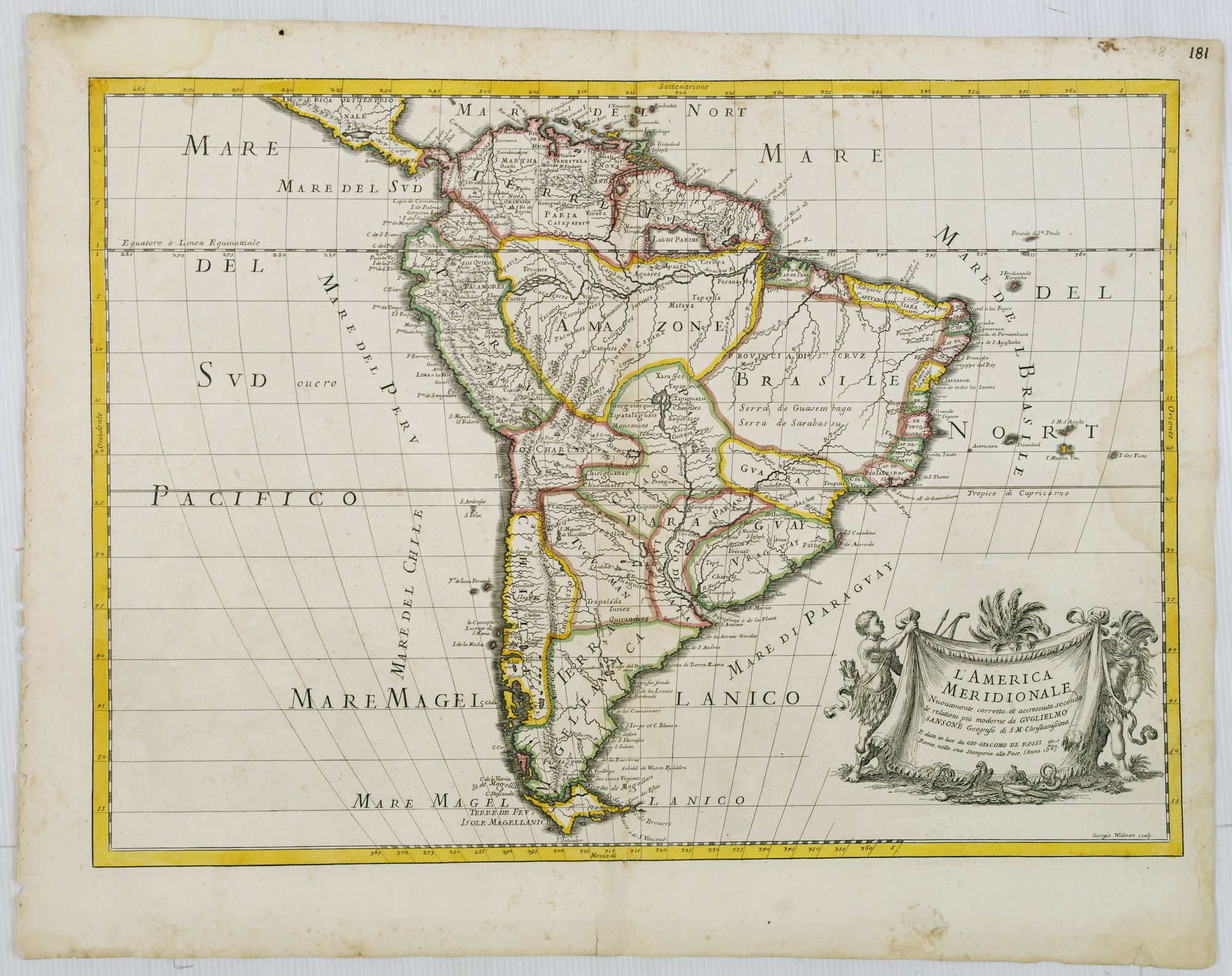
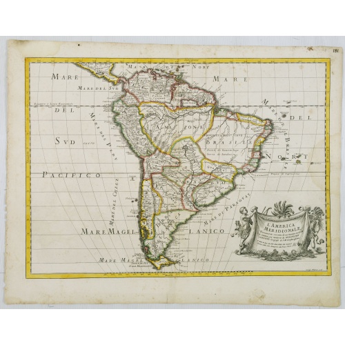
L'America Meridionale . . .
BuyNow for €900
- Maker :
- ROSSI, G.G.
- Place :
- Rome
- Date :
- 1687
- Color :
- In original outline colors
- Height mm.:
- 394
- Width mm.:
- 550
- Condition :
- A dark impression. Marginal light staining and age-toning of paper. A larger water stain in right hand part affecting the engraved area.
- Bibliography :
- -
- Seller's ref. :
- 26609
This item is offered by Librairie_Loeb-Larocque
See other Items from this seller- Postage
-
France
€15 to France
- Select Country
- Zip/Post Code
- Quantity
€900
Description
The second edition of Rossi's map of South America, based upon Sanson's map, but with revised Italian nomenclature. From his 'Mercurio Geografico...'. The engraver was Giorgio Widman.
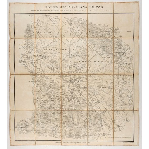
Carte des environs de Pau. . .
Folding map of Pau and its surroundings, being a reduced version of the map by Comte Dulong de Rosnay and engraved by Nicolas Delamare and published by Lafon.
€75
Maker : VCOMTE DULONG DE ROSNAY
Place : Pau, Lafon
Date : 1840-1850

In einem Todt wollen alle zu Ritter werden.
A very nice view of a dead lion, surrounded by rabbits and in the background a French castle. With a verse in two languages underneath the picture. "In einem Todt, nicht ohn geferdn, wollen alle zu Ritter werdn: Viel Hasen man umh den Löwen find, wol dem, der sich selbst überwindt."The poet and topographer from Comothau, Daniel Meisner (1585-1625), started his first publication entitled Thesaurus Philo-Politicus in Frankfurt in 1623, initially in parts, each one containing about fifty plans. ...
€70
Maker : MEISNER, D.
Place : Frankfurt
Date : 1623-1678

Die Vereinigten Staaten von Nord Amerika..
Uncommon map of the east coast of North America, including the Great Lakes area. To the right inset map of New Foundland. After the map by William Faden of 1783. With color-key.
€500
Maker : MARIANUS, J.
Place : Germany, 1790
Date : 1790
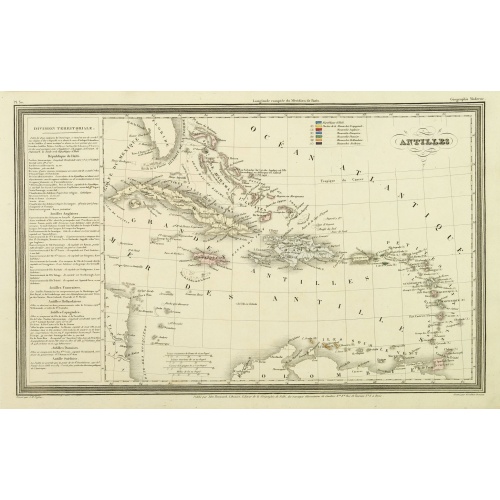
Antilles.
Finely engraved map of the Caribbean, with a color key to Spanish, English, French, Danish, Dutch and Swedish possessions, prepared by A.H.Dufour and engraved by Giraldon-Bovinet. Published by Jules Renouard in his uncommon atlas "Le globe Atlas classique Universel de géographie ancienne et moderne, pour servir a l'étude de la géographie et de l'histoire dressé par M. A.H.Dufour, Et revu par M.Jomard".To the left- "Tableau statistique", giving details on geographical, statistical and economi...
€75
Maker : DUFOUR, A.H.
Place : Paris, Jules Renouard
Date : ca. 1840
Postage & Shipping
-
Item Location
Terms and conditions - Item Location
- 75013, Ile-de-France, France
- Ships To
- United States, United Kingdom, Albania, Argentina, Armenia, Australia, Austria, Bahamas, Belgium, Bermuda, Bosnia and Herzegowina, Brazil, Bulgaria, Canada, Chile, China, Costa Rica, Denmark, Dominica, Egypt, El Salvador, Finland, France, Germany, Greece, Guatemala, Hong Kong, Hungary, Iceland, India, Italy, Japan, Korea (South), Kuwait, Liechtenstein, Lithuania, Luxembourg, Madagascar, Mexico, Monaco, Morocco, Netherlands, Netherlands Antilles, New Zealand, Norway, Paraguay, Peru, Philippines, Poland, Portugal, Qatar, Reunion, Romania, San Marino, Saudi Arabia, Seychelles, Singapore, Slovenia, South Africa, Spain, Sri Lanka, Suriname, Sweden, Switzerland, Taiwan, Thailand, Tunisia, Turkey, United Arab Emirates, Uruguay, Vietnam
- Pick-ups
- Buyer can pick-up
This item is owned and offered by the seller Librairie_Loeb-Larocque - All items are available for immediate sale, offered subject to prior sale.
Invoices are created by the seller by using our shopping cart or be prepared by the seller the day following the order and are emailed to you.
Items offeres by different sellers are invoiced separately.
Shipping fees are extra. The buyer is responsible for all applicable taxes, including any VAT, customs clearance, import duties, or equivalent costs arriving at the customer's home border. Payment is due on receipt of the invoice. The item(s) are shipped as soon as possible after receipt of your payment.
Before buying please read the complete Terms Conditions of Sale.
- Payment Methods
- Visa, Mastercard, Bank Transfer, American Express, iDEAL, PayPal, Google Pay
- Returns Accepted
- No
Post Message
Feel free to ask the seller a question. Please note that the seller could be located in an area with a different time zone. Our seller will do their best to respond within 24 hours.Post your message below.
Sign in to ask the seller a question.