ID: 244
Open
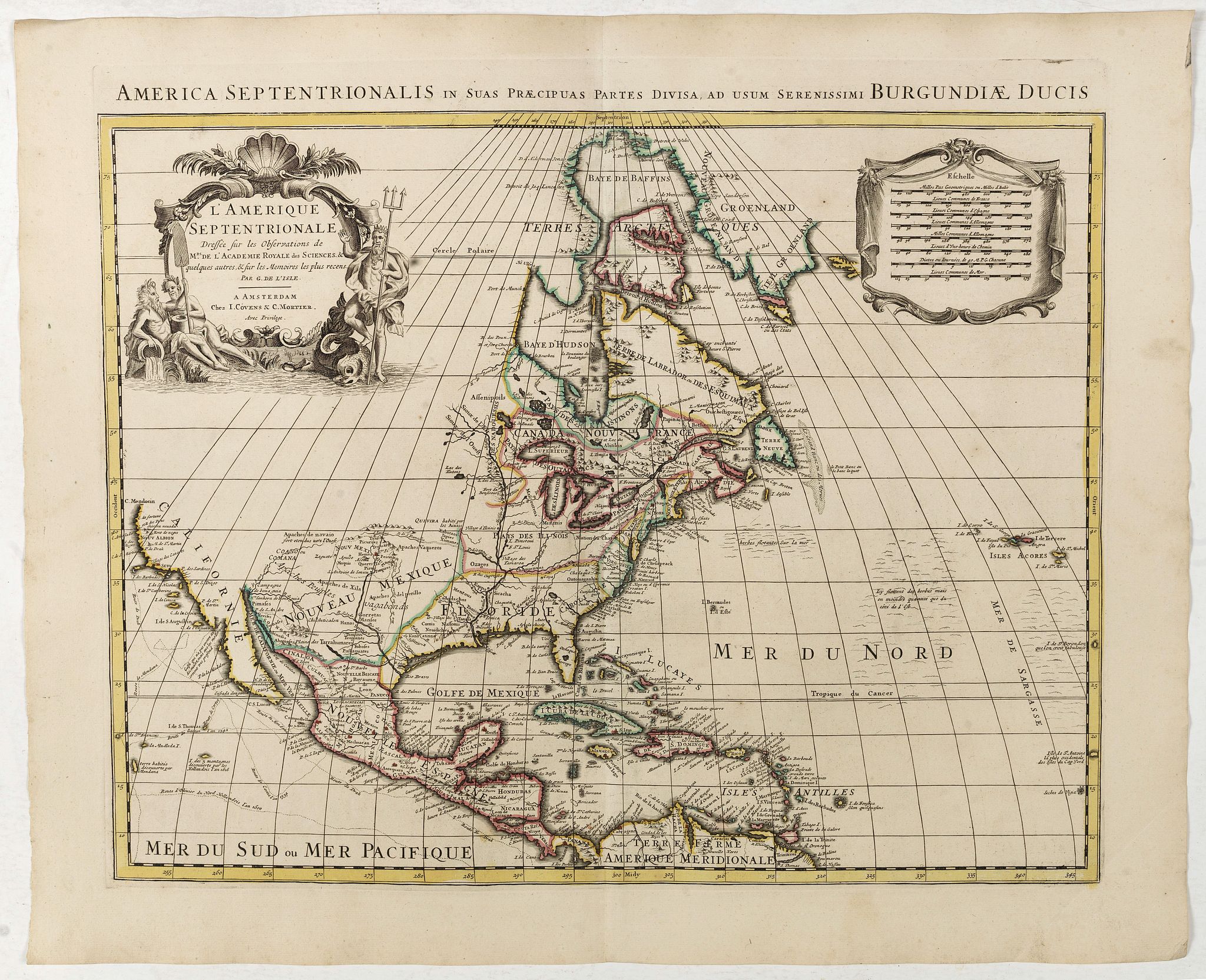
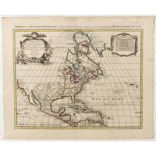
L'Amerique septentrionale, Dressée sur les memoires les plus recens. . .
BuyNow for $900
- Maker :
- COVENS, J. / MORTIER, C.
- Place :
- Amsterdam
- Date :
- 1739
- Color :
- Original color
- Height mm.:
- 447
- Width mm.:
- 578
- Condition :
- Printed on heavy paper. A good and dark impression. In good condition.
- Bibliography :
- Tooley, the continent 4.
- Seller's ref. :
- 43309
This item is offered by Paulus_Swaen_Old_Maps
See other Items from this seller- Postage
-
Europe
$34 to France
- Select Country
- Zip/Post Code
- Quantity
$900
Description
A very detailed map extending from Hudsons Bay to Panama, and including the West Indies. The map is a later copy of Guillaume de L'Isle's foundation map of North America, originally prepared in 1700.The de L'Isle was one of the earliest maps to restore the peninsula form for California, and has a much improved outline for the Great Lakes and Mississippi valley.
The map shows select towns and cities, forts, Indian villages and tribal territory and relief.
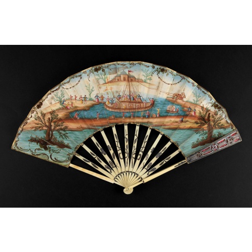
A folding fan showing a nautical festival, ca. 1770.
Folded fan, painted in gouache a ship pulled by two horses. On board, a large company, among others joins them while fishermen watch the scene.Reverse painted with an exotic flower. Monogram "SK" on the left.The ivory frame is engraved with flowers enhanced with silver foil.
$1.500
Maker : ANONYMOUS
Place : France
Date : ca. 1770
-500x500.jpg)
Currus Veliferi Illmi. Pr. Mauritii Nassouvii. (Prince Maurits' sailing-carriage, designed by Simon Stevin. )
Prince Maurits' sailing carriages had been designed by Simon Stevin. The Prince, always accessible to new inventions of his old instructor, could not please the foreign ambassadors more than by inviting them for a ride in his carriage. The big sailing-carriage could seat 28 persons and could reach a speed of seven miles per hour. Land sailing : The Chinese had "wind-driven carriages" since the 6th century AD, during the Liang Dynasty, and eventually mounted masts and sails on large wheelbarrows....
$1.800
Maker : BLAEU, J.
Place : Amsterdam
Date : 1649

Compass.
A sloop compass in the original wooden box with lit. The compass with floating rose (Cardan system). Slung in gimbals, the east point is decorated and graduated in half points and decorated N & E points.The cardan suspension system, also called a gimbal, is a pivotal support that allows the rotation of an object about a single axis. If simultaneously assembled three rings, one on another by orthogonal rotation axes, an object placed inside the third ring always remains horizontal, regardless of...
$650
Maker : ANONYMOUS
Place : Unknown
Date : c. 1890-1900
-500x500.jpg)
Kaart van de Gaspar Straaten volgens opnemingen van J.Stolze, D.Ross, enz.
Very large and rare chart centered on the strait between Bangka's southeastern seacoast and Belitung's western shores.Short front views of the coastal relief are shown in the lower-left corner of the map.The chart is prepared by H.L.Osthoff in 1840 and published in 1844 by Jacob Swart. When Gerard Hulst van Keulen died in 1801, his widow ran the firm until her death in 1810, at which time Johannes Hulst van Keulen became the last van Keulen to run the firm.In 1823, Jacob Swart entered the servic...
$900
Maker : HULST VAN KEULEN, Wed.G.
Place : Amsterdam
Date : 1843
Postage & Shipping
-
Item Location
Terms and conditions - Item Location
- Amsterdam, , Netherlands
- Ships To
- United States, United Kingdom, Albania, Argentina, Armenia, Australia, Azerbaijan, Bahamas, Belgium, Bermuda, Cambodia, Canada, Chile, China, Croatia, Cyprus, Czech Republic, Denmark, Estonia, Finland, France, Germany, Gibraltar, Greece, Greenland, Guatemala, Hong Kong, Iceland, India, Indonesia, Israel, Italy, Japan, Latvia, Lithuania, Luxembourg, Malta, Mexico, Monaco, Netherlands, Norway, Singapore, Spain, Sweden, Switzerland, Turkey
- Pick-ups
- No pick-ups
This item is owned and offered by the seller Paulus_Swaen_Old_Maps - All items are available for immediate sale, offered subject to prior sale.
Invoices are created by the seller by using our shopping cart or be prepared by the seller the day following the order and are emailed to you.
Items offeres by different sellers are invoiced separately.
Shipping fees are extra. The buyer is responsible for all applicable taxes, including any VAT, customs clearance, import duties, or equivalent costs arriving at the customer's home border. Payment is due on receipt of the invoice. The item(s) are shipped as soon as possible after receipt of your payment.
Before buying please read the complete Terms Conditions of Sale.
- Payment Methods
- Visa, Mastercard, Bank Transfer, American Express, iDEAL, PayPal, Google Pay
- Returns Accepted
- No
Post Message
Feel free to ask the seller a question. Please note that the seller could be located in an area with a different time zone. Our seller will do their best to respond within 24 hours.Post your message below.
Sign in to ask the seller a question.