
ID: 446
Open
![[Les anciennes provinces Françaises à la ville de Saint Denis].](/uploads/41683.jpg)
[Les anciennes provinces Françaises à la ville de Saint Denis].
BuyNow for €80
- Maker :
- H. LAAS & PECAUD & CIE PARIS
- Place :
- Paris
- Date :
- circa 1900
- Color :
- Printed colors
- Height mm.:
- 405
- Width mm.:
- 304
- Condition :
- Nine small chromolithography pasted on one sheet. Each trade card is 113mm x 81mm in very good condition.
- Bibliography :
- -
- Seller's ref. :
- 41683
This item is offered by Librairie_Loeb-Larocque
See other Items from this seller- Postage
-
France
€15 to France
- Select Country
- Zip/Post Code
- Quantity
€80
Description
Nine small chromolithography trade cards for Ville de Saint-Denis, each with French regions and places, with description in French on each verso.Cards of the regions: Lorraine, Bourgogne, Flandre, Lyonnais, Alsace, Champagne, Artois, Orléanais, Dauphiné.

West India Islands.
Map of the West Indies, published by "The London Printing and Publishing Company". Drawn and engraved by John Rapkin.
€75
Maker : RAPKIN, J.
Place : London
Date : 1854

Laitière Bordelaise, d'après de Gallard (110, La Guyenne).
Plate published in "Les costumes régionaux de France" with illustrations by Gratiane de Gardilanne (painter and designer) and Elisabeth Whitney Moffat.Costume plate printed in collotype, pochoir and retouched by hand. Dimension of 24.5 x 38cm. The originals were donated by an American patron to the Metropolitan Museum of Art in New York and constitute a set of 200 plates. Good condition.
€75
Maker : GARDILANNE (G.de) et MOFFAT (E.W.)
Place : Paris, Editions du Pégase
Date : 1929
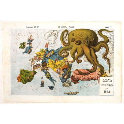
La Piovra Russa. Carta Serio-Comica Pel 1878.
Very rare political caricature map by Grossi of the nations of Europe, published in Bologna in the supplement of the newspaper "Le Perroquet / Al papagallo, N° 15, Anno VI.Known as the Octopus Map ; the brooding presence of the Russian Empire depicted as a massive octopus, whose tentacles stretch out towards Europe. In this map, the Octopus has Turkey, Persia and Poland but has been wounded by Crimea and is being fought off by Germany.This map, by Grossi, followed the style created by Frederick...
€1.850
Maker : GROSSI, A.
Place : Bologne
Date : 14 avril 1878
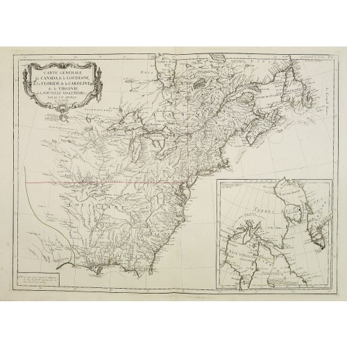
Carte Générale du Canada, de la Louisiane, de la Floride, de la Caroline..
Map of the eastern part of the United States and Canada. With inset map of Hudson and Baffin bays. in the lower right corner.Venetian edition of d'Anville's map, from "Atlas Universel" printed in 1776-84.Noteworthy topographical detail is shown, with particular focus on the Great Lakes. Lake Superior is shown attached to a convoluted river system reaching across the continent reminiscent of the Riviere Longue of Baron Lahontan's memoirs.On the Gulf Coast the region of Tecas (Texas) is named with...
€750
Maker : SANTINI, P. / REMONDINI, M.
Place : Venice
Date : 1784
Postage & Shipping
-
Item Location
Terms and conditions - Item Location
- 75013, Ile-de-France, France
- Ships To
- United States, United Kingdom, Albania, Argentina, Armenia, Australia, Austria, Bahamas, Belgium, Bermuda, Bosnia and Herzegowina, Brazil, Bulgaria, Canada, Chile, China, Costa Rica, Denmark, Dominica, Egypt, El Salvador, Finland, France, Germany, Greece, Guatemala, Hong Kong, Hungary, Iceland, India, Italy, Japan, Korea (South), Kuwait, Liechtenstein, Lithuania, Luxembourg, Madagascar, Mexico, Monaco, Morocco, Netherlands, Netherlands Antilles, New Zealand, Norway, Paraguay, Peru, Philippines, Poland, Portugal, Qatar, Reunion, Romania, San Marino, Saudi Arabia, Seychelles, Singapore, Slovenia, South Africa, Spain, Sri Lanka, Suriname, Sweden, Switzerland, Taiwan, Thailand, Tunisia, Turkey, United Arab Emirates, Uruguay, Vietnam
- Pick-ups
- Buyer can pick-up
This item is owned and offered by the seller Librairie_Loeb-Larocque - All items are available for immediate sale, offered subject to prior sale.
Invoices are created by the seller by using our shopping cart or be prepared by the seller the day following the order and are emailed to you.
Items offeres by different sellers are invoiced separately.
Shipping fees are extra. The buyer is responsible for all applicable taxes, including any VAT, customs clearance, import duties, or equivalent costs arriving at the customer's home border. Payment is due on receipt of the invoice. The item(s) are shipped as soon as possible after receipt of your payment.
Before buying please read the complete Terms Conditions of Sale.
- Payment Methods
- Visa, Mastercard, Bank Transfer, American Express, iDEAL, PayPal, Google Pay
- Returns Accepted
- No
Post Message
Feel free to ask the seller a question. Please note that the seller could be located in an area with a different time zone. Our seller will do their best to respond within 24 hours.Post your message below.
Sign in to ask the seller a question.
![[Les anciennes provinces Françaises à la ville de Saint Denis].](/uploads/cache/41683-500x500.jpg)
![[Les anciennes provinces Françaises à la ville de Saint Denis].](/uploads/cache/41681-500x500.jpg)

![[How natives of Paria cope with illness] / Vespucci reaches Lake Maracaibo]..](/uploads/cache/41095-(2)-500x500.jpg)