ID: 446
Open
Listing ID: #231 has been added to your wishlist.
Listing ID: #161 has been added to your wishlist.
![[Les anciennes provinces Françaises à la ville de Saint Denis].](/uploads/41683.jpg)
[Les anciennes provinces Françaises à la ville de Saint Denis].
BuyNow for €80
- Maker :
- H. LAAS & PECAUD & CIE PARIS
- Place :
- Paris
- Date :
- circa 1900
- Color :
- Printed colors
- Height mm.:
- 405
- Width mm.:
- 304
- Condition :
- Nine small chromolithography pasted on one sheet. Each trade card is 113mm x 81mm in very good condition.
- Bibliography :
- -
- Seller's ref. :
- 41683
This item is offered by Librairie_Loeb-Larocque
See other Items from this seller- Postage
-
France
€15 to France
- Select Country
- Zip/Post Code
- Quantity
€80
Description
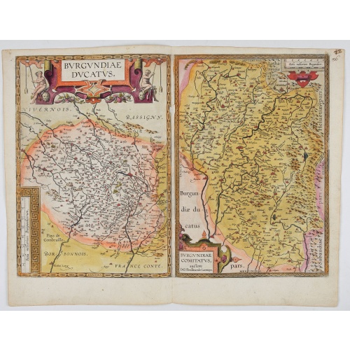
Nine small chromolithography trade cards for Ville de Saint-Denis, each with French regions and places, with description in French on each verso.Cards of the regions: Lorraine, Bourgogne, Flandre, Lyonnais, Alsace, Champagne, Artois, Orléanais, Dauphiné.
France.
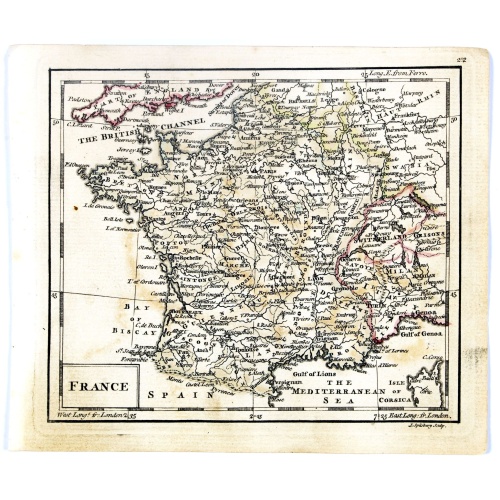
Uncommon miniature map of France, engraved by J.Spilbury for "A New General and Universal Atlas Containing Forty five Maps by Andrew Dury".This miniature atlas published during the Seven Years' War.The maps are typical for the period and well executed with great clarity. The plates are engraved in 1761 and in 1763 a second edition was presumably produced for the French market having all but nine with a French titles added above the top.
€50
Maker : DURY, A. / SAYER, R. / KITCHIN, T.
Place : London
Date : 1761-1763
-500x500.jpg)
INTERIEUR DE L'EGLISE SAINT OUEN A ROUEN. Dessiné d'après nature par Chapuy. Lith. Par Arnout. Fig par Bayot.
Original lithograph of the inside of Saint Ouen chruch, situated in Rouen. Lithographed by Arnout and Adolphe-Jean-Baptist Bayot (Alessandria 1810 - 1866) after a design by Chapuy and printed in Paris by Lemercier, Bernard Cie.
€50
Maker : CHAPUY
Place : Paris
Date : 1844
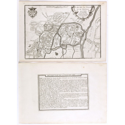
Plan de la ville et du château de Caën en Normandie.
Plan of the city of Caen, from Nicolas de Fer's "L'Atlas curieux ou le Monde réprésente dans des cartes. "The "Atlas Curieux" is a geographic encyclopedia of images and a celebration of the French Empire under the Sun King, with maps of French possessions in the western hemisphere, maps of France, with detailed views of the grand waterworks at Marly, views of the great palaces and chateaux, views and plans of the Paris Observatory, and samples of military architecture. Issued in six annual par...
€60
Maker : DE FER, N.
Place : Paris, 1705
Date : 1705
![[Another Dutch fleet reaches Lima].](/uploads/cache/41117-500x500.jpg)
[Another Dutch fleet reaches Lima].
In 1624 a heavily armed Dutch fleet sailed from the Juan Fernandez Islands to Lima. The leader of the fleet, Jacob l’Hermite, was in such poor health that he had to hand over command to Admiral Jacobson. The fleet anchored outside the harbour near the island of San Lorenzo (‘I. de Lima’). The port was full of Spanish ships and was too well protected for a direct confrontation so, on the night of 11th May, the Dutch carried out a daring and devious plan. In 1631 Johann Ludwig Gottfried, inh...
€80
Maker : GOTTFRIED, J.L. / DE BRY.
Place : Frankfurt, M.Merian
Date : 1633
Postage & Shipping
-
Item Location
Terms and conditions - Item Location
- 75013, Ile-de-France, France
- Ships To
- United States, United Kingdom, Albania, Argentina, Armenia, Australia, Austria, Bahamas, Belgium, Bermuda, Bosnia and Herzegowina, Brazil, Bulgaria, Canada, Chile, China, Costa Rica, Denmark, Dominica, Egypt, El Salvador, Finland, France, Germany, Greece, Guatemala, Hong Kong, Hungary, Iceland, India, Italy, Japan, Korea (South), Kuwait, Liechtenstein, Lithuania, Luxembourg, Madagascar, Mexico, Monaco, Morocco, Netherlands, Netherlands Antilles, New Zealand, Norway, Paraguay, Peru, Philippines, Poland, Portugal, Qatar, Reunion, Romania, San Marino, Saudi Arabia, Seychelles, Singapore, Slovenia, South Africa, Spain, Sri Lanka, Suriname, Sweden, Switzerland, Taiwan, Thailand, Tunisia, Turkey, United Arab Emirates, Uruguay, Vietnam
- Pick-ups
- Buyer can pick-up
This item is owned and offered by the seller Librairie_Loeb-Larocque - All items are available for immediate sale, offered subject to prior sale.
Invoices are created by the seller by using our shopping cart or be prepared by the seller the day following the order and are emailed to you.
Items offeres by different sellers are invoiced separately.
Shipping fees are extra. The buyer is responsible for all applicable taxes, including any VAT, customs clearance, import duties, or equivalent costs arriving at the customer's home border. Payment is due on receipt of the invoice. The item(s) are shipped as soon as possible after receipt of your payment.
Before buying please read the complete Terms Conditions of Sale.
- Payment Methods
- Visa, Mastercard, Bank Transfer, American Express, iDEAL, PayPal, Google Pay
- Returns Accepted
- No
Post Message
Feel free to ask the seller a question. Please note that the seller could be located in an area with a different time zone. Our seller will do their best to respond within 24 hours.Post your message below.
Sign in to ask the seller a question.
![[Les anciennes provinces Françaises à la ville de Saint Denis].](/uploads/cache/41683-500x500.jpg)