ID: 468
Open
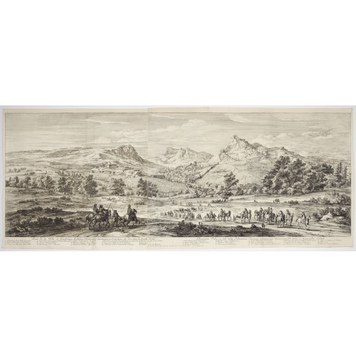
Veue de la ville, et fauxbourg de Salins…
BuyNow for €700
- Maker :
- MEULEN, Adam Frans van der.
- Place :
- Paris
- Date :
- 1680
- Color :
- Uncoloured
- Height mm.:
- 470
- Width mm.:
- 1315
- Condition :
- Two sheets joined. Size of the plate with key : 535 x 1335 mm. Many vertical folds expertly reinforced and repaired. Upper margin cut to neatline with reinstalled margin. Good and dark impression.
- Bibliography :
- -
- Seller's ref. :
- 47332
This item is offered by Librairie_Loeb-Larocque
See other Items from this seller- Postage
-
France
€15 to France
- Select Country
- Zip/Post Code
- Quantity
€700
Description
Showing the town of Salins, a commune with salt works (Salines) in the Jura department in the region of Bourgogne-Franche-Comté in eastern France. With a key (1-15) in Latin and French to the most remarkable sights. Etching by A. F. Bauduins (Adrien François Baudouin) after Adam Frans van der Meulen (1632-1690) who was a Flemish Baroque painter specialising in battle scenes. He was active first in Brussels, where he was a pupil of Pieter Snayers, and from the 1660s onwards in Paris.
His paintings during the campaigns of Flanders in 1667 so delighted Louis that from that date van der Meulen was ordered to accompany him in all his expeditions. In 1673 he was received into the Académie royale de peinture et de sculpture, attained the grade of councillor in 1681, and died full of honors in Paris in 1690.
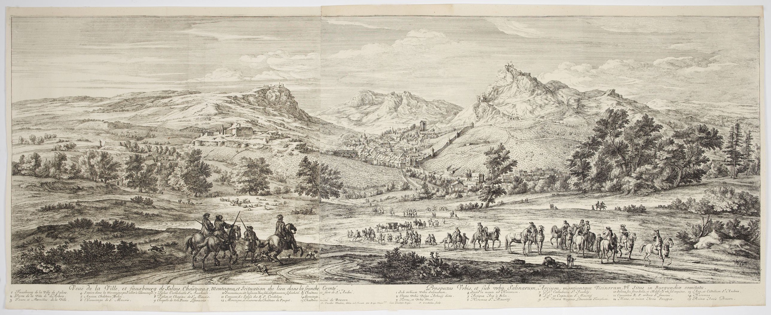
Amérique Méridionale.
Nice small map of South America. Dated 1748. From Atlas Portatif Universel, by Robert de Vaugondy.Page 105 outside border top right. Mary Sponberg Pedley does not mention a state without date.
€75
Maker : VAUGONDY, R. de
Place : Paris
Date : later than 1748
![[How natives of Paria cope with illness] / Vespucci reaches Lake Maracaibo]..](/uploads/cache/41095-500x500.jpg)
[How natives of Paria cope with illness] / Vespucci reaches Lake Maracaibo]..
Two engravings. [421b] When the natives of those parts, they were bathed in a cold stream, then chased round a blazing fire until they had dried out. Then they were put to bed and great care was taken to ensure their loins were dry. Vomiting was overcome by fasting for three or four days and paying careful attention to diet., which rarely included meat, except for human flesh, of which they were inordinately fond. In fact they would even fatten their enemy captives before eating them and seemed ...
€80
Maker : GOTTFRIED, J.L. / DE BRY.
Place : Frankfurt, M.Merian
Date : 1633
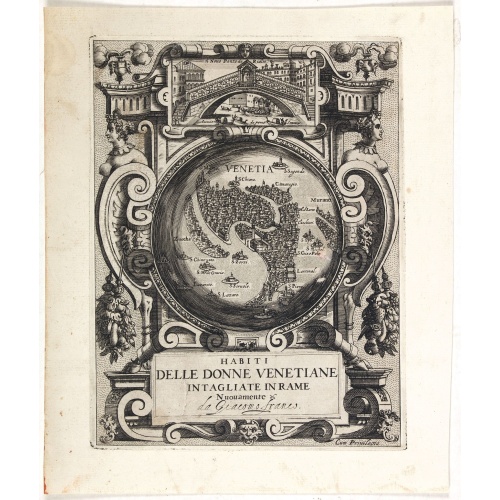
Habiti delle Donne Venetiane . . .
Title page of the book Habiti delle Donne Venetiane" (Dress of Venetian Women) which consists of twenty numbered plates of ornately dressed women. This very decorative title page shows in to Rialto Bridge and in the center a bird's-eye plan of Venice.Giacomo Franco (1556-1620) was born and grew in Venice, where he used to work. He was the son of painter Giovanni-Battista Franco (1510-1561), with whom he began his artistic training at the age of eleven. He worked as a painter, engraver, woodcutte...
€950
Maker : FRANCO, G.
Place : Venice
Date : ca. 1591
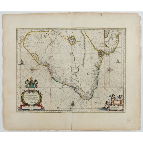
Brasilia.
Fine copy of this map by Krystof Arciszewski, a Polish general who worked for the Dutch West Indian Company. The map perpetuates various myths including the Parime Lago , although it is generally more accurate than its predecessors. Orientated with west to the top. Including the mouth of the Amazon.
€700
Maker : BLAEU, J.
Place : Amsterdam
Date : 1647
Postage & Shipping
-
Item Location
Terms and conditions - Item Location
- 75013, Ile-de-France, France
- Ships To
- United States, United Kingdom, Albania, Argentina, Armenia, Australia, Austria, Bahamas, Belgium, Bermuda, Bosnia and Herzegowina, Brazil, Bulgaria, Canada, Chile, China, Costa Rica, Denmark, Dominica, Egypt, El Salvador, Finland, France, Germany, Greece, Guatemala, Hong Kong, Hungary, Iceland, India, Italy, Japan, Korea (South), Kuwait, Liechtenstein, Lithuania, Luxembourg, Madagascar, Mexico, Monaco, Morocco, Netherlands, Netherlands Antilles, New Zealand, Norway, Paraguay, Peru, Philippines, Poland, Portugal, Qatar, Reunion, Romania, San Marino, Saudi Arabia, Seychelles, Singapore, Slovenia, South Africa, Spain, Sri Lanka, Suriname, Sweden, Switzerland, Taiwan, Thailand, Tunisia, Turkey, United Arab Emirates, Uruguay, Vietnam
- Pick-ups
- Buyer can pick-up
This item is owned and offered by the seller Librairie_Loeb-Larocque - All items are available for immediate sale, offered subject to prior sale.
Invoices are created by the seller by using our shopping cart or be prepared by the seller the day following the order and are emailed to you.
Items offeres by different sellers are invoiced separately.
Shipping fees are extra. The buyer is responsible for all applicable taxes, including any VAT, customs clearance, import duties, or equivalent costs arriving at the customer's home border. Payment is due on receipt of the invoice. The item(s) are shipped as soon as possible after receipt of your payment.
Before buying please read the complete Terms Conditions of Sale.
- Payment Methods
- Visa, Mastercard, Bank Transfer, American Express, iDEAL, PayPal, Google Pay
- Returns Accepted
- No
Post Message
Feel free to ask the seller a question. Please note that the seller could be located in an area with a different time zone. Our seller will do their best to respond within 24 hours.Post your message below.
Sign in to ask the seller a question.