
ID: 147
Closed
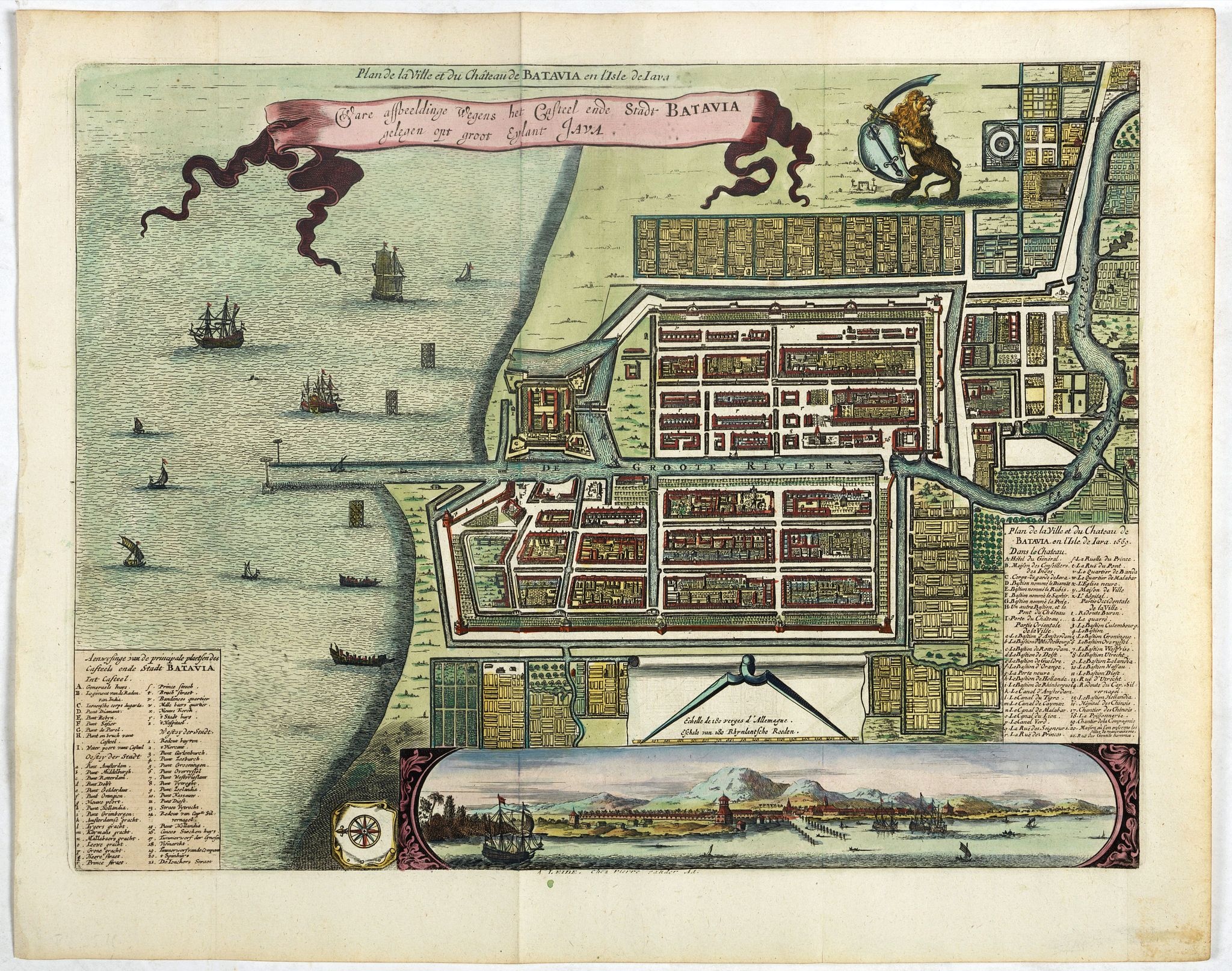
Ware affbeeldinge wegens het casteel ende stadt Batavia. . .
BuyNow for $800
- Maker :
- VANDER AA, P.
- Place :
- Leiden
- Date :
- 1719
- Color :
- Colored
- Height mm.:
- 265
- Width mm.:
- 355
- Condition :
- In good condition. Very dark impression. Paper very slightly age toned.
- Bibliography :
- -
- Seller's ref. :
- 38349
This item is offered by Paulus_Swaen_Old_Maps
See other Items from this seller- Postage
-
Europe
$34 to France
- Select Country
- Zip/Post Code
- Quantity
$800
Description
A reduced version of Clement de Jonghe (1650) plan of Jakarta from 1650. The town plan has a vignette at the bottom showing Jakarta from the sea with the volcanoes Mount Gede, Mount Pangrnago and Mount Salak in the background.Engraved for Arnoldus Montanus "Gedenkwaerdige gesantschappen der Oost-Indische maatschappy in ’t Vereenigde Nederland. . ." (1669) but reissued by Pieter van der AA.
Batavia, present-day Jakarta, the Dutch center of trading activities in the East Indies. European and native ships are shown in the sea, while the Dutch lion stands proudly above the schematically planned city.

Universe Europae Maritime Eiusque Navigationis Descriptio. Generale Pascaerte van Europa . . .
This general chart of north-western Europe and the surrounding coastal waters is from the rare pilot-guide De Spiegel der Zeevaerdt , printed by Christopher Plantin in Leyden.FIRST PLATE AND FIRST STATE, which appeared in the first 3 editions, before Latin names of some seas and inscriptions in the scale bars were added. (editions 4-12). EXTREMELY RARE.The map's title is given in both Latin and Dutch, with the latter attributing it to Waghenaer and nothing a privilege of ten years. The date 1583...
$25.000
Maker : WAGHENAER, L.J.
Place : Leyden
Date : 1584

Freedom of the Air.
A world map packed with information about aviation and the aluminum industry.The use of aircraft in warfare, especially in the roles of close ground support and strategic bombing, was completely revolutionized during WWII. Apart from tactics, the technology also evolved to facilitate heavier bombers, faster fighters, more capable transports and greater range all-around. One critical component of this development was using light, flexible and sturdy aluminum frames and skins for the planes, rathe...
$230
Maker : ALCOA ALUMINUM COMPANY.
Place : United-States
Date : 1943

Rotterdam
A bird's-eye view of the town. With extensive shipping in the foreground. From "Topographia Germaniae Inferioris". Matthäus Merian, the leading German illustrator of the 17th century, was born in Basel in 1593. He learned the art of copperplate engraving in Zurich and subsequently worked and studied in Strasbourg, Nancy, Paris, and the Low Countries. In 1618 he went to Frankfurt, wherein 1618 he marries the eldest daughter of J.T. de Bry, publisher and engraver. After de Bry died in 1623, he ...
$1.750
Maker : MERIAN, C.
Place : Frankfurt
Date : 1659

Lyste vande prysen der goederen ingekoft by de Kamer. . .
Rare price list of meat, bacon, wheat, rye, butter, cheese, olive oil, Spanish wines, Bordeaux, brandy etc.On front page in letter press Lyste Van de Pryfen der Goederen, Ingekofst by de Kamer van de OOST-INDISCHE COMPAGNIE tot Gestelt na de datums van der zelver inkoop.Dated in manuscript 1685. Rare pricelist of articles purchased by the V.O.C. over the year 1685. Including large quantities of French wines!. Very rare.
$2.500
Maker : V.O.C.
Place : Amsterdam
Date : 1685
Postage & Shipping
-
Item Location
Terms and conditions - Item Location
- Amsterdam, , Netherlands
- Ships To
- United States, United Kingdom, Albania, Argentina, Armenia, Australia, Azerbaijan, Bahamas, Belgium, Bermuda, Cambodia, Canada, Chile, China, Croatia, Cyprus, Czech Republic, Denmark, Estonia, Finland, France, Germany, Gibraltar, Greece, Greenland, Guatemala, Hong Kong, Iceland, India, Indonesia, Israel, Italy, Japan, Latvia, Lithuania, Luxembourg, Malta, Mexico, Monaco, Netherlands, Norway, Singapore, Spain, Sweden, Switzerland, Turkey
- Pick-ups
- No pick-ups
This item is owned and offered by the seller Paulus_Swaen_Old_Maps - All items are available for immediate sale, offered subject to prior sale.
Invoices are created by the seller by using our shopping cart or be prepared by the seller the day following the order and are emailed to you.
Items offeres by different sellers are invoiced separately.
Shipping fees are extra. The buyer is responsible for all applicable taxes, including any VAT, customs clearance, import duties, or equivalent costs arriving at the customer's home border. Payment is due on receipt of the invoice. The item(s) are shipped as soon as possible after receipt of your payment.
Before buying please read the complete Terms Conditions of Sale.
- Payment Methods
- Visa, Mastercard, Bank Transfer, American Express, iDEAL, PayPal
- Returns Accepted
- No
Post Message
Feel free to ask the seller a question. Please note that the seller could be located in an area with a different time zone. Our seller will do their best to respond within 24 hours.Post your message below.
Sign in to ask the seller a question.
