
ID: 147
Closed
Listing ID: #147 has been added to your wishlist.
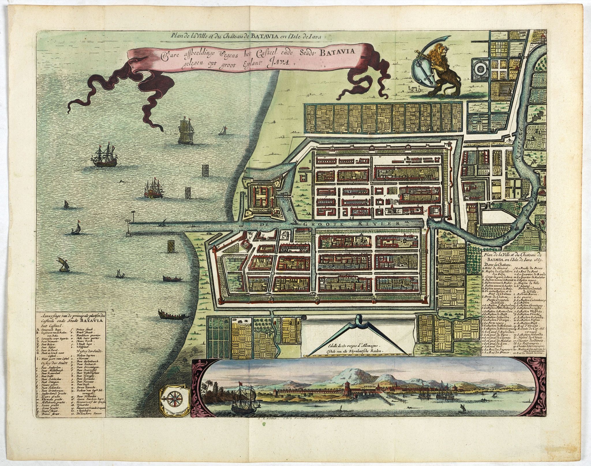
Ware affbeeldinge wegens het casteel ende stadt Batavia. . .
BuyNow for $800
- Maker :
- VANDER AA, P.
- Place :
- Leiden
- Date :
- 1719
- Color :
- Colored
- Height mm.:
- 265
- Width mm.:
- 355
- Condition :
- In good condition. Very dark impression. Paper very slightly age toned.
- Bibliography :
- -
- Seller's ref. :
- 38349
This item is offered by Paulus_Swaen_Old_Maps
See other Items from this seller- Postage
-
Europe
$34 to France
- Select Country
- Zip/Post Code
- Quantity
$800
Description
A reduced version of Clement de Jonghe (1650) plan of Jakarta from 1650. The town plan has a vignette at the bottom showing Jakarta from the sea with the volcanoes Mount Gede, Mount Pangrnago and Mount Salak in the background.Engraved for Arnoldus Montanus "Gedenkwaerdige gesantschappen der Oost-Indische maatschappy in ’t Vereenigde Nederland. . ." (1669) but reissued by Pieter van der AA.
Batavia, present-day Jakarta, the Dutch center of trading activities in the East Indies. European and native ships are shown in the sea, while the Dutch lion stands proudly above the schematically planned city.

Vertoog van het regt, Dat de Vereenigde Nederlandsche Oost-Indische maatschappye Heeft op de Vaart en Koophandel naar Oost-Indiën, Tegen de inwooners van de Spaanse, nu de Oostenrykse Nederlanden.
Dutch translation of the Latin edition, published in 1723. Westerveen was the secretary of the Dutch East India Company and writes on the right of the VOC to trade as well as on VOC maritime trade with the East Indies. Westerveen also addresses these matters with regard to the Dutch West India Company and deals with Dutch trade in the light of the interests of both Spain and Portugal in the Americas and in Asia.Also contains an interesting Extract uyt de Resolutien door den Gouverneur Generaal e...
$1.200
Maker : WESTERVEEN, A.
Place : Amsterdam
Date : 1724

Inventio Maris Magallanici.
Allegorical scene allegorical image celebrating the circumnavigation of the earth by Ferdinand Magellan. The image shows Magellan on board of his ship, surrounded by mythological figures including Apollo with sun and lyre, Zeus on his throne of clouds, Adam and Eve. A bird carrying an elephant and a depiction of the Tierra del Fuego.The image also includes cannon, banner with the double-headed Hapsburg eagle, anchor, broken mast, navigational instruments such as armillary sphere and dividers, se...
$750
Maker : DE BRY, Th.
Place : Frankfurt
Date : 1594

Gelriae, Cliviae, Finitimorumque Locorum Verissima..
East to the top. Fine map of Geldria and Limburg, prepared by Christian s'Grooten. Very fine title cartouche lower right with painter's utensils around the cartouche.Dare to go in Black. All early maps were printed in black and white, and many were kept that way for a long time. A black and white map in an early and strong impression is a rarity nowadays, being so many examples recently colored up!
$250
Maker : ORTELIUS, A.
Place : Antwerp
Date : 1598
Marine parallel rulers in brass.
Very fine marine parallel rulers in brass. The parallel ruler is the oldest and most traditional way to measure and trace routes and bearings. The principle is simple: the ruler is placed on the road to be measured and then, like a pantograph, the other part of the ruler is placed on one of the declination roses on the map to determine the angle. They are, essentially, two straight-edges hinged so that they maintain the same angle. By alternating the moving edge, and securely holding down the no...
$1.500
Maker : ANONYMOUS
Place : Paris
Date : ca. 1880
Postage & Shipping
-
Item Location
Terms and conditions - Item Location
- Amsterdam, , Netherlands
- Ships To
- United States, United Kingdom, Albania, Argentina, Armenia, Australia, Azerbaijan, Bahamas, Belgium, Bermuda, Cambodia, Canada, Chile, China, Croatia, Cyprus, Czech Republic, Denmark, Estonia, Finland, France, Germany, Gibraltar, Greece, Greenland, Guatemala, Hong Kong, Iceland, India, Indonesia, Israel, Italy, Japan, Latvia, Lithuania, Luxembourg, Malta, Mexico, Monaco, Netherlands, Norway, Singapore, Spain, Sweden, Switzerland, Turkey
- Pick-ups
- No pick-ups
This item is owned and offered by the seller Paulus_Swaen_Old_Maps - All items are available for immediate sale, offered subject to prior sale.
Invoices are created by the seller by using our shopping cart or be prepared by the seller the day following the order and are emailed to you.
Items offeres by different sellers are invoiced separately.
Shipping fees are extra. The buyer is responsible for all applicable taxes, including any VAT, customs clearance, import duties, or equivalent costs arriving at the customer's home border. Payment is due on receipt of the invoice. The item(s) are shipped as soon as possible after receipt of your payment.
Before buying please read the complete Terms Conditions of Sale.
- Payment Methods
- Visa, Mastercard, Bank Transfer, American Express, iDEAL, PayPal
- Returns Accepted
- No
Post Message
Feel free to ask the seller a question. Please note that the seller could be located in an area with a different time zone. Our seller will do their best to respond within 24 hours.Post your message below.
Sign in to ask the seller a question.