
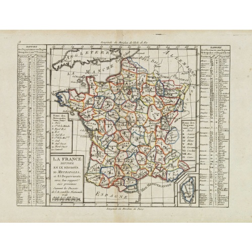
La France Divisée en IX Régions, 10 Métropoles, et 85 Départements ..
Scarce map of France prepared after J.B.Nolin and published by Mondhare for his Atlas Général a l'usage des colleges et maisons d'education.. Lower right inset map of Corsica. In left and right margins key references to Départements and Provinces. Louis Joseph Mondhare was active in Paris and published several smaller atlases and re-published the wall maps of Nolin.
€60
Maker : MONDHARE, L.J. / NOLIN, J.B.
Place : Paris
Date : 1783
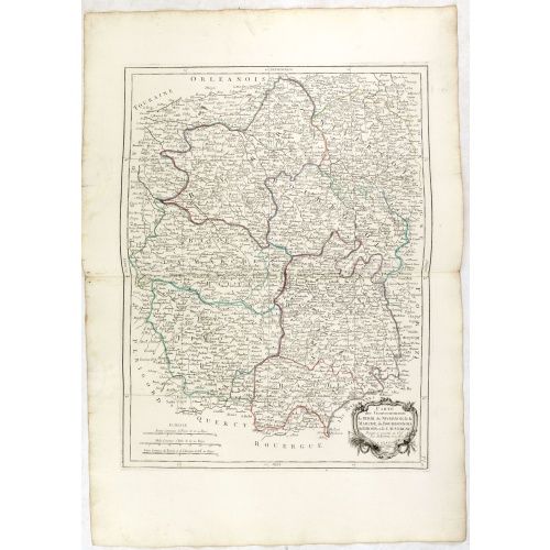
Gouvernements de Berri, du Nivernois,de la Marche, Limousin..
Detailed map encompassing Berri, Nivernois, Limousin and Auvergne.Venetian edition of the map by Bonne, to whom Santini gives credit in the cartouche.From "Atlas Universel" published by Santini in 1776-84. The atlas is effectively an Italian copy of the Robert de Vaugondy 'Atlas Universel'.In 1784 Santini sold the plates to M. Remondini, whose name appears on this particular example.
€75
Maker : SANTINI,P. / REMONDINI,M.
Place : Venice
Date : 1776 - 1784
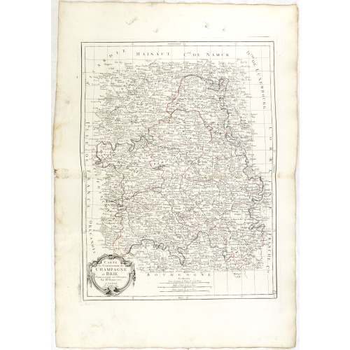
Gouvernements de Champagne et Brie.
Detailed map encompassing Champagne and Brie.Venetian edition of the map by Bonne, to whom Santini gives credit in the cartouche.From "Atlas Universel" published by Santini in 1776-84. The atlas is effectively an Italian copy of the Robert de Vaugondy 'Atlas Universel'.In 1784 Santini sold the plates to M. Remondini, whose name appears on this particular example.
€75
Maker : SANTINI, P. / REMONDINI, M.
Place : Venice
Date : 1776 - 1784
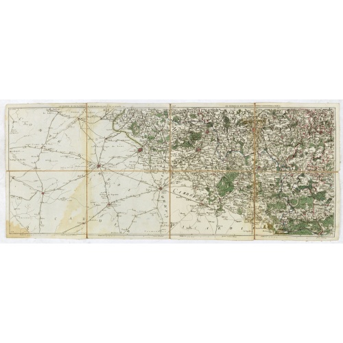
Les environs de Mons, Beaumont, Chimay, Valenciennes, Condé, &c.
Detailed map of Northern France, centered on Valenciennes and Mons. The map was prepared by Jean Baptiste de Bouge (1757-1833), who prepared one of the first very detailed maps of Belgium.Map 9 of a large wall map of Belgium.
€50
Maker : DE BOUGE, J-B.
Place : Bruxelles
Date : 1789 - 1793
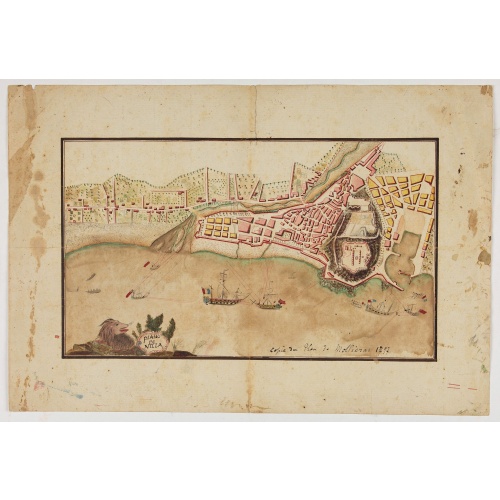
Piano di Nizza.
Rare 1797 manuscript map of Nice, with the French navy attacking from the sea. Unknown author, Italian, but map attributed to an original, probably broadsheet map by Mollieras (?). Good plan of the layout of Nice and the port and coast as was in 1797. Ships are perhaps a trifle naive. This attack is not covered by any other antique maps or prints.The sheet is watermarked with the initials JH & Z, for Jan Honig and Zoonen, a firm of papermakers operating in Zaandijk, north of Amsterdam operating ...
€900
Maker : ANONYMOUS
Place : Italy
Date : after 1797
Carte du royaume de France divisé en 87 départemens / dressée par Brion de la Tour..., où sont tracées les nouvelles limites fixées par le traité de paix du 30 mai 1814. . .
Very decorative and uncommon map of France, with Corsica prepared by Brion de la Tour showing the new border set by the Peace Treaty of May 30, 1814. Engraved by Chaumier. The map is bordered by French Kings up to Louis XVIII.The Treaty of Paris was made between representatives of the allies and France following the restoration of Louis XVIII. The terms towards France were relatively lenient to assist the Bourbon restoration, although provisions were made for a strengthening of the states border...
€750
Maker : DESNOS/ BRION DE LA TOUR.
Place : Paris
Date : ca. 1814
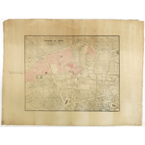
Quartier de Tivoli Nouveaux pereements de Rues.
Plan of the center of Paris showing Tivoli district with Madalene and Clichy. Lithography and pen and ink. Drawn in are the planned workshop of Serrurerie Théophile Mignon, 30 rue de la Bienfaisance.
€75
Maker : ANNONYMOUS
Place : Paris
Date : ca.1835

INTERIEUR DE LA CATHEDRALE A CHARTRES. Dessiné d'après nature par Chapuy. Lith. Par Bachelier.
Original lithograph of the inside of the cathedral situated in Chartres. Lithographed by Bachelier after a design by Chapuy and printed in Paris by Lemercier, Bernard Cie.
€50
Maker : CHAPUY
Place : Paris
Date : 1844
-500x500.jpg)
TOMBEAU DU DUC DE BREZE, DANS LA CATHEDRALE DE ROUEN. Dessiné d'après nature par Chapuy. Lith. par Monthelier. Fig. par Bayot.
Original lithography of the tomb of the duke of Brézé, in the cathedral of Rouen. Lithographed by Jules Monthelier (1801-1883) and Adolphe-Jean-Baptist Bayot (Alessandria 1810 - 1866) after a design by Chapuy and printed in Paris by Lemercier, Bernard Cie.
€50
Maker : CHAPUY
Place : Paris
Date : 1844

PORTAIL SEPTENTRIONAL DE LA CATHÉDRALE A CHARTRES. Dessiné d'après nature par Monthelier. Lith. par Monthelier.fig. par Bayot.
Original lithograph of the northern portal of Chartres cathedral. Lithographed by Jules Monthelier (1801-1883) and Adolphe-Jean-Baptist Bayot (Alessandria 1810 - 1866) after a design by Chapuy and printed in Paris by Lemercier, Bernard Cie.
€75
Maker : CHAPUY
Place : Paris
Date : 1844
-500x500.jpg)
ÉGLISE St. VINCENT A ROUEN. Dessiné d'après nature par Chapuy. Lith. par Monthelier. Fig. par Bayot.
Original lithograph of St Vincent cathedral, situated in Rouen. Lithographed by Jules Monthelier (1801-1883) and Adolphe-Jean-Baptist Bayot (Alessandria 1810 - 1866) after a design by Chapuy and printed in Paris by Lemercier, Bernard Cie.
€80
Maker : CHAPUY
Place : Paris
Date : 1844
-500x500.jpg)
INTERIEUR DE L'EGLISE SAINT OUEN A ROUEN. Dessiné d'après nature par Chapuy. Lith. Par Arnout. Fig par Bayot.
Original lithograph of the inside of Saint Ouen chruch, situated in Rouen. Lithographed by Arnout and Adolphe-Jean-Baptist Bayot (Alessandria 1810 - 1866) after a design by Chapuy and printed in Paris by Lemercier, Bernard Cie.
€50
Maker : CHAPUY
Place : Paris
Date : 1844
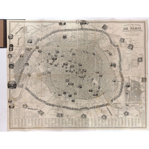
Nouveau plan illustré de la ville de Paris . . .
Fine plan of Paris, engraved by Taylor. "With the complete system of its fortifications and strong detached". Adorned with many vignettes engraved with monuments of Paris.
€900
Maker : VUILLEMIN, A.
Place : Paris
Date : 1847
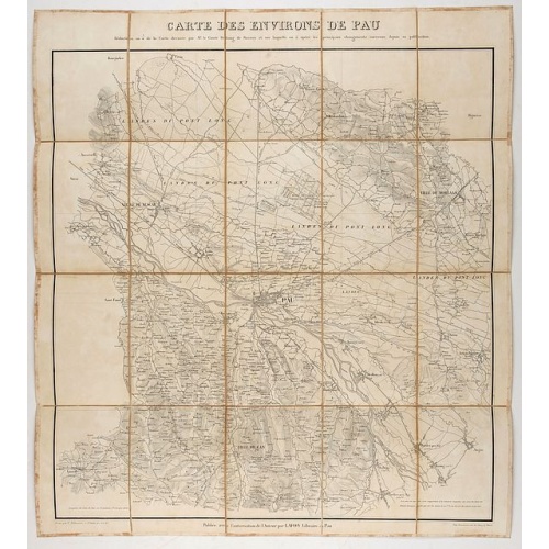
Carte des environs de Pau. . .
Folding map of Pau and its surroundings, being a reduced version of the map by Comte Dulong de Rosnay and engraved by Nicolas Delamare and published by Lafon.
€75
Maker : VCOMTE DULONG DE ROSNAY
Place : Pau, Lafon
Date : 1840-1850
-500x500.jpg)
Dépt. De La Haute Loire. N°42.
Map of the Upper Loire region in France.Lovely map from one of the last decorative atlases of the nineteenth century.The rather simple map is framed by medallion portraits and coats of arms, and is set against a background of scenes of the countryside, products and activities indigenous to the region filling the foreground.Victor Levasseur's "Atlas National Illustre" and "Atlas Universel Illustre" are among the last great decorative atlases published. This map comes from the Atlas National Illus...
€50
Maker : LEVASSEUR, V.
Place : Paris
Date : A. Combette, 1852
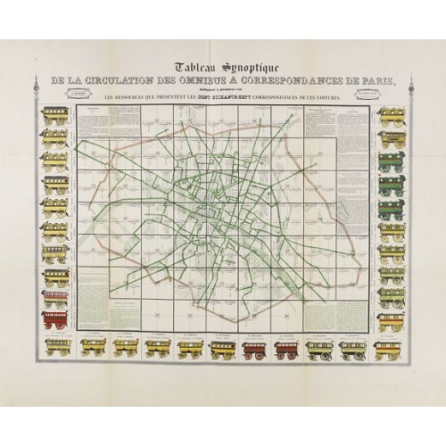
Tableau synoptique de la circulation des omnibus à correspondances de Paris.
Synoptic table of the circulation of omnibuses with connections of Paris indicating at first sight the resources presented by the one hundred and sixty-seven connections of these cars. Rare map of Paris divided into Grands Carrés showing omnibus stations and connections. The lines in green indicate the route of the bus lines. It is surrounded by 31 vignettes showing the different omnibuses: Omnibus, Constantines, Favorites, Tricycles, Diligentes, Citadines, Hirondelles, Parisiennes, Gazelles, ...
€750
Maker : RICHARD, V.
Place : Paris
Date : ca. 1854
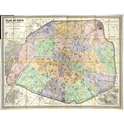
Plan de Paris A l'Echelle de 2 Millim. pour 2.5 Metres . . . Indiquant les Nouveaux percements et les changements de mons de Voies publiques Avec Plans Supplmentaries Pour Les Bois De Boulogne et De Vicennes . . .
Magnificent map of the urban redevelopments planned for Paris at the end of the 19th century. The map has been updated, with insets showing supplemental plans for the Bois de Boulogne and Vicennes neighborhoods.
€600
Maker : ANDRIVEAU-GOUJON, E.
Place : Paris
Date : 1878
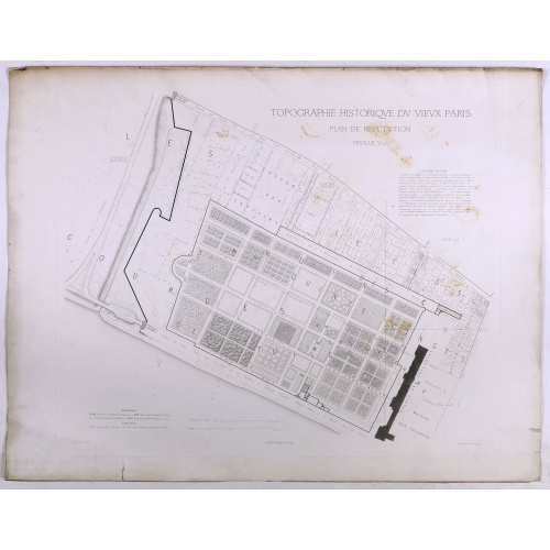
Topographie historique du vieux Paris / Plan de restitution Feuille V bis.
Copper engraved plan centered on gardens of the Louvre by Jean-Joseph Sulpis (1826–1911) after a model by Adolphe Berty. Plate 5bis from "Topographie historique du vieux Paris". The publication was started by Adolphe Berty and continued by H. Legrand and L.-M. Tisserand, Th. Vacquer and Camille Platon.
€50
Maker : BERTY, A.
Place : Paris
Date : 1866-1897
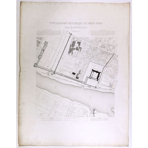
Topographie historique du vieux Paris / Plan de restitution Feuille V.
Copper engraved plan centered on Louvre by Jean-Joseph Sulpis (1826–1911) after a model by Adolphe Berty. Plate 5 from "Topographie historique du vieux Paris". The publication was started by Adolphe Berty and continued by H. Legrand and L.-M. Tisserand, Th. Vacquer and Camille Platon.
€75
Maker : BERTY, A.
Place : Paris
Date : 1866-1897
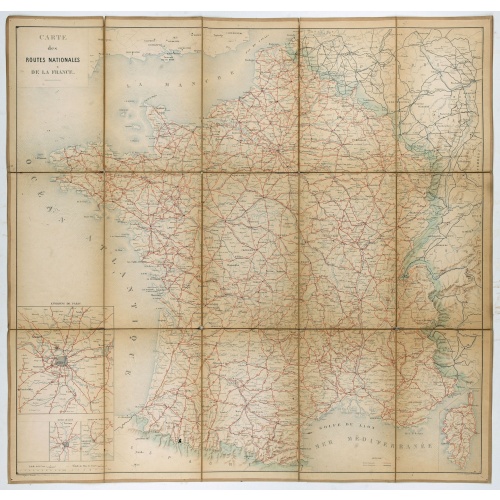
Carte nationale des routes de la France.
Map of the national roads in France, engraved and published by Regnier et Dourdet. Four inset maps of which three shows the three largest cities in France and one shows Corsica.
€75
Maker : REGNIER ET DOURDET
Place : Paris
Date : ca. 1900