
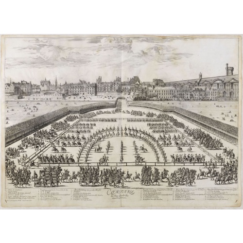
Comparse des Cinq Quadrilles dans l'Amphitheatre.
An early and intriguing engraving recording one of the most celebrated and spectacular festivals held at Paris by the young Louis XIV. The multi-day tournament took place in front of the Tuileries, in a huge area today known as the Place de Carrousel. Groups of costumed noblemen representing "Romans" (lead by the French King), "Persians," "Turks," "Indians" and "Americans" participated in games of skill. This engraving was included as an illustration to a scarce work titled, "Courses de Testes e...
€550
Maker : SYLVESTRE, I.
Place : Paris, Imprimerie royale
Date : 1670
![In einem Todt. . . [ Chateau Chenonceaux ]](/uploads/cache/13817-500x500.jpg)
In einem Todt. . . [ Chateau Chenonceaux ]
A very nice depiction of Chateau Chenonceaux near Tours, France within the foreground is a dead lion, surrounded by rabbits. With a verse in two languages underneath the picture.The poet and topographer from Comothau, Daniel Meisner (1585-1625), started his first publication entitled Thesaurus Philo-Politicus in Frankfurt in 1623, initially in parts, each one containing about fifty plans. The work was engraved circa 1623-1650, and printed 1678, and was published by Eberhard Kieser. In 1678 the ...
€50
Maker : MEISNER, D.
Place : Frankfurt
Date : 1623-1678
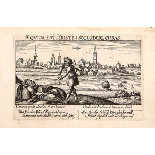
Aeqvum est, tristes secludere curas (Lianges.)
A very nice view of the city Lianges. With a verse in two languages underneath the picture.The poet and topographer from Comothau, Daniel Meisner (1585-1625), started his first publication entitled Thesaurus Philo-Politicus in Frankfurt in 1623, initially in parts, each one containing about fifty plans. The work was engraved circa 1623-1650, and printed 1678, and was published by Eberhard Kieser. In 1678 the collection of copperplates was sold to Paul Fü, who continued the printing under the t...
€60
Maker : MEISNER, D.
Place : Frankfurt
Date : 1623-1678
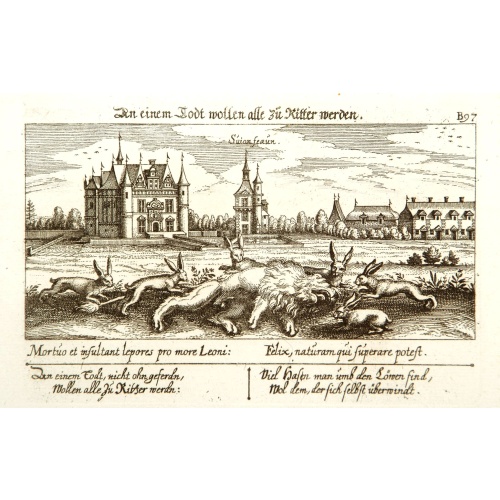
In einem Todt wollen alle zu Ritter werden.
A very nice view of a dead lion, surrounded by rabbits and in the background a French castle. With a verse in two languages underneath the picture. "In einem Todt, nicht ohn geferdn, wollen alle zu Ritter werdn: Viel Hasen man umh den Löwen find, wol dem, der sich selbst überwindt."The poet and topographer from Comothau, Daniel Meisner (1585-1625), started his first publication entitled Thesaurus Philo-Politicus in Frankfurt in 1623, initially in parts, each one containing about fifty plans. ...
€70
Maker : MEISNER, D.
Place : Frankfurt
Date : 1623-1678
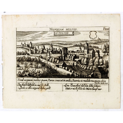
S. Iulius.
A very nice view of the castle of Saint Julius. On the foreground, several frogs are depicted. With a verse in two languages underneath the picture.The poet and topographer from Comothau, Daniel Meisner (1585-1625), started his first publication entitled Thesaurus Philo-Politicus in Frankfurt in 1623, initially in parts, each one containing about fifty plans. The work was engraved circa 1623-1650, and printed 1678, and was published by Eberhard Kieser. In 1678 the collection of copperplates was...
€60
Maker : MEISNER, D.
Place : Frankfurt
Date : 1623-1678
![S. Victor in Franckr. [Paris].](/uploads/cache/13781-500x500.jpg)
S. Victor in Franckr. [Paris].
A very nice view of St. Victor church in Paris. In the foreground, a night watchman is depicted. With a verse in Latin and German underneath the picture. The German text reads : "Auff dass nicht mög der Wandersman, Sein Füss verletzen uff dem plan, von dem Fusseisen so merct mich, er muss wandern fursichtiglich."
€60
Maker : MEISNER, D.
Place : Frankfurt
Date : 1623-1678
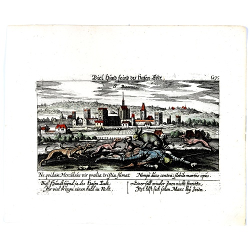
Vincennes - Viel hund Feind.des Hasen Todt.
A very nice picture representing Vincennes. With a verse in German and Latin. The German text reads : "Viel Hundt feind ja des Hasen Todr, Ihr viel bringn einen bald in Noht. Einer soll wieder zwen nicht streittn, Jtzt läst sich sehen Mars bey Zeitn." two languages underneath the picture.The poet and topographer from Comothau, Daniel Meisner (1585-1625), started his first publication entitled Thesaurus Philo-Politicus in Frankfurt in 1623, initially in parts, each one containing about fifty pl...
€70
Maker : MEISNER, D.
Place : Frankfurt
Date : 1623-1678
![Cordelirs in Franckr. [France].](/uploads/cache/13811-500x500.jpg)
Cordelirs in Franckr. [France].
A panoramic view of the town of Cordelirs (probably imaginary) with in center the church. On the foreground a man hunting a wolve. With a verse in two languages underneath the picture.The poet Daniel Meisner from Komotau started his Thesaurus Philo-Politicus. Das ist Politisches Schatzkästlein guter Herren und bestendiger Freund... in Frankfurt in 1623, initially in parts, each one containing about fifty plans. The work was printed work and was printed by Eberhard Kieser. In 1678 the collection...
€60
Maker : MEISNER, D.
Place : Frankfurt
Date : 1623-1678
![Cordelirs in Franckr. [France].](/uploads/cache/13799-500x500.jpg)
Cordelirs in Franckr. [France].
A very nice view of the town of Cordeliers. On the foreground, a man hunting a wolf is depicted. With a verse in German and Latin underneath the picture.The poet and topographer from Comothau, Daniel Meisner (1585-1625), started his first publication entitled Thesaurus Philo-Politicus in Frankfurt in 1623, initially in parts, each one containing about fifty plans. The work was engraved circa 1623-1650, and printed 1678, and was published by Eberhard Kieser. In 1678 the collection of copperplate...
€80
Maker : MEISNER, D.
Place : Frankfurt
Date : 1623-1678
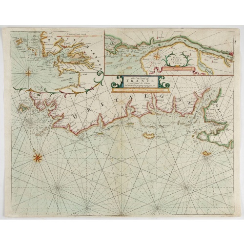
The Sea Coast of France from Ushent to Olone.
Chart showing the Brittany coast from Ushent to Ollone, with Belle-Ile. In insets : Rade de Brest and Mouth of the Loire between St. Nazaire and Nantes.Originally engraved by John Seller, here with the address "Sold by Ri. Mount at the Postern on Great Tower Hill LONDON". Mount and Page was a firm of religious and maritime publishers that flourished in the 18th century. The name became well-known worldwide as an imprint of nautical charts.The firm was founded in 1701 by Richard Mount (1654–172...
€550
Maker : MOUNT, R.. / PAGE, T.
Place : London, ca. 1680
Date : 1680
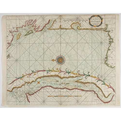
The Sea Coasts of France from Olone to Cape Machicaca in Biscay . . .
Detailed chart of Biscay Bay, showing the Coast of Brittany. The chart is oriented with north-east at the top and includes two large insets of the Loire River with Nantes and the complete coast of Brittany.Originally engraved by John Seller, here with the address "Sold by Ri. Mount at the Postern on Great Tower Hill LONDON". Mount and Page was a firm of religious and maritime publishers that flourished in the 18th century. The name became well-known worldwide as an imprint of nautical charts.The...
€550
Maker : MOUNT, R.. / PAGE, T.
Place : London
Date : ca. 1680
Veue de la ville, et fauxbourg de Salins…
Showing the town of Salins, a commune with salt works (Salines) in the Jura department in the region of Bourgogne-Franche-Comté in eastern France. With a key (1-15) in Latin and French to the most remarkable sights. Etching by A. F. Bauduins (Adrien François Baudouin) after Adam Frans van der Meulen (1632-1690) who was a Flemish Baroque painter specialising in battle scenes. He was active first in Brussels, where he was a pupil of Pieter Snayers, and from the 1660s onwards in Paris.His paint...
€700
Maker : MEULEN, Adam Frans van der.
Place : Paris
Date : 1680
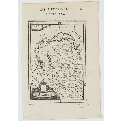
Savoye.
A charming map of Savoy. Title in a curtain draped at top. French text on verso.From the original 1683 text edition of "Description d'Univers. . ." by Allain Manesson Mallet (1630-1706), a well travelled military engineer and geographer who worked in 17th century France under King Louis XIV.Published by Denys Thierry.
€50
Maker : MANESSON MALLET, A.
Place : Paris
Date : 1683

François.
A charming engraving of a French couple in 17th-century dress.Title in a curtain draped at top. French text on verso.From the original 1683 text edition of "Description d'Univers. . ." by Allain Manesson Mallet (1630-1706), a well travelled military engineer and geographer who worked in 17th century France under King Louis XIV.Published by Denys Thierry.
€50
Maker : MANESSON MALLET, A.
Place : Paris
Date : 1683
-500x500.jpg)
Chamberi.
A charming view of Chambery. Title in a curtain draped at top. French text on verso.From the original 1683 text edition of "Description d'Univers. . ." by Allain Manesson Mallet (1630-1706), a well travelled military engineer and geographer who worked in 17th century France under King Louis XIV.Published by Denys Thierry.
€50
Maker : MANESSON MALLET, A.
Place : Paris, 1683
Date : 1683
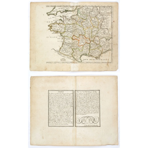
![Carte generale de France. [de l'Europe]](/uploads/cache/38442-500x500.jpg)
Carte generale de France. [de l'Europe]
A fine and uncommon early 17th century map of France printed from two copper plates. Engraved by Liébaux.From the French text edition of "Description d'Univers", 1683. by Allain Manneson Mallet (1630-1706), a well travelled military engineer and geographer who worked in 17th century France under King Louis XIV.
€80
Maker : MALLET, A.M.
Place : Paris
Date : 1683
![Ancienne Gavle. [de l'Europe]](/uploads/cache/38440-500x500.jpg)
Ancienne Gavle. [de l'Europe]
A fine and uncommon early 17th century map of France.From the French text edition of "Description d'Univers", 1683. by Allain Manneson Mallet (1630-1706), a well travelled military engineer and geographer who worked in 17th century France under King Louis XIV.
€50
Maker : MALLET, A.M.
Place : Paris
Date : 1683
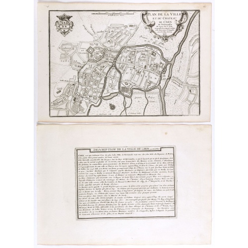
Plan de la ville et du château de Caën en Normandie.
Plan of the city of Caen, from Nicolas de Fer's "L'Atlas curieux ou le Monde réprésente dans des cartes. "The "Atlas Curieux" is a geographic encyclopedia of images and a celebration of the French Empire under the Sun King, with maps of French possessions in the western hemisphere, maps of France, with detailed views of the grand waterworks at Marly, views of the great palaces and chateaux, views and plans of the Paris Observatory, and samples of military architecture. Issued in six annual par...
€60
Maker : DE FER, N.
Place : Paris, 1705
Date : 1705
La France avec ses acquisitions jusqu'à l'année 1705.
An interesting small map of France by Nicolas de Fer. From his rare "Petit et Nouveau Atlas". The first edition was published in 1697 and was republished in 1705 and 1723. The finely engraved map is dated 1705 and was engraved by C. Inselin, the same engraver who engraved the maps in de Fer's later Atlas Curieux, published 1700-1705.
€75
Maker : DE FER, N.
Place : Paris
Date : 1705
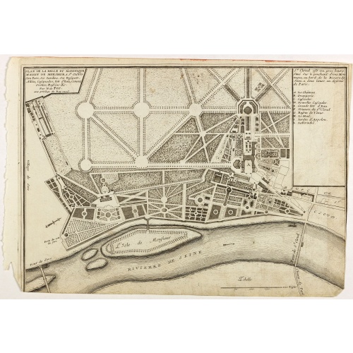
Plan de la belle et magnifique Maison de Monsieur A St Cloud . . .
Plan of the city of Saint Cloud, from Nicolas de Fer's "L'Atlas curieux ou le Monde réprésente dans des cartes. "The "Atlas Curieux" is a geographic encyclopedia of images and a celebration of the French Empire under the Sun King, with maps of French possessions in the western hemisphere, maps of France, with detailed views of the grand waterworks at Marly, views of the great palaces and chateaux, views and plans of the Paris Observatory, and samples of military architecture. Issued in six ann...
€60
Maker : DE FER, N.
Place : Paris
Date : 1705