
![[Lot of 8 maps of European Russia] Partie Septentrionale de la Russie Europeenne ou sont distinguees exactement toutes les Provinces](/uploads/cache/86005-500x500.jpg)
[Lot of 8 maps of European Russia] Partie Septentrionale de la Russie Europeenne ou sont distinguees exactement toutes les Provinces
[Lot of 8 maps of European Russia]- Partie Septentrionale de la Russie Européenne òu sont distinguées exactement toutes les Provinces (1753)- Carte des Pais Habites par les Samojedes et Ostiacs (1757)- 2x Carte de la Partie Septentrionale de la Russie Européenne- Partie Septentrionale de la Russie Europeenne ou sont distinguees exactement toutes les Provinces (1753)- Nouvelle Carte des Etats du Grand duc de Moscovite en Europe (1714)- Partie Meridionale de Moscovie Dressee Par G. de L’...
€600
Maker : BELLIN, Jacques Nicolas
Place : Paris
Date : 1757
![[Lot of 6] Carte de la Baye d'Hocsieu. Fukin. (3 Maps + 3 Gravure of China)](/uploads/cache/20019-500x500.jpg)
[Lot of 6] Carte de la Baye d'Hocsieu. Fukin. (3 Maps + 3 Gravure of China)
[Lot of 6 items]. (3 Maps +3 gravure )- Carte de la Baye d'Hocsieu et des Entrees de la Riviere de Chang Situees dans la Province de Fokyen. J.N.Berlin 1748- Carte de l’Isle de Cheu Chan ou Isle de Chusan de la Province de Che-Kiang Avec les Costes et Isles voisines- Carte de la Baye d'Hocsieu et des Entrées de la Riviere de Chang. Situées, Dans la Province de Fokyen- Tempel van Quang-Que-Myau- Temple Chinois- De Seije-Reedery, uit de HaldeA detailed small chart of the estuary of the Chiang...
€280
Maker : BELLIN, J. N.
Place : Amsterdam
Date : 1759
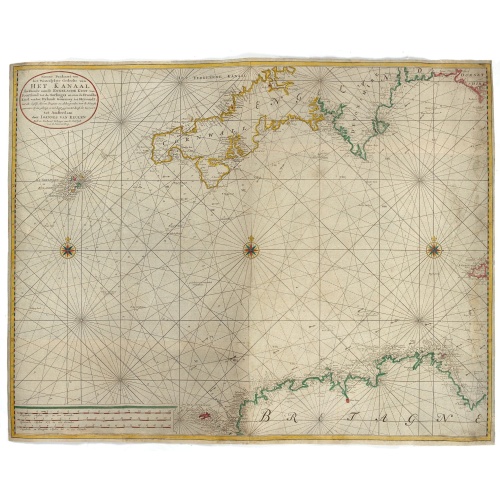
Nieuwe Paskaart van het Westerlykste Gedeelte van HET KANAAL strekkende aan de ENGELSCHE KUST van Poortland tot de Sorlinges. . .
Nieuwe Paskaart van het Westerlykste Gedeelte van HET KANAAL strekkende aan de ENGELSCHE KUST van Poortland tot de Sorlinges en aan de Fransche kust van het Eylandt Guernsey tot Heysandt. Ioannes van Keulen A RARE and decorative chart of the Channel between England and France. Decorated with a fine title cartouche: Nieuwe Paskaart van het Westerlykste Gedeelte van HET KANAAL strekkende aan de ENGELSCHE KUST van Poortland tot de Sorlinges en aan de Fransche Kust van het Eylandt Guernsey tot He...
€900
Maker : VAN KEULEN, J.
Place : Amsterdam
Date : 1760
![[Lot of 2 prints of Globes] La Sphere Terrestre / La Sphere Celeste.](/uploads/cache/84233-500x500.jpg)
[Lot of 2 prints of Globes] La Sphere Terrestre / La Sphere Celeste.
La Sphere Terrestre / La Sphere CelesteA set of two very fine prints of a Terrestrial Sphere and a celestial Sphere. With an description on both sides. All within an elaborate and very decorative border. Claude Buy de Mornas (d. 1783), géographe du roi (1764). Atlas Méthodique et Elémentaire de Géographie et d' Histoire, 1761, Atlas Historique et Géographique, 1762.[Lot of 2 prints]
€450
Maker : DE MORNAS, C.
Place : Paris, L.C. Desnos
Date : 1761

A Map of the most Inhabited part of New England containing the Provinces of Massachusetts Bay and New Hampshire, with the Colonies of Connecticut and Rhode Island.
A copper engraving in four sheets, published in Georges Louis Le Rouge, in his "Atlas Ameriqua in Septentrional Contenant les details des differentes provinces, de ce vaste continent, traduit des cartes levées par ordre du Gouvernement Britannique". This is a very close copy of the second edition, the second issue of the Jefferys-Green map, even down to the spelling, in the statement of sources, of Connecticut with 'k's (but translated into French). The title cartouche is also a straight copy, ...
€4.000
Maker : LE ROUGE, G. L.
Place : Paris, 1777
Date : Paris, 1777

Le Kaire (Cairo). Vue de la place Ezbekyeh, côté du sud
A very fine view of Cairo.
€500
Maker : DUTERTRE / BEAUGEAN.
Place : Paris
Date : ca 1780
![[Lot of 6 maps / prints] Schets van de Donkere Baai in Nieuw Zeeland 1773.](/uploads/cache/86004-500x500.jpg)
[Lot of 6 maps / prints] Schets van de Donkere Baai in Nieuw Zeeland 1773.
A map of Dusky Bay, visited by James Cook in 1773. From a Dutch edition of ‘Cook's voyages'. Schets van de Donkere Baai in Nieuw Zeeland 1773. Nicolas Bellin's map of the Marianas islands with an inset map of Guam. A view of Easter Island, of men of Hapahee in a fighting contest and a plan of a Tahitian war proha. Together 6 maps / views of the Pacific Ocean.Captain James Cook (1728-79), explorer, circumnavigator and hydrographer. Three voyages, 1768-71, 1772-75 and 1776-79. From 1778 on p...
€350
Maker : James Cook
Place : London
Date : ca. 1790
![[Lot of 2 maps] Important plan of Port Bucarelli 1384 / Chart of the entrance of "Bassin de L'Quest", La Perouse. 1709](/uploads/cache/20473-500x500.jpg)
[Lot of 2 maps] Important plan of Port Bucarelli 1384 / Chart of the entrance of "Bassin de L'Quest", La Perouse. 1709
Chart of the entrance of "Bassin de L'Quest", La Perouse. 1709 / With antique print of Alaska] Pirogue du port des Francais. / Pirogue, trouvee au port des Francais. 5958 / [Antique map of Alaska] Plan der Haven van Namganoodha in het eiland van Oonolaska. 2665 / Antique detail chart of the Nootka Channel] Schets van het Kanaal van Nootka. 3860. Plus 6 prints of natives of Alaska and their utensils. A plan of Port Bucarelli, Jean François Galoup, Comte de la Pérouse (1741-88), outstanding Fren...
€350
Maker : La Pérouse, J.B.G. Comte de.
Place : Paris
Date : 1797
![[Lot of 5 maps] Kaart van de noord-west kust van Amerika en de noord-oost kust van Asia.](/assets/images/image-loading.svg)
[Lot of 5 maps] Kaart van de noord-west kust van Amerika en de noord-oost kust van Asia.
- Kaart van de noord-west kust van Amerika en de noord-oost kust van Asia. Opgenoomen in de Jaaren 1778 en 1779.Captain James Cook (1728-79), explorer, circumnavigator and hydrographer. Three voyages, 1768-71, 1772-75 and 1776-79. From 1778 on printed editions of ' Captain Cook's Travels' appeared in English, Italian, French and Dutch east coast. From a Dutch edition of Cook's voyages'.- Carte d'une Partie DE L'AMERIQUE SEPTRIONALE qui comprendles POSSESSIONA ANGLAISES. This map depicts colonia...
€300
Maker : COOK, J.
Place : Leiden
Date : 1795-1803
-500x500.jpg)
Geographie Universelle dite de Crozat.
A nice geographical dictionair with maps of the world and the continents and maps of European countries. Lacks the maps of France and of the Turkish empire.
€280
Maker : Crozat.
Place : Paris
Date : 1823
![[Lot of 7 Flower prints] Talauma mutabilis. flower Talauma mutabilis from 'FLORA MALESIANA' Arckenhausen del. / Hutz Lith.](/uploads/cache/85382-500x500.jpg)
[Lot of 7 Flower prints] Talauma mutabilis. flower Talauma mutabilis from 'FLORA MALESIANA' Arckenhausen del. / Hutz Lith.
The flower Talauma mutabilis from 'FLORA MALESIANA'. Talauma mutabilis by Karl Ludwig von Blume (9 June 1796, Braunschweig – 3 February 1862, Leiden) was a German-Dutch botanist. (3454)Lot of 7 flower prints.- Talauma mutabilis - Sobralia Macrantha- Détails de la liane femelle du Chili- Liane femelle du Chili- Détails de la lianne màle du Chili- Dianthus sinensis heddewigii- Dianthus sinensis laciniatus
€300
Maker : BLUME, Carl Ludwig. von
Place : Germany
Date : 1829
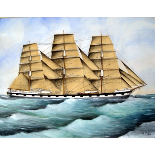
Original Maritime painting of the 'Cape Horn' , a so-called captain's ship drawing by R. Takes
A fine example of a so-called 'captain's portrait' of a clipper-ship under full sail. The name of the ship at the bow reads "Cape Horn" Signed in the lower right corner: R.Takes.
€750
Maker : TAKES, R.
Place : unknown
Date : c. 1850
[Original drawing: Fisher's ships on the beach of Scheveningen.]
Unique pencil drawing: Typical Dutch beach life with flat-bottomed ships on the beach of Scheveningen. Signed in the lower right corner and on the back site with P.A. Beretta (Petrus Augustus Beretta)
€450
Maker : BERETTA, Petrus Augustus Artist
Place : The Netherlands
Date : c. 1850
Painting made by a sailor, signed W. Welman.
Painting made by a sailor, signed W.Welman.
€250
Maker : WELMAN, W.
Place : Unknown
Date : c.1960
![[Dutch provo Propaganda Poster] De Vrije Maagd Radio](/uploads/cache/86256-500x500.jpg)
[Dutch provo Propaganda Poster] De Vrije Maagd Radio
Published in 1969, the year of the student unrest in Europe.Het jaar van de studenten opstanden in Europese landen! DUTCH PROVO POSTERAmsterdammers, luister niet naar de met het kapitaal Kollaborerende Hilversumse radio, maar naar de vrije maagd: 225 mtr middengolfkom naar het Spui beleger de belegeraars !
€200
Maker : Rob Stolk en H. Langhout
Place : Amsterdam
Date : 1969
![[Lot of 3] Celestial chart depicting astronomical division of the earth.](/uploads/cache/84235-500x500.jpg)
[Lot of 3] Celestial chart depicting astronomical division of the earth.
A chart depicting the astronomical division of the earth. With on both sides a descriptionary text. All within an elaborate and very decorative border. A very fine item.Claude Buy de Mornas (d. 1783), géographe du roi (1764). Atlas Méthodique et Elémentaire de Géographie et d' Histoire, 1761, Atlas Historique et Géographique, 1762. A chart depicting the astronomical division of the earth. With on both sides a descriptionary text. All within an elaborate and very decorative border. A very fi...
€250
Maker : BUY DE MORNAS, C.
Place : Paris, L.C. Desnos
Date : 1761.