
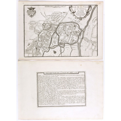
Plan de la ville et du château de Caën en Normandie.
Plan of the city of Caen, from Nicolas de Fer's "L'Atlas curieux ou le Monde réprésente dans des cartes. "The "Atlas Curieux" is a geographic encyclopedia of images and a celebration of the French Empire under the Sun King, with maps of French possessions in the western hemisphere, maps of France, with detailed views of the grand waterworks at Marly, views of the great palaces and chateaux, views and plans of the Paris Observatory, and samples of military architecture. Issued in six annual par...
€60
Maker : DE FER, N.
Place : Paris, 1705
Date : 1705

Les Gouvernements generaux de l'Isle de France et de Champagne, ou se trouvent les generalitez de Paris et Chaalons.
Map of the Isle de France and Champagne regions, from Nicolas de Fer's "L'Atlas curieux ou le Monde réprésente dans des cartes. "The "Atlas Curieux" is a geographic encyclopedia of images and a celebration of the French Empire under the Sun King, with maps of French possessions in the western hemisphere, maps of France, with detailed views of the grand waterworks at Marly, views of the great palaces and chateaux, views and plans of the Paris Observatory, and samples of military architecture. I...
€60
Maker : DE FER, N.
Place : Paris
Date : 1705
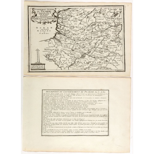
Gouvernement general de Picardie . . .
Map of the Picardie region, from Nicolas de Fer's "L'Atlas curieux ou le Monde réprésente dans des cartes. "The "Atlas Curieux" is a geographic encyclopedia of images and a celebration of the French Empire under the Sun King, with maps of French possessions in the western hemisphere, maps of France, with detailed views of the grand waterworks at Marly, views of the great palaces and chateaux, views and plans of the Paris Observatory, and samples of military architecture. Issued in six annual p...
€60
Maker : DE FER, N.
Place : Paris
Date : 1705
Gouvernement de Dauphiné, Generalité de Grenoble.
Map of the Dauphiné region, from Nicolas de Fer's "L'Atlas curieux ou le Monde réprésente dans des cartes. "The "Atlas Curieux" is a geographic encyclopedia of images and a celebration of the French Empire under the Sun King, with maps of French possessions in the western hemisphere, maps of France, with detailed views of the grand waterworks at Marly, views of the great palaces and chateaux, views and plans of the Paris Observatory, and samples of military architecture. Issued in six annual ...
€60
Maker : DE FER, N.
Place : Paris
Date : 1705
La France avec ses acquisitions jusqu'à l'année 1705.
An interesting small map of France by Nicolas de Fer. From his rare "Petit et Nouveau Atlas". The first edition was published in 1697 and was republished in 1705 and 1723. The finely engraved map is dated 1705 and was engraved by C. Inselin, the same engraver who engraved the maps in de Fer's later Atlas Curieux, published 1700-1705.
€75
Maker : DE FER, N.
Place : Paris
Date : 1705
Plan general de Chantilly . . .
Plan of the city of Chantilly, from Nicolas de Fer's "L'Atlas curieux ou le Monde réprésente dans des cartes. "The "Atlas Curieux" is a geographic encyclopedia of images and a celebration of the French Empire under the Sun King, with maps of French possessions in the western hemisphere, maps of France, with detailed views of the grand waterworks at Marly, views of the great palaces and chateaux, views and plans of the Paris Observatory, and samples of military architecture. Issued in six annua...
€60
Maker : DE FER, N.
Place : Paris
Date : 1705
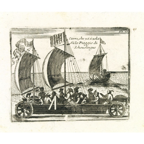
Carro, che uà à vela Su le Piagge di Schevelingue.
Italian version of Prince Maurits' sailing carriage designed by Simon Stevin. The big sailing-carriage could seat 28 persons and could reach a speed of seven miles per hour. The Prince often took his guests on a ride on the beaches of Scheveningen.
$225
Maker : CORONELLI, V.
Place : Venice
Date : 1707

Nieuwe en Nette Afteekening van het Eyland Corsica en het Eyland Elba vertoonende alle desselfs Havenen, Steeden en Rivieren . . .
Highly decorative large sea chart of Corsica, Sardinia and Elba, including multiple sailing ships, compass roses, cartouche, coat of arms, rhumb lines, topographical details, soundings, etc.Inset map of "Eyland Zlba of Ilva int Groot". Includes rhumb lines, topographical details, soundings, and a host of other details.
$4.000
Maker : VAN KEULEN, G.
Place : Amsterdam
Date : ca. 1710
(Clermont, Brioude, Le Puy, etc.)
Rare miniature map including the towns of Clermont, Brioude, Le Puy, etc. From "Le theatre De Bellone, Contenant 48. nouvelles Cartes Geographiques, Des Païs-Bas Espagnols, Provinces-Unies, haute & basse Allemagne. . .". This rare atlas contained maps relating to the War of Spanish Succession. Published in Amsterdam by the widow of P. Schenk.
€60
Maker : SCHENK, P.
Place : Amsterdam
Date : 1710
Ludovicus. XV rex chrisitan franciae et navarrae nat d:15. febr. 1710.
Portrait of Ludovicus XV, set in a decorative border.In lower part "Jo. Es. Nilson, inv et excutiv Aug V. et à Paris chez Rosselin Rue St. Jaques a l'Autel Saumur". Prepared by Johann Esaias Nilson (1721-88), 'the German Watteau'. Nilson was part of a family of artists and established himself as the leading Augsburg artist of his day, whose influence extended across publishing, art academies, a role as court painter, and the decorative arts (especially ceramics).Louis XV, known as Louis the Bel...
€50
Maker : NILSON, J.E.
Place : Augsburg, Paris
Date : 1710
Le Royaume de France..
Lovely small map of France with decorative title cartouche and a panel in the upper right corner listing local rulers.From Le Nouveau et Curieux Atlas Geographique et Historique.. by Jacques Chiquet.Together with an engraved French text sheet entitled Le Royaume de France.
€75
Maker : CHIQUET, J.
Place : Paris
Date : 1719
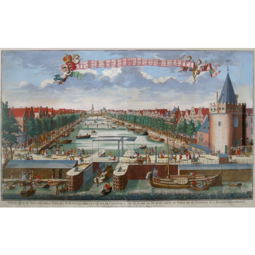
Beschrijving Gezicht van den Ykant af bezyden den Schreiers hoex Toren langs de Keulsche en Geldersche Kaei naer de Nieuwe Markt
This large engraving (560x920mm.) comes from a are series of 25 beautiful large views of Amsterdam and gives a colorful picture of the life and business of the city at the beginning of the 18th century. The print gives a view of the cityscape and architecture of that time. It also shows daily manners and customs and all kinds of scenes take place; There is a fight to the left of the bridge in the foreground (now Prins Hendrik Kade), while in front of the Scheierstoren quiet citizens read the not...
$2.000
Maker : DE LETH, H.
Place : Amsterdam
Date : ca 1720
Carte du Gouvernement Ecclesiastique de France Divise en ses Archeveschez, Eveschez, Archidiaconnez, Archipretrez, Doyennez, et Parroisses.
This impressive plate provides a comprehensive list of the ecclesiastical divisions in the country with their corresponding coats of arms. A small inset map depicts the location of the various churches across France (95 x 105mm.)Zacharie Chatelain (d.1723) was the father of Henri Abraham (1684-1743) and Zacharie Junior (1690-1754).They worked as a partnership publishing the Atlas Historique, Ou Nouvelle Introduction A L’Histoire … under several different Chatelain imprints, depending on the ...
€55
Maker : CHATELAIN, H.
Place : Amsterdam, 1720
Date : 1720
Nouvelle Carte des Differents Etats de la Monarchie Françoise Sous Iule Cesar, Sous les Rois de la Premiere, de la Seconde . . .
Four maps of France surrounded by historical and genealogical information to the history, chronology, ancient and modern genealogy of the french monarchy.Henri Abraham Chatelain (1684 – 1743) was a Huguenot pastor of Parisian origins. He lived consecutively in Paris, St. Martins, London (c. 1710), the Hague (c. 1721) and Amsterdam (c. 1728). He is best known as a Dutch cartographer and more specifically for his cartographic contribution in the seminal seven volume Atlas Historique, published f...
€75
Maker : CHATELAIN, H.
Place : Amsterdam
Date : 1720

Les Provinces des Pais Bas Autrichiens contenants en XXIV Feuilles les comtées d'Artois, de Flandres, de Hainaut, de Namur et des Duchées de Luxembourg…
Rare wall map of the Catholic of Austrian Low Countries, roughly the southern part of present-day The Netherlands, Belgium and Luxembourg. Map has some large cartouches, ships in the North Sea.
$1.500
Maker : SEUTTER, M.
Place : Augsburg, 1725
Date : 1725
Les Provinces Unies des Pays Bas, suivant les nouvelles observations. . .
With decorative title cartouche upper left corner.This example is unusual in having the additional separately engraved decorative framework border around the map, the resultant visual effect being particularly striking. The frame border was prepared with a blank center so that the map could be over-printed on that area.These separately engraved border frames appear much more uncommon than the standard edition without border frames. From Le Nouveau Theatre du Monde, ou la Geographie Royale.
$250
Maker : AA, P. van der
Place : Amsterdam
Date : 1728

Kaerte en Afbeeldinge vande Geheele Jurisdictie van Stantdarbuyten Gelegen in de Generaliteit onder Marquisaet van Bergen op den Zoom
With a large title cartouche with signature of the maker Adriaan van der Ende, : Kaerte en Afbeeldinge vande Geheele Jurisdictie van Stantdarbuyten Gelegen in de Generaliteit onder Marquisaet van Bergen op den Zoom, gemaekt, en in den Jare van 1733, 1734, 1735 gemeten by my ondergetz… Willemstadt den 8 Julij 1737 Adr: van Enden.Adriaan van de Ende was a surveyor, appointed by the Council of Brabant in 1720, then living in Heyningen. Was later living and active in Willemstad.Other manuscript m...
$2.500
Maker : VAN DE ENDEN, A.
Place : Willemstadt
Date : 1737
[Lot of 5 maps of the mouth of the Gironde river] Carte des Entrees et Cours de la Gironde
A large sea chart of the mouth and course of the Gironde river as far inland as Bordeaux. Decorated with three cartouches.Jacques Nicolas Bellin (1702-720) was the most important French hydrographer of the 18th century. Sea-atlas 'Hydrographique Français' , 1756-65, atlas to accompany Prévost d' Exile's ' Histoire. des Voyages', 1738-75. A lot of 5 maps of the mouth of the Gironde river.- Carte des Entrees et Cours de la Gironde ((96x65 cm)- Carte du Gouvernent de Guyenne et Gascogne- Gou...
€350
Maker : BELLIN, J. N.
Place : Paris
Date : c. 1740
[Lot of 3 maps] Carte de la Souveraineté de NEUCHATEL et VALLANGIN. Plus Mercator's and Blaeu's maps of the Wiflispurgergou]
Map of the lake of Neuchatel by Covens & Mortier. After the death of the widow of Pieter Mortier in 1719, the firm continued till 1778 as Covens & Mortier. They published numerous atlases and pocket atlases, using maps after de l' Isle and Map of the lake of Neuchatel.Plus Mercator's and Blaeu's maps of the Wiflispurgergou. [Lot of 3 maps]- Carte de la Souveraineté de NEUCHATEL et VALLANGIN- das WIFLISPUR-Gergow- Das WIFLISPUR-Gergow Blaeu 1610
€350
Maker : COVENS, J. / MORTIER, C.
Place : Amsterdam
Date : c. 1745
III. Carte du C.té de Haynaut et des Frontieres du C.té de Flandre..
Attractive small map encompassing part of the Nord, between Douai and Valenciennes.From Atlas Portatif Universel, by Robert de Vaugondy.Unrecorded state with erased date. Page 14c outside border top right. Mary Sponberg Pedley does not mention a state without date.
€50
Maker : VAUGONDY, R. de
Place : Paris
Date : after 1748