

Kaerte en Afbeeldinge vande Geheele Jurisdictie van Stantdarbuyten Gelegen in de Generaliteit onder Marquisaet van Bergen op den Zoom
With a large title cartouche with signature of the maker Adriaan van der Ende, : Kaerte en Afbeeldinge vande Geheele Jurisdictie van Stantdarbuyten Gelegen in de Generaliteit onder Marquisaet van Bergen op den Zoom, gemaekt, en in den Jare van 1733, 1734, 1735 gemeten by my ondergetz… Willemstadt den 8 Julij 1737 Adr: van Enden.Adriaan van de Ende was a surveyor, appointed by the Council of Brabant in 1720, then living in Heyningen. Was later living and active in Willemstad.Other manuscript m...
$2.500
Maker : VAN DE ENDEN, A.
Place : Willemstadt
Date : 1737

't Hooge Heemraedschap van Delfland met alle de Steden, Dorpen, Ambachten, Litmaten, Polders, (etc.).
The so-called Kruquius map is a wall-map of the Delfland water board district. The map consists of 25 engraved map sheets. Several maps flanked by fine large armorial cartouches. All sheets together cover a wall map with a total area of 230 x 280 cm. The map was often bound in a rich gilted calf binding and presented as gifts to important persons. The atlas than included also the overview map. According to Prof. Koeman "Thanks to the quality of the cartography (a “sensitive” scale of 1:10,00...
€3.750
Maker : KRUIKIUS, N. / J.
Place : Delft
Date : 1712-1750
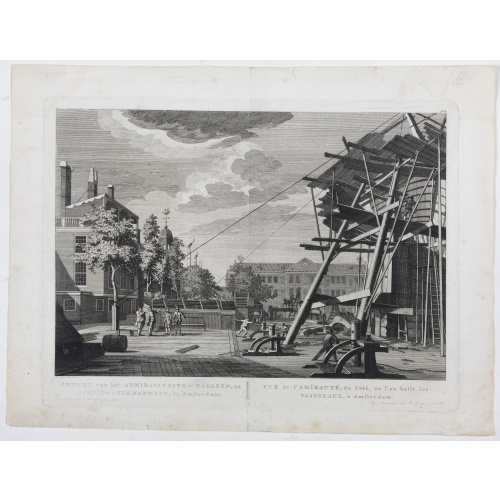
Gezicht van het Admiraliteits-Magazyn en Scheeps Timmerwerf.
Formerly the V.O.C. warehouse and arsenal for the Admiralty of Amsterdam, now-a-days the Scheepvaartmuseum (Maritime Museum). Taken from the "Atlas of Amsterdam".
$300
Maker : FOUQUET jr., P.
Place : Amsterdam
Date : 1780
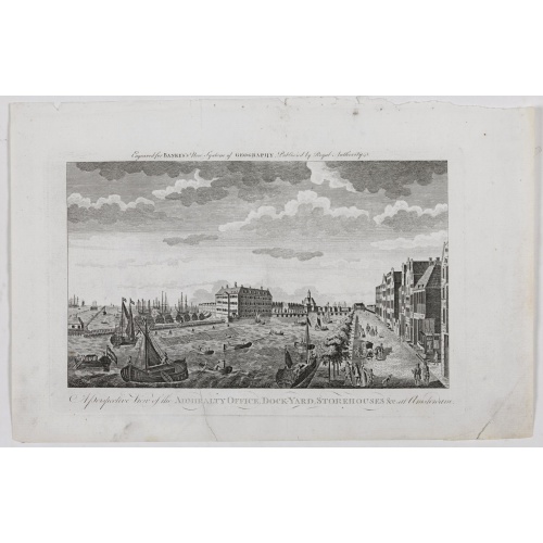
A Perspective View of the Admiralty Office, Dock-Yard, Storehouses &c. at Amsterdam.
Decorative engraving giving good detail of the intense activity in the Amsterdam dockyards.Engraved for BANKES's New System of Geography
$300
Maker : BANKES
Place : Amsterdam
Date : 1780
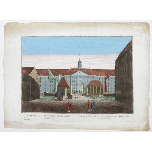
Vue du Magazin de la Compagnie des Indes Orientales. . .
So-called optical print of the formerly the V.O.C. warehouse and arsenal for the Admiralty of Amsterdam, now-a-days the Scheepvaartmuseum (Maritime Museum).In the eighteenth and nineteenth centuries there were many popular speciality establishments in Paris, Augsburg and London which produced optical viewing devices and special engravings to be viewed through them. In the 18th century the optical print or vue optique came into existence, whose exaggerated converging lines were intended to produc...
$550
Maker : ANONYMOUS
Place : France
Date : 1780
Plan de la ville de Maestricht avec ses attaques commandées par M. le maréchal de Saxe, depuis le 15 avril jusqu'au 3 may 1748 . . .
A plan of Maastricht rising after the capture of the city by the French troops led by the Marshal of Saxony. The city was besieged between 15 April and 3 May 1748, during the War of Succession of Austria.With numbered key (1-53).
$600
Maker : JAILLOT, J.
Place : Paris
Date : 1781
Partie septentrionale des Pays-Bas comprenant .. des provinces unies. . .
Finely and crisply engraved map of Netherlands.Venetian edition of Giles Didier Robert De Vaugondy's map from Atlas Universel printed in 1776-84.Ornamental title cartouche in the upper right corner, including a large vessel in the North Sea.
$450
Maker : SANTINI, P. / REMONDINI, M.
Place : Venice, 1776 - 1784
Date : 1784
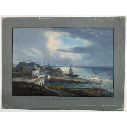
Vue de Gattweick et de l'embouchure du Rhin, dans la Mer du Nord.
Very decorative view of Katwijk. Signed lower right, Louis Bleuler au chateau de Laufen . Original design by Louis Bleuer. This gouache was the model for his aquatint in his famous book 80 Rheingegenden published in 1826.
$1.500
Maker : BLEULER, L.
Place : gERMANY
Date : 1820
-500x500.jpg)
Holland & Belgium.
An attractive steel engraved map of Holland and Belgium. Map flanked by France and Prussia. Duchy of Luxembourg included. Many place names and physical features shown. 4 mileage scales given.The Arrowsmith family members were among the most respected and influential cartographers of the nineteenth century. Taken from 'The London Atlas of Universal Geography…' John Arrowsmith (1790-1873) joined his uncle, Aaron Arrowsmith in mapmaking in London in 1810. Upon the death of his uncle in 1823, the ...
$110
Maker : ARROWSMITH, John
Place : London, 1839
Date : 1839
Regno de' Paesi-Bassi compresa la Olanda . . . / La Svizzera . . .
Two rare and detailed maps of The Netherland (210 x 230mm. ) and Switzerland (140 x 230mm.) According to the title cartouche, prepared by J.A.Buchon and A de La Sage for l'Atlante Storico, Letterario, Biografico, Archeologico. . . with attributions by Giambatista Albrizzi.Lower left a color-key, giving good detail and information. We were not able to find references to the publisher, engraver or author of this map. Uncommon and in very good condition.
$60
Maker : TASSO, G.
Place : Venice, 1840
Date : 1840
Provincia ecclesiastica di Utrecht Nell' Olanda (Tav LXIII)
This large-format map of The Netherlands with its different dioceses. The map is finely engraved and beautifully colored and was prepared by Girolamo Petri, a lawyer who served as a senior official within the Vatican’s State Secretariat, the arm of the Holy See responsible for managing its relationships with foreign powers. The map shows the various dioceses, which are each distinguished by their own bright colors, marking their seats, as well as other major towns. While key geographical featu...
$300
Maker : PETRI Girolamo
Place : Rome
Date : 1858