
ID: 161
Closed
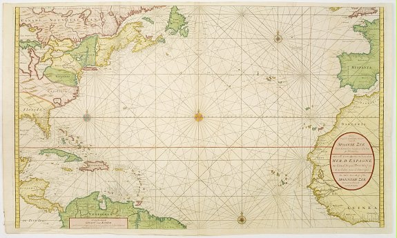
Nieuwe Wassende Graade Zee Kaart over de Spaanse Zee Vant Kanaal tot 't Eyland Cuba in Westindia. . .
BuyNow for $3.000
- Maker :
- VAN KEULEN, G.
- Place :
- Amsterdam
- Date :
- 1728
- Color :
- Colored
- Height mm.:
- 583
- Width mm.:
- 975
- Condition :
- Printed from two plates. Repair of a tear next to crossing of two folds, hardly notable.
- Bibliography :
- Koeman: Atlantes Neerlandici, Vol.IV, (212).
- Seller's ref. :
- 00018
This item is offered by Paulus_Swaen_Old_Maps
See other Items from this seller- Postage
-
Standard Shipping
$0 to France
- Select Country
- Zip/Post Code
- Quantity
$3.000
Description
¤ Engraved by I.van Anse. A very representative example of a Dutch chart of the Atlantic, showing the north-east coast of America, the coasts of Africa and Europe and South America, including Florida and the West Indies.Gerard issued ca. 40 charts of this exceptionally large format. Collections of these large-size charts were issued in the shining sea-torch and as separate atlases.

Les Provinces des Pais Bas Autrichiens contenants en XXIV Feuilles les comtées d'Artois, de Flandres, de Hainaut, de Namur et des Duchées de Luxembourg…
Rare wall map of the Catholic of Austrian Low Countries, roughly the southern part of present-day The Netherlands, Belgium and Luxembourg. Map has some large cartouches, ships in the North Sea.
$1.500
Maker : SEUTTER, M.
Place : Augsburg, 1725
Date : 1725

Eastern passage to China. sheet 1.
James Horsburgh early chart of the coasts of Java, Bali, Lombok, with part of Sulawesi, and Borneo. Insets of "Sketch of Bally Strait", Sketch of Lombock Strait", Plan of Allas Strait", "Sketch of Sappy Strait".The chart shows depth soundings & both topographical and hydrographical details and proposed sailing directions in the Sunda Straits. Filled with several coastal profiles, which were of great help for the sailor.In top Horsburgh thanks for the aid he has gotten for preparing this chart : ...
$3.000
Maker : HORSBURGH, JAMES, F.R.S
Place : London
Date : 1824

Straat Riouw onder opzicht van de commissie tot verbetering der Indische Zeekaarten..
Very large and rare so-called Blue Back chart centered on the strait passing between the Riau Islands. It contains an inset map with enlarged details of Riouw Harbor on Bintang Island.Coastal profiles are shown in the lower-left corner of the chart.The chart is prepared by W.H.Dittlof Tjassens, P.A.J.Bloijs van Treslong Prins and J.van Gogh during an expedition in 1840 by the ship Nehalennia under the command of Captain F.G.van der Plaat. The chart is engraved by D.Veelwaard Jr. And published in...
$1.250
Maker : HULST VAN KEULEN, Wed.G.
Place : Amsterdam
Date : 1843

Belchrijuinghe vande zee custen van Engelandt. . .
A rare Dutch text edition of this detailed early chart of the northern coast of England. West to the top. The mileage cartouche has no Latin captures. Decorated by a colorful title cartouche and scale cartouche, one compass rose, and several vessels. An early Dutch text edition of this landmark contribution to the science of navigation. Waghenaer's own experiences as a pilot along European coasts were used to compile the Spiegel der Zeevaerdt, the first edition of which was published in Dutch at...
$3.000
Maker : WAGHENAER, L. J.
Place : Leiden, Plantijn
Date : 1585
Postage & Shipping
-
Item Location
Terms and conditions - Item Location
- Amsterdam, , Netherlands
- Ships To
- United States, United Kingdom, Albania, Argentina, Armenia, Australia, Azerbaijan, Bahamas, Belgium, Bermuda, Cambodia, Canada, Chile, China, Croatia, Cyprus, Czech Republic, Denmark, Estonia, Finland, France, Germany, Gibraltar, Greece, Greenland, Guatemala, Hong Kong, Iceland, India, Indonesia, Israel, Italy, Japan, Latvia, Lithuania, Luxembourg, Malta, Mexico, Monaco, Netherlands, Norway, Singapore, Spain, Sweden, Switzerland, Turkey
- Pick-ups
- No pick-ups
This item is owned and offered by the seller Paulus_Swaen_Old_Maps - All items are available for immediate sale, offered subject to prior sale.
Invoices are created by the seller by using our shopping cart or be prepared by the seller the day following the order and are emailed to you.
Items offeres by different sellers are invoiced separately.
Shipping fees are extra. The buyer is responsible for all applicable taxes, including any VAT, customs clearance, import duties, or equivalent costs arriving at the customer's home border. Payment is due on receipt of the invoice. The item(s) are shipped as soon as possible after receipt of your payment.
Before buying please read the complete Terms Conditions of Sale.
- Payment Methods
- Visa, Mastercard, Bank Transfer, American Express, iDEAL, PayPal, Google Pay
- Returns Accepted
- No
Post Message
Feel free to ask the seller a question. Please note that the seller could be located in an area with a different time zone. Our seller will do their best to respond within 24 hours.Post your message below.
Sign in to ask the seller a question.
