

III. Carte du C.té de Haynaut et des Frontieres du C.té de Flandre..
Attractive small map encompassing part of the Nord, between Douai and Valenciennes.From Atlas Portatif Universel, by Robert de Vaugondy.Unrecorded state with erased date. Page 14c outside border top right. Mary Sponberg Pedley does not mention a state without date.
€50
Maker : VAUGONDY, R. de
Place : Paris
Date : after 1748
France.
Uncommon miniature map of France, engraved by J.Spilbury for "A New General and Universal Atlas Containing Forty five Maps by Andrew Dury".This miniature atlas published during the Seven Years' War.The maps are typical for the period and well executed with great clarity. The plates are engraved in 1761 and in 1763 a second edition was presumably produced for the French market having all but nine with a French titles added above the top.
€50
Maker : DURY, A. / SAYER, R. / KITCHIN, T.
Place : London
Date : 1761-1763
INTERIEUR DE LA CATHEDRALE A CHARTRES. Dessiné d'après nature par Chapuy. Lith. Par Bachelier.
Original lithograph of the inside of the cathedral situated in Chartres. Lithographed by Bachelier after a design by Chapuy and printed in Paris by Lemercier, Bernard Cie.
€50
Maker : CHAPUY
Place : Paris
Date : 1844
Savoye.
A charming map of Savoy. Title in a curtain draped at top. French text on verso.From the original 1683 text edition of "Description d'Univers. . ." by Allain Manesson Mallet (1630-1706), a well travelled military engineer and geographer who worked in 17th century France under King Louis XIV.Published by Denys Thierry.
€50
Maker : MANESSON MALLET, A.
Place : Paris
Date : 1683
Les environs de Mons, Beaumont, Chimay, Valenciennes, Condé, &c.
Detailed map of Northern France, centered on Valenciennes and Mons. The map was prepared by Jean Baptiste de Bouge (1757-1833), who prepared one of the first very detailed maps of Belgium.Map 9 of a large wall map of Belgium.
€50
Maker : DE BOUGE, J-B.
Place : Bruxelles
Date : 1789 - 1793
Bresse.
Early map of Eastern France and part of Switzerland. Geneva in upper right corner. With Latin text on verso. Engraved by Petrus Kaerius. Shortly after the publication of big folio-atlases the need was apparently felt for a smaller sized atlas, one that would be handier and, above all, cheaper. Joh. Cloppenburgh published in 1630 a atlas based on Mercator's pocket map, but in a slightly larger size. He published a Latin text edition in 1632.
€50
Maker : CLOPPENBURGH, J.E.
Place : Amsterdam
Date : 1632
Topographie historique du vieux Paris / Plan de restitution Feuille V bis.
Copper engraved plan centered on gardens of the Louvre by Jean-Joseph Sulpis (1826–1911) after a model by Adolphe Berty. Plate 5bis from "Topographie historique du vieux Paris". The publication was started by Adolphe Berty and continued by H. Legrand and L.-M. Tisserand, Th. Vacquer and Camille Platon.
€50
Maker : BERTY, A.
Place : Paris
Date : 1866-1897
INTERIEUR DE L'EGLISE SAINT OUEN A ROUEN. Dessiné d'après nature par Chapuy. Lith. Par Arnout. Fig par Bayot.
Original lithograph of the inside of Saint Ouen chruch, situated in Rouen. Lithographed by Arnout and Adolphe-Jean-Baptist Bayot (Alessandria 1810 - 1866) after a design by Chapuy and printed in Paris by Lemercier, Bernard Cie.
€50
Maker : CHAPUY
Place : Paris
Date : 1844
François.
A charming engraving of a French couple in 17th-century dress.Title in a curtain draped at top. French text on verso.From the original 1683 text edition of "Description d'Univers. . ." by Allain Manesson Mallet (1630-1706), a well travelled military engineer and geographer who worked in 17th century France under King Louis XIV.Published by Denys Thierry.
€50
Maker : MANESSON MALLET, A.
Place : Paris
Date : 1683
Dépt. De La Haute Loire. N°42.
Map of the Upper Loire region in France.Lovely map from one of the last decorative atlases of the nineteenth century.The rather simple map is framed by medallion portraits and coats of arms, and is set against a background of scenes of the countryside, products and activities indigenous to the region filling the foreground.Victor Levasseur's "Atlas National Illustre" and "Atlas Universel Illustre" are among the last great decorative atlases published. This map comes from the Atlas National Illus...
€50
Maker : LEVASSEUR, V.
Place : Paris
Date : A. Combette, 1852
Chamberi.
A charming view of Chambery. Title in a curtain draped at top. French text on verso.From the original 1683 text edition of "Description d'Univers. . ." by Allain Manesson Mallet (1630-1706), a well travelled military engineer and geographer who worked in 17th century France under King Louis XIV.Published by Denys Thierry.
€50
Maker : MANESSON MALLET, A.
Place : Paris, 1683
Date : 1683
TOMBEAU DU DUC DE BREZE, DANS LA CATHEDRALE DE ROUEN. Dessiné d'après nature par Chapuy. Lith. par Monthelier. Fig. par Bayot.
Original lithography of the tomb of the duke of Brézé, in the cathedral of Rouen. Lithographed by Jules Monthelier (1801-1883) and Adolphe-Jean-Baptist Bayot (Alessandria 1810 - 1866) after a design by Chapuy and printed in Paris by Lemercier, Bernard Cie.
€50
Maker : CHAPUY
Place : Paris
Date : 1844
In einem Todt. . . [ Chateau Chenonceaux ]
A very nice depiction of Chateau Chenonceaux near Tours, France within the foreground is a dead lion, surrounded by rabbits. With a verse in two languages underneath the picture.The poet and topographer from Comothau, Daniel Meisner (1585-1625), started his first publication entitled Thesaurus Philo-Politicus in Frankfurt in 1623, initially in parts, each one containing about fifty plans. The work was engraved circa 1623-1650, and printed 1678, and was published by Eberhard Kieser. In 1678 the ...
€50
Maker : MEISNER, D.
Place : Frankfurt
Date : 1623-1678
Ludovicus. XV rex chrisitan franciae et navarrae nat d:15. febr. 1710.
Portrait of Ludovicus XV, set in a decorative border.In lower part "Jo. Es. Nilson, inv et excutiv Aug V. et à Paris chez Rosselin Rue St. Jaques a l'Autel Saumur". Prepared by Johann Esaias Nilson (1721-88), 'the German Watteau'. Nilson was part of a family of artists and established himself as the leading Augsburg artist of his day, whose influence extended across publishing, art academies, a role as court painter, and the decorative arts (especially ceramics).Louis XV, known as Louis the Bel...
€50
Maker : NILSON, J.E.
Place : Augsburg, Paris
Date : 1710
Ancienne Gavle. [de l'Europe]
A fine and uncommon early 17th century map of France.From the French text edition of "Description d'Univers", 1683. by Allain Manneson Mallet (1630-1706), a well travelled military engineer and geographer who worked in 17th century France under King Louis XIV.
€50
Maker : MALLET, A.M.
Place : Paris
Date : 1683
La partie orientale de la Grande Aquitaine.
Map taken from "Geographique Theater de l'Europe …, a rare work by the Jesuit priest Briet.
€50
Maker : BRIET, Ph.
Place : Paris
Date : 1649
Francia divisa in provincie.
Rare map of France, from "Atlante Novissimo ad uso Dei Giovani Studiosi Contenuto In Carte XXVII.", published by Giovanni Zempel in Rome, ca. 1780.The map is based on Claude Buffier (1661-1737) geography.
€50
Maker : ZEMPEL, G.
Place : Rome
Date : 1780
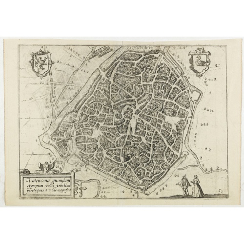
Valencena . . .
Eye-bird view of Valenciennes.
€55
Maker : GUICCIARDINI, L.
Place : Anvers
Date : 1590
Carte du Gouvernement Ecclesiastique de France Divise en ses Archeveschez, Eveschez, Archidiaconnez, Archipretrez, Doyennez, et Parroisses.
This impressive plate provides a comprehensive list of the ecclesiastical divisions in the country with their corresponding coats of arms. A small inset map depicts the location of the various churches across France (95 x 105mm.)Zacharie Chatelain (d.1723) was the father of Henri Abraham (1684-1743) and Zacharie Junior (1690-1754).They worked as a partnership publishing the Atlas Historique, Ou Nouvelle Introduction A L’Histoire … under several different Chatelain imprints, depending on the ...
€55
Maker : CHATELAIN, H.
Place : Amsterdam, 1720
Date : 1720
Cordelirs in Franckr. [France].
A panoramic view of the town of Cordelirs (probably imaginary) with in center the church. On the foreground a man hunting a wolve. With a verse in two languages underneath the picture.The poet Daniel Meisner from Komotau started his Thesaurus Philo-Politicus. Das ist Politisches Schatzkästlein guter Herren und bestendiger Freund... in Frankfurt in 1623, initially in parts, each one containing about fifty plans. The work was printed work and was printed by Eberhard Kieser. In 1678 the collection...
€60
Maker : MEISNER, D.
Place : Frankfurt
Date : 1623-1678