
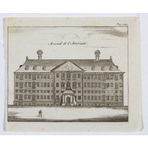
Arcenal de l'Amirauté.
A decorative print of the 'T Landts Magazyn , or 'Scheepvaart Museum' (Naval Museum).
$80
Maker : ANONYMOUS
Place : Amsterdam
Date : ca. 1700
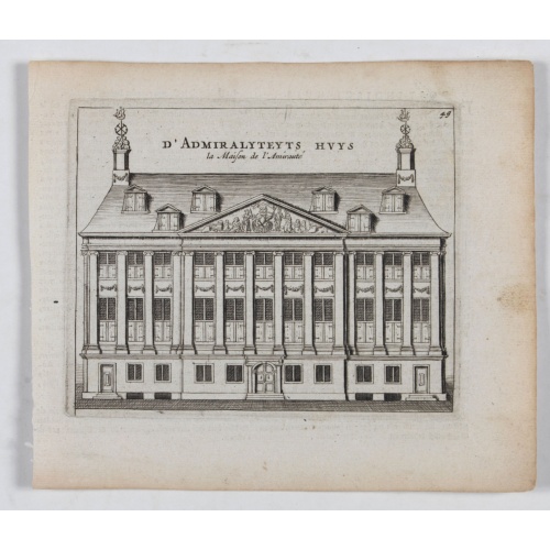
D' Admiralyteyts Huys - La maison de l'Amirauté.
Decorative print of the "D'Admiralyteits Huys", Het Prinsenhof, of the Dutch East India Company VOC. Located at the Oudezijds Voorburgwal 195-199, Amsterdam.
$150
Maker : ANONYMOUS
Place : Amsterdam
Date : ca. 1700
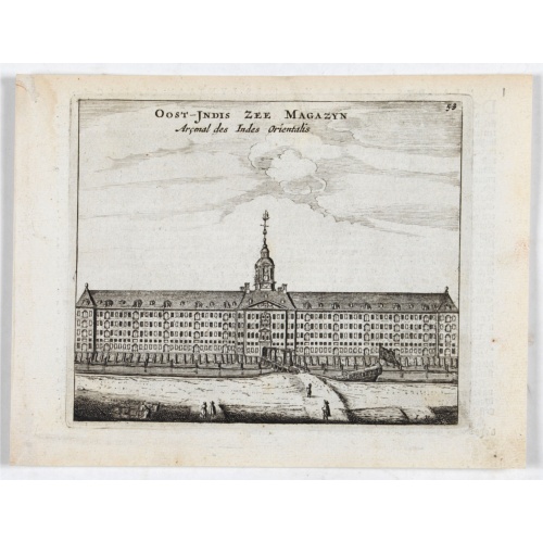
Oost-Indis Zee Magazyn - Arçenal des Indes Orientalis.
Decorative view of the East Indian Arsenal, now-a-says the Maritime Museum.
$150
Maker : ANONYMOUS
Place : Amsterdam
Date : ca. 1700
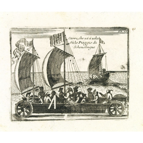
Carro, che uà à vela Su le Piagge di Schevelingue.
Italian version of Prince Maurits' sailing carriage designed by Simon Stevin. The big sailing-carriage could seat 28 persons and could reach a speed of seven miles per hour. The Prince often took his guests on a ride on the beaches of Scheveningen.
$225
Maker : CORONELLI, V.
Place : Venice
Date : 1707
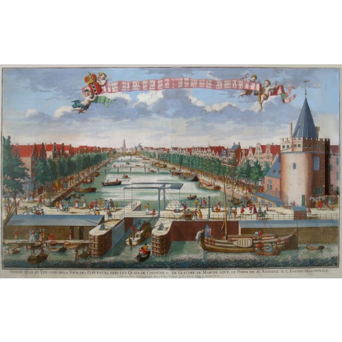
Beschrijving Gezicht van den Ykant af bezyden den Schreiers hoex Toren langs de Keulsche en Geldersche Kaei naer de Nieuwe Markt
This large engraving (560x920mm.) comes from a are series of 25 beautiful large views of Amsterdam and gives a colorful picture of the life and business of the city at the beginning of the 18th century. The print gives a view of the cityscape and architecture of that time. It also shows daily manners and customs and all kinds of scenes take place; There is a fight to the left of the bridge in the foreground (now Prins Hendrik Kade), while in front of the Scheierstoren quiet citizens read the not...
$2.000
Maker : DE LETH, H.
Place : Amsterdam
Date : ca 1720

Les Provinces des Pais Bas Autrichiens contenants en XXIV Feuilles les comtées d'Artois, de Flandres, de Hainaut, de Namur et des Duchées de Luxembourg…
Rare wall map of the Catholic of Austrian Low Countries, roughly the southern part of present-day The Netherlands, Belgium and Luxembourg. Map has some large cartouches, ships in the North Sea.
$1.500
Maker : SEUTTER, M.
Place : Augsburg, 1725
Date : 1725

Kaerte en Afbeeldinge vande Geheele Jurisdictie van Stantdarbuyten Gelegen in de Generaliteit onder Marquisaet van Bergen op den Zoom
With a large title cartouche with signature of the maker Adriaan van der Ende, : Kaerte en Afbeeldinge vande Geheele Jurisdictie van Stantdarbuyten Gelegen in de Generaliteit onder Marquisaet van Bergen op den Zoom, gemaekt, en in den Jare van 1733, 1734, 1735 gemeten by my ondergetz… Willemstadt den 8 Julij 1737 Adr: van Enden.Adriaan van de Ende was a surveyor, appointed by the Council of Brabant in 1720, then living in Heyningen. Was later living and active in Willemstad.Other manuscript m...
$2.500
Maker : VAN DE ENDEN, A.
Place : Willemstadt
Date : 1737
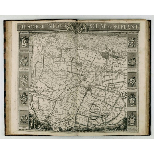
't Hooge Heemraedschap van Delfland met alle de Steden, Dorpen, Ambachten, Litmaten, Polders, (etc.).
The so-called Kruquius map is a wall-map of the Delfland water board district. The map consists of 25 engraved map sheets. Several maps flanked by fine large armorial cartouches. All sheets together cover a wall map with a total area of 230 x 280 cm. The map was often bound in a rich gilted calf binding and presented as gifts to important persons. The atlas than included also the overview map. According to Prof. Koeman "Thanks to the quality of the cartography (a “sensitive” scale of 1:10,00...
€3.750
Maker : KRUIKIUS, N. / J.
Place : Delft
Date : 1712-1750
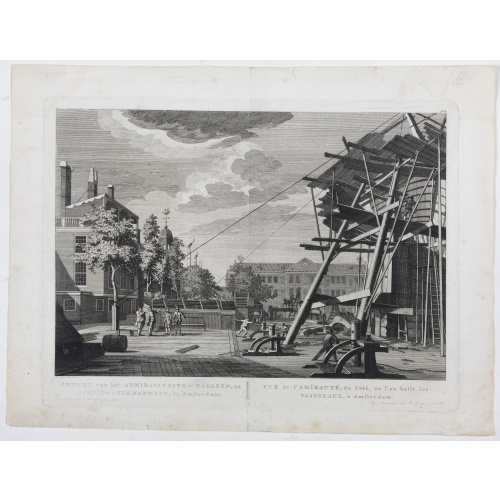
Gezicht van het Admiraliteits-Magazyn en Scheeps Timmerwerf.
Formerly the V.O.C. warehouse and arsenal for the Admiralty of Amsterdam, now-a-days the Scheepvaartmuseum (Maritime Museum). Taken from the "Atlas of Amsterdam".
$300
Maker : FOUQUET jr., P.
Place : Amsterdam
Date : 1780
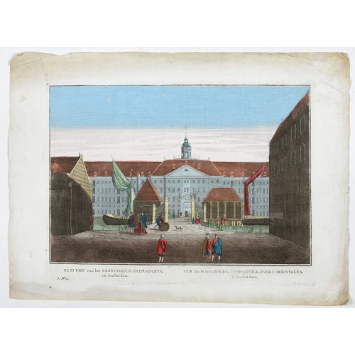
Vue du Magazin de la Compagnie des Indes Orientales. . .
So-called optical print of the formerly the V.O.C. warehouse and arsenal for the Admiralty of Amsterdam, now-a-days the Scheepvaartmuseum (Maritime Museum).In the eighteenth and nineteenth centuries there were many popular speciality establishments in Paris, Augsburg and London which produced optical viewing devices and special engravings to be viewed through them. In the 18th century the optical print or vue optique came into existence, whose exaggerated converging lines were intended to produc...
$550
Maker : ANONYMOUS
Place : France
Date : 1780
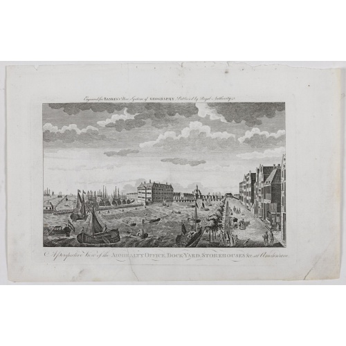
A Perspective View of the Admiralty Office, Dock-Yard, Storehouses &c. at Amsterdam.
Decorative engraving giving good detail of the intense activity in the Amsterdam dockyards.Engraved for BANKES's New System of Geography
$300
Maker : BANKES
Place : Amsterdam
Date : 1780
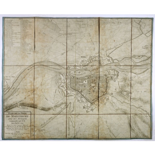
Plan de la ville de Maestricht avec ses attaques commandées par M. le maréchal de Saxe, depuis le 15 avril jusqu'au 3 may 1748 . . .
A plan of Maastricht rising after the capture of the city by the French troops led by the Marshal of Saxony. The city was besieged between 15 April and 3 May 1748, during the War of Succession of Austria.With numbered key (1-53).
$600
Maker : JAILLOT, J.
Place : Paris
Date : 1781
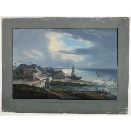
Vue de Gattweick et de l'embouchure du Rhin, dans la Mer du Nord.
Very decorative view of Katwijk. Signed lower right, Louis Bleuler au chateau de Laufen . Original design by Louis Bleuer. This gouache was the model for his aquatint in his famous book 80 Rheingegenden published in 1826.
$1.500
Maker : BLEULER, L.
Place : gERMANY
Date : 1820
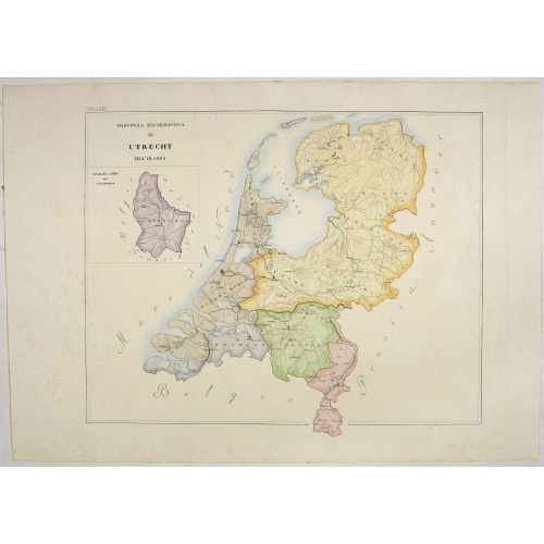
Provincia ecclesiastica di Utrecht Nell' Olanda (Tav LXIII)
This large-format map of The Netherlands with its different dioceses. The map is finely engraved and beautifully colored and was prepared by Girolamo Petri, a lawyer who served as a senior official within the Vatican’s State Secretariat, the arm of the Holy See responsible for managing its relationships with foreign powers. The map shows the various dioceses, which are each distinguished by their own bright colors, marking their seats, as well as other major towns. While key geographical featu...
$300
Maker : PETRI Girolamo
Place : Rome
Date : 1858