
![[Lot of 3] Celestial chart depicting astronomical division of the earth.](/uploads/cache/84235-500x500.jpg)
[Lot of 3] Celestial chart depicting astronomical division of the earth.
A chart depicting the astronomical division of the earth. With on both sides a descriptionary text. All within an elaborate and very decorative border. A very fine item.Claude Buy de Mornas (d. 1783), géographe du roi (1764). Atlas Méthodique et Elémentaire de Géographie et d' Histoire, 1761, Atlas Historique et Géographique, 1762. A chart depicting the astronomical division of the earth. With on both sides a descriptionary text. All within an elaborate and very decorative border. A very fi...
€250
Maker : BUY DE MORNAS, C.
Place : Paris, L.C. Desnos
Date : 1761.
![[Lot of 6] Carte de la Baye d'Hocsieu. Fukin. (3 Maps + 3 Gravure of China)](/uploads/cache/20019-500x500.jpg)
[Lot of 6] Carte de la Baye d'Hocsieu. Fukin. (3 Maps + 3 Gravure of China)
[Lot of 6 items]. (3 Maps +3 gravure )- Carte de la Baye d'Hocsieu et des Entrees de la Riviere de Chang Situees dans la Province de Fokyen. J.N.Berlin 1748- Carte de l’Isle de Cheu Chan ou Isle de Chusan de la Province de Che-Kiang Avec les Costes et Isles voisines- Carte de la Baye d'Hocsieu et des Entrées de la Riviere de Chang. Situées, Dans la Province de Fokyen- Tempel van Quang-Que-Myau- Temple Chinois- De Seije-Reedery, uit de HaldeA detailed small chart of the estuary of the Chiang...
€280
Maker : BELLIN, J. N.
Place : Amsterdam
Date : 1759
![[Lot of 5 maps] Kaart van de noord-west kust van Amerika en de noord-oost kust van Asia.](/assets/images/image-loading.svg)
[Lot of 5 maps] Kaart van de noord-west kust van Amerika en de noord-oost kust van Asia.
- Kaart van de noord-west kust van Amerika en de noord-oost kust van Asia. Opgenoomen in de Jaaren 1778 en 1779.Captain James Cook (1728-79), explorer, circumnavigator and hydrographer. Three voyages, 1768-71, 1772-75 and 1776-79. From 1778 on printed editions of ' Captain Cook's Travels' appeared in English, Italian, French and Dutch east coast. From a Dutch edition of Cook's voyages'.- Carte d'une Partie DE L'AMERIQUE SEPTRIONALE qui comprendles POSSESSIONA ANGLAISES. This map depicts colonia...
€300
Maker : COOK, J.
Place : Leiden
Date : 1795-1803
![[Lot of 7 Flower prints] Talauma mutabilis. flower Talauma mutabilis from 'FLORA MALESIANA' Arckenhausen del. / Hutz Lith.](/uploads/cache/85382-500x500.jpg)
[Lot of 7 Flower prints] Talauma mutabilis. flower Talauma mutabilis from 'FLORA MALESIANA' Arckenhausen del. / Hutz Lith.
The flower Talauma mutabilis from 'FLORA MALESIANA'. Talauma mutabilis by Karl Ludwig von Blume (9 June 1796, Braunschweig – 3 February 1862, Leiden) was a German-Dutch botanist. (3454)Lot of 7 flower prints.- Talauma mutabilis - Sobralia Macrantha- Détails de la liane femelle du Chili- Liane femelle du Chili- Détails de la lianne màle du Chili- Dianthus sinensis heddewigii- Dianthus sinensis laciniatus
€300
Maker : BLUME, Carl Ludwig. von
Place : Germany
Date : 1829
![[Lot of 2 maps] Important plan of Port Bucarelli 1384 / Chart of the entrance of "Bassin de L'Quest", La Perouse. 1709](/uploads/cache/20473-500x500.jpg)
[Lot of 2 maps] Important plan of Port Bucarelli 1384 / Chart of the entrance of "Bassin de L'Quest", La Perouse. 1709
Chart of the entrance of "Bassin de L'Quest", La Perouse. 1709 / With antique print of Alaska] Pirogue du port des Francais. / Pirogue, trouvee au port des Francais. 5958 / [Antique map of Alaska] Plan der Haven van Namganoodha in het eiland van Oonolaska. 2665 / Antique detail chart of the Nootka Channel] Schets van het Kanaal van Nootka. 3860. Plus 6 prints of natives of Alaska and their utensils. A plan of Port Bucarelli, Jean François Galoup, Comte de la Pérouse (1741-88), outstanding Fren...
€350
Maker : La Pérouse, J.B.G. Comte de.
Place : Paris
Date : 1797
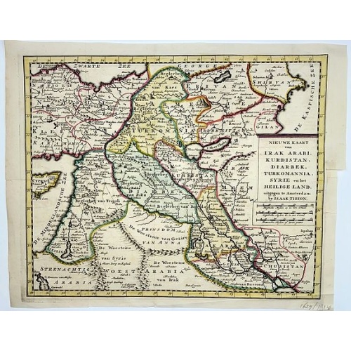
Irak, Arabi, Kurdistan, Diarbek, Turkomania, Syrie en het Heilige Land.
Isaak Tirion's map of the Near East. His 'Nieuwe en beknopte handatlas' saw 6 editions between before 1740 and after 1784. Also the 'Atlas van de Nederlandse Provintien' (1739-57) and ' Atlas van Zeeland' (1760).
€350
Maker : TIRION, Isaak.
Place : Amsterdam
Date : ca. 1750
![[Lot of 3 maps] Carte de la Souveraineté de NEUCHATEL et VALLANGIN. Plus Mercator's and Blaeu's maps of the Wiflispurgergou]](/uploads/cache/85967-500x500.jpg)
[Lot of 3 maps] Carte de la Souveraineté de NEUCHATEL et VALLANGIN. Plus Mercator's and Blaeu's maps of the Wiflispurgergou]
Map of the lake of Neuchatel by Covens & Mortier. After the death of the widow of Pieter Mortier in 1719, the firm continued till 1778 as Covens & Mortier. They published numerous atlases and pocket atlases, using maps after de l' Isle and Map of the lake of Neuchatel.Plus Mercator's and Blaeu's maps of the Wiflispurgergou. [Lot of 3 maps]- Carte de la Souveraineté de NEUCHATEL et VALLANGIN- das WIFLISPUR-Gergow- Das WIFLISPUR-Gergow Blaeu 1610
€350
Maker : COVENS, J. / MORTIER, C.
Place : Amsterdam
Date : c. 1745
![[Set of 2 maps of Caspian Sea.] Carte marine de la Mer Caspiene. Levee suivant les ordres de S.M. Czariene, P](/uploads/cache/86020-(1)-500x500.jpg)
[Set of 2 maps of Caspian Sea.] Carte marine de la Mer Caspiene. Levee suivant les ordres de S.M. Czariene, P
Guillaume de l' Isle (1675-1724), Royal Geographer, was the most influential cartographer of the first quarter of the 18th century. ' Atlas de Géographie' (1700-12), posthumous ' Atlas Nouveau' (1730). After the death of the widow of Pieter Mortier in 1719, the firm continued till 1778 as Covens & Mortier. They published numerous atlases and pocket atlases, using maps after de l' Isle and Jaillot.Two charts together depicting the Caspian Sea; the northern part of the Caspian Sea with insets dep...
€350
Maker : Guillaume Delisle
Place : Paris
Date : 1721
![[Lot of 6 maps / prints] Schets van de Donkere Baai in Nieuw Zeeland 1773.](/uploads/cache/86004-500x500.jpg)
[Lot of 6 maps / prints] Schets van de Donkere Baai in Nieuw Zeeland 1773.
A map of Dusky Bay, visited by James Cook in 1773. From a Dutch edition of ‘Cook's voyages'. Schets van de Donkere Baai in Nieuw Zeeland 1773. Nicolas Bellin's map of the Marianas islands with an inset map of Guam. A view of Easter Island, of men of Hapahee in a fighting contest and a plan of a Tahitian war proha. Together 6 maps / views of the Pacific Ocean.Captain James Cook (1728-79), explorer, circumnavigator and hydrographer. Three voyages, 1768-71, 1772-75 and 1776-79. From 1778 on p...
€350
Maker : James Cook
Place : London
Date : ca. 1790
![[Lot of 5 maps of the mouth of the Gironde river] Carte des Entrees et Cours de la Gironde](/uploads/cache/86010-500x500.jpg)
[Lot of 5 maps of the mouth of the Gironde river] Carte des Entrees et Cours de la Gironde
A large sea chart of the mouth and course of the Gironde river as far inland as Bordeaux. Decorated with three cartouches.Jacques Nicolas Bellin (1702-720) was the most important French hydrographer of the 18th century. Sea-atlas 'Hydrographique Français' , 1756-65, atlas to accompany Prévost d' Exile's ' Histoire. des Voyages', 1738-75. A lot of 5 maps of the mouth of the Gironde river.- Carte des Entrees et Cours de la Gironde ((96x65 cm)- Carte du Gouvernent de Guyenne et Gascogne- Gou...
€350
Maker : BELLIN, J. N.
Place : Paris
Date : c. 1740
![[Lot of 13 prints of the Chinese court] Habillement de l' Empereur dela Chine & des Dames de son Palais aves quel...](/uploads/cache/IMG_08451-500x500.jpg)
[Lot of 13 prints of the Chinese court] Habillement de l' Empereur dela Chine & des Dames de son Palais aves quel...
Prints of the Chinese court.[Lot of 13 prints]- Salle Imperiale De L'Audience, tiree de Nieuhof (1760)- Pagodes ou Statues; Miniso ou la Volupté (1749- Pagodes ou statues du temple. 1. Un defenseur de la patrie.- Mandians vacabonds / Autres mandais - Pagodes ou statues du temple- Salle Imperiale de l'Audience tiree de Nieuhof- Laboureurs (1750)- Cour du Grand Mogol- l'ambassadeur conduit a l’audience- Le Grand Throne Imperial.- Mandians Vagabonds. Autres Mandians / Zwervende Schooije...
€400
Maker : BELLIN, J.N.
Place : Amsterdam
Date : 1750
![[Lot of 14 maps of Germany] Nova Totius Germaniae Descriptio.](/uploads/cache/86021-500x500.jpg)
[Lot of 14 maps of Germany] Nova Totius Germaniae Descriptio.
Willem Blaeu, founder of the famous publishing firm. Originally publishing pilot-guides, he issued his first atlas, 'Atlantis Appendix', in 1630, followed by his "Theatrum Orbis Terrarum" or "Novus Atlas" in 1635.Willem Blaeu's map of Germany. From the French edition of Willem Blaeu's atlas "Theatrum". With 13 other map of general Germany by Tirion, Bachienne and Bonne.[Lot of 14 maps]- Nova Totius Germaniae Descriptio. Blaeu 1634- Nieuwe kaart van Duitsland verdeelt in zyn Thien Kre...
€500
Maker : BLAEU, W.
Place : Amsterdam
Date : 1635
![[Lot of 15 maps/plans of northern France] Gouvernement d' Orleans et la Generalite divisee en ses Elections.](/uploads/cache/16682-500x500.jpg)
[Lot of 15 maps/plans of northern France] Gouvernement d' Orleans et la Generalite divisee en ses Elections.
Alexis-Hubert Jaillot (1632-1712), French cartographer. He joined the Sanson heirs and redrew Nicolas Sanson's maps on a larger scale. 'Atlas Nouveau' (1674), sea-atlas ' Le Neptune François' (1693).An attractive large-format map depicting Orleans and vincinity. Embellished with a large title-cartouche and a cartouche with scales.Newly engraved for the counterfeited edition of the ' Atlas Nouveau', published by Pieter Mortier in Amsterdam. Ref.: Pastoureau, Les Atlas Français XVIe-XVIIe Siècl...
€500
Maker : Jaillot, A.-H. / P. Mortier.
Place : Amsterdam
Date : 1693
Nieuwe Pascaert van de Kust van Maroca en Zanhaga. . .
A very fine sea chart of the west coast of Morocco between C.Cantin tot C.Bajador and the Canary Islands, Lanzerote and Fuerteventura. With a very large decorative title-cartouche and an inset depicting Porto de Nao en Po. de Cavallos on Lanzerote. Rhumb lines. Johannes van Keulen is the founder of the successful van Keulen firm that published charts, pilot guides and sea-atlases for over 2 centuries. In 1680, he published his immensely popular 'Zee Atlas of te Water Werelt'.
€600
Maker : VAN KEULEN, Johannes.
Place : Amsterdam
Date : ca 1685
![[Lot of 10 maps] Carte Nouvelle de la Grande Tartary.](/uploads/cache/85969-500x500.jpg)
[Lot of 10 maps] Carte Nouvelle de la Grande Tartary.
Antique map of Asian Russia] Carte Nouvelle de la Grande Tartarie ou de l'Empire du Grand Cham. With 10 maps / views of Asian Russia- Carte Nouvelle de la Grande Tartarie ou de L’empire du Grand Cham (1719)- Baie de castries settee sur la cote orientale de tartarie (1797)- Carte du Kamtchatka Dressee et Gravée par Laurent (1757)- 2x Gezichten der kust van Asiën.- Gezichten der kust van Kamtchatka.- Carte de la Tartarie Occidentale, Pour servir à l'Histoire Générale (1749)- IImperium Rus...
€700
Maker : CHATELAIN, H.
Place : Amsterdam
Date : 1720 - 1730
![[Lot of 6 Maps of Germany] PALATINATUS BAVARIAE.](/uploads/cache/19093-500x500.jpg)
[Lot of 6 Maps of Germany] PALATINATUS BAVARIAE.
[Lot of 6 Maps of Germany]- La Basse Partie Du Cercle Du Haut Rhein divisé en tous ses Estats et Souverainetés. 1696 - (875x580 mm)- Wirtenberg Ducatus (Hondius) 1638 - (494x415 mm)- Partie Orientale Du Palatinat et Eslectorat Du Rhein. Les Eveschés De Spire, De Wormes et Le Comté de Linange. 1692 - (565x430 mm)An attractive map of Bayern, embellished with a fine strapwork title-cartouche and a cartouche with scales.From the Latin, 1613 edition.Gerard Mercator (1512-94). His ' Atlas sive...
€700
Maker : MERCATOR, G. / HONDIUS, J.
Place : Amsterdam
Date : 1619
![[Lot of 8 maps and prints] Norvegiae Maritimae ab Elf-burgo ad Dronten / Pascaert van Noorwegen streckende van Elf-burg tot Dronten.](/uploads/cache/84130-500x500.jpg)
[Lot of 8 maps and prints] Norvegiae Maritimae ab Elf-burgo ad Dronten / Pascaert van Noorwegen streckende van Elf-burg tot Dronten.
Norvegiae Maritimae ab Elf-burgo ad Dronten / Pascaert van Noorwegen streckende van Elf-burg tot Dronten.Frederick de Wit's fine sea chart of southern Norway. An attractive sea chart of southern Norway and Sweden, richly embellished with a stunning large decorative title cartouche, showing the drying of cod. A lot of 8 maps including:-Carte du Detroit de Waeigats ou de Nassau 1758 -Partie de la Mer Glaciale 1758 -RVGIA VSEDO MIAE ET IVLINAE -Carte du Spits-Berg 1758 -Carte Des Pais Habites par�...
€900
Maker : DE WIT, Frederick.
Place : Amsterdam
Date : 1675
![[Lot of 17 maps] L' ISLE DE FRANCE Pariensis agri descriptio. Francois de la Hoeye fecit, Jean le Clerc excud.](/uploads/cache/86212-500x500.jpg)
[Lot of 17 maps] L' ISLE DE FRANCE Pariensis agri descriptio. Francois de la Hoeye fecit, Jean le Clerc excud.
The map of Ile de France which Jean Leclerc added in his re-issue of Maurice Bouguereau's atlas 'Theatre Francois' , as ' La Theatre geographique de France' in 1619. An uncommon and decorative map.[Lot of 17] maps of F R A N C E- L'Isle de France, Parisiensis agri descrip(tio). - Gouvernemens de Picardie, de Boulonnois, et d’Artois (1768)- V. Descrittione del Regno della Gallia (1598)-La France Divisée en ses quarante Gouvernamens Généraux et Militaire.- - Topographia aug. Turon. duca...
€1.000
Maker : Jean Leclerc
Place : Paris
Date : 1619