
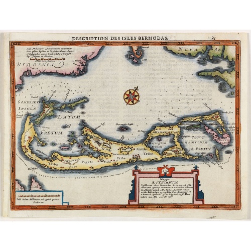
Description des Isles Bermudas.
Map of Bermuda from the rare Cloppenburg edition slightly larger format and more scarce edition of the Mercator/Hondius "Atlas Minor". Engraved by Pieter Van Den Keere.The Cloppenburg edition "Atlas Sive Cosmographicae Meditationes De Fabrica Mundi Et Fabricati Figura", was continued for a couple of years but seems to have been suppressed after 1636 ... (Koeman Atlantes Neerlandici).Based on the 1595 Abraham Ortelius map, but with added decoration.
€800
Maker : MERCATOR, G. / CLOPPENBURGH, J.E.
Place : Amsterdam
Date : 1630
![[Collective suicide under Spanish rule.]](/uploads/cache/40480-500x500.jpg)
[Collective suicide under Spanish rule.]
The natives of Hispaniola, who saw no end to the fearful oppression of Spanish rule, preferred death. So many, devoid of all hope, went into the woods to kill their children and hang themselves. After taking certain natural poisons, the women followed their husbands to death by means of the noose. Others threw themselves down mountains, jumped into the sea or into rivers, while some died by self-imposed starvation or even stabbed themselves to death with razor sharp stone knives:In 1631 Johann L...
€80
Maker : GOTTFRIED, J.L. / DE BRY.
Place : Frankfurt, M.Merian
Date : 1633

Particularitez Curieuses de l'Ile de St. Christophle et de la Province de Bemarin . . .
Six meticulously detailed and engraved scenes of the island of St. Kitts, also known as Saint Christopher, and the province of Bemarin, indigenous plants, animals, reptiles, fish, crustaceans and insects.On a single sheet from Volume Six of Chatelain's "Atlas Historique".From left to right, top, the illustrations depict the French General's palace on St. Kitts, Indians visiting the French, and a landscape in Bemarin Province. Zacharie Chatelain (d.1723) was the father of Henri Abraham (1684-1743...
€95
Maker : CHATELAIN, H.
Place : Amsterdam
Date : 1720
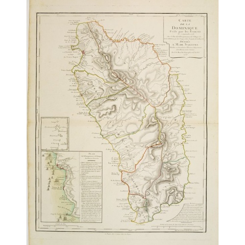
Carte de la Dominique Prise par les Francois le 7 Septembre 1778. Avec le Plan du Debarquement et de l'Attaque des Forts et Batteries par les Troupes et Les Fregates de sa Majeste
A rare map of St. Dominica, with insets of Charlotteville with its attack by the French on 7 September 1778 on the British. Also small inset map of the Caribbean islands from Antigua till Grenada. With dedication to de Sartine, a French official.
€500
Maker : BUACHE, S.
Place : Paris
Date : 1780
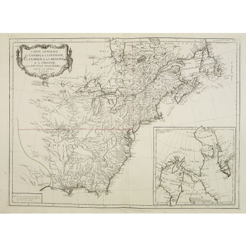
Carte Générale du Canada, de la Louisiane, de la Floride, de la Caroline..
Map of the eastern part of the United States and Canada. With inset map of Hudson and Baffin bays. in the lower right corner.Venetian edition of d'Anville's map, from "Atlas Universel" printed in 1776-84.Noteworthy topographical detail is shown, with particular focus on the Great Lakes. Lake Superior is shown attached to a convoluted river system reaching across the continent reminiscent of the Riviere Longue of Baron Lahontan's memoirs.On the Gulf Coast the region of Tecas (Texas) is named with...
€750
Maker : SANTINI, P. / REMONDINI, M.
Place : Venice
Date : 1784
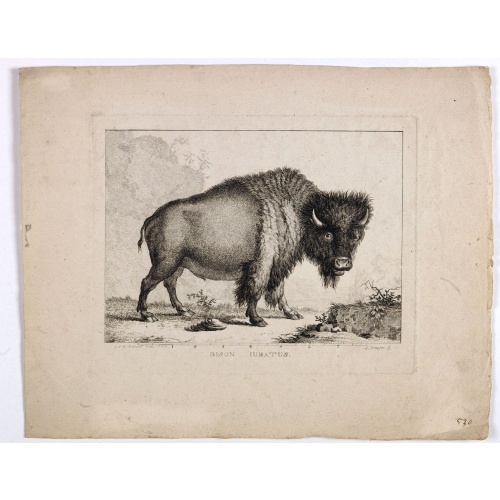
Bison Iubatus.
Etching of a bison by Leendert Brasser (1727 - 1793) after a painting of the Dutch artist Gerrit van den Heuvel.An early portrait of a bison, etched by Leendert Brasser (1727-93) after Gerrit van den Heuvel.Gerrit van den Heuvel portraited this bison in 1766 in the menagerie of Arnout Vosmaer (1720 - 1799). Vosmaer was a Dutch naturalist and collection curator. In 1756 Vosmaer became the director of a natural history collection started by Princess Anna, the wife of William IV, Prince of Orange a...
€750
Maker : BRASSIER, L
Place : Rotterdam
Date : 1766-1793
![A Map of the United States and Canada, New-Scotland, New-Brunswick and New-Foundland ... [together with] A Map of the West-Indies and of the Mexican-Gulph...](/uploads/cache/39235-500x500.jpg)
A Map of the United States and Canada, New-Scotland, New-Brunswick and New-Foundland ... [together with] A Map of the West-Indies and of the Mexican-Gulph...
A Map of the United States and Canada, New-Scotland, New-Brunswick and New-Foundland / Carte des Etats Unis, avec Le Canada, la Nouvelle Ecosse, le Nouveau Brunswick & Terre-Neuve. Dressée par LAPIE, Capitaine-Ingénieur-Géographe. Publiée par P.A.F.TARDIEU, Graveur, Editeur propriétaire a Paris. Déposée à la Bibliothèque Imperiale, le 10 Juin 1806. [together with]A Map of the West-Indies and of the Mexican-Gulph / Carte des Indes Occidentales et du Golfe du Mexique. Dressée par LAPIE, ...
€5.000
Maker : P.A.F. TARDIEU
Place : Paris
Date : 1806
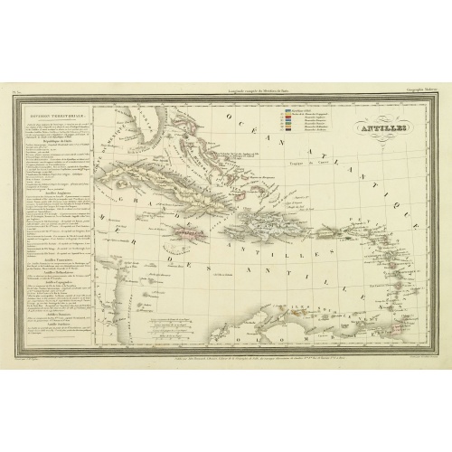
Antilles.
Finely engraved map of the Caribbean, with a color key to Spanish, English, French, Danish, Dutch and Swedish possessions, prepared by A.H.Dufour and engraved by Giraldon-Bovinet. Published by Jules Renouard in his uncommon atlas "Le globe Atlas classique Universel de géographie ancienne et moderne, pour servir a l'étude de la géographie et de l'histoire dressé par M. A.H.Dufour, Et revu par M.Jomard".To the left- "Tableau statistique", giving details on geographical, statistical and economi...
€75
Maker : DUFOUR, A.H.
Place : Paris, Jules Renouard
Date : ca. 1840
Etats-Unis de l'Amérique du nord.
Detailed map of North America, prepared by Charles V. Monin (fl.1830-1880) a French cartographer of Caen and Paris. Published in Atlas Universel de Géographie Ancienne &c Moderne en 42 Cartes dressé par C.V. Monin. Engraved by Laguillermie.
€75
Maker : MONIN, C.V.
Place : Paris
Date : 1845

West India Islands.
Map of the West Indies, published by "The London Printing and Publishing Company". Drawn and engraved by John Rapkin.
€75
Maker : RAPKIN, J.
Place : London
Date : 1854
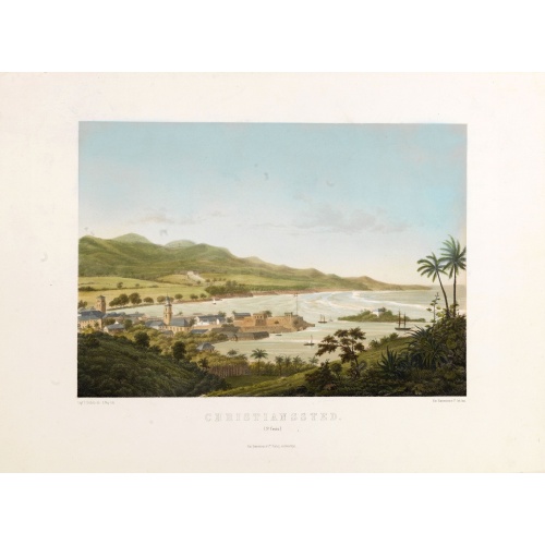
Christianssted. (St.Croix).
A beautiful view of the small town of Christiansted on the island of St. Croix. This view shows much of the harbour and a portion of the town's waterfront. one of a series of six lithographs of St. Thomas produced by the publishing firm of Baerentzen & Co. Drawn on stone by E. Westerberg after a drawing by Capt. P. Seidelin.
€900
Maker : BAERENTZEN CO.
Place : Copenhagen, Baerentzen & Co.
Date : 1856
-500x500.jpg)
Nuovo Mondo parte Settentrionale.
Uncommon map of North America prepared by Francesco Costantino Marmocchi. Above the map "Geografia Commerciale". From "Il Globo Atlante di carte Geografiche compilate da F.C. Marmocchi per servire di corredo al suu corso di geografia commerciale", with the maps engraved by engraved by Gius. Cattaneo, Campo Antico, C. Poggiali, G. Bonatti, and Ces. Magrini.Marmocchi (Poggibonsi, 1805-Geneva, 1858) was known as a geographer and cartographer. He emigrated to Rome, and later to Corsica, later settle...
€50
Maker : MARMOCCHI, F.C.
Place : Genova, Paolo Rivara fu Giacomo
Date : 1858
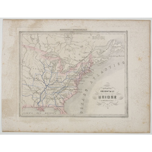
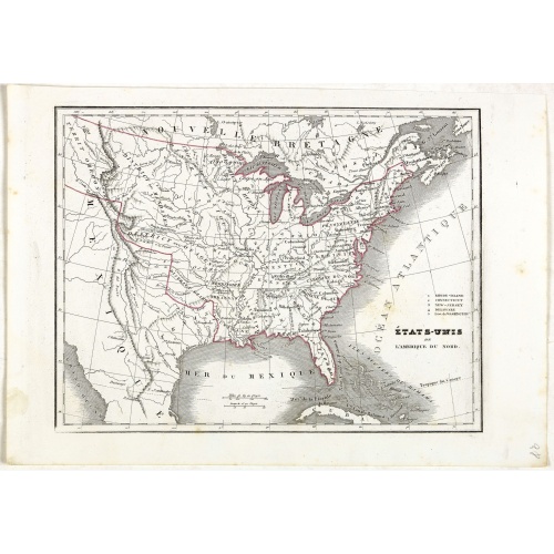
Stati Orientali della Unione Americana.
Uncommon map of Northeastern America prepared by Francesco Costantino Marmocchi. Above the map "Geografia Commerciale". From "Il Globo Atlante di carte Geografiche compilate da F.C. Marmocchi per servire di corredo al suu corso di geografia commerciale", with the maps engraved by engraved by Gius. Cattaneo, Campo Antico, C. Poggiali, G. Bonatti, and Ces. Magrini.Marmocchi (Poggibonsi, 1805-Geneva, 1858) was known as a geographer and cartographer. He emigrated to Rome, and later to Corsica, later...
€50
Maker : MARMOCCHI, F.C.
Place : Genova, Paolo Rivara fu Giacomo
Date : 1858
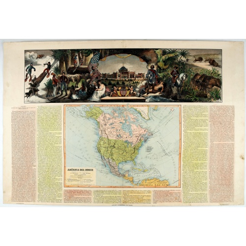
América del Norte.
Very attractive large map of North America with stunning panorama at top of figures representing the continents, etc. A rare and decorative map. From "Atlas geográfico universal texto redactado bajo la dirección de Dr. D. Juan Vilanova parte artística bajo la dirección de Otto Neussel Dibº geogrº J.P. Morales, cromo litogrº Ginés Ruiz".Good hand color on panorama and original lithographic color on the map. The most ambitious of all the monographs and scientific works by Spanish geographe...
€550
Maker : ASTORT HERMANOS EDITORES
Place : Madrid
Date : 1877