

Nieuwe Paskaert van de Kust van HOLLANDT - Tussen Texel en de Maes.
Nieuwe Paskaert van de Kust van Hollandt Tussen Texel en de Maes. A very attractive sea chart off the coast of Holland by Johannes van Keulen with a pair of decorative cartouches, ships sailing off the coast, rhumb lines, compass rose etc. Van Keulen was the founder of the successful van Keulen firm that published charts, pilot guides and sea-atlases for over 2 centuries. In 1680, he published his immensely popular 'Zee Atlas ofte Water Werelt'.
€500
Maker : van Keulen, J.
Place : Amsterdam
Date : ca 1685
Hydrograhica descriptio
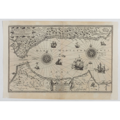
This very rare chart is important as the first printed sea chart of the Mediterranean coast of Spain, Gibraltar, also depicting the northern coast of Marocco.Willem Barentsz (1560-1597) was a famous pilot, discoverer and cartographer. Author of 'Nieuwe Beschrhryvinghe ende caertboeck van de Midlantsche Zee', the first printed pilot-guide of the Mediterranean. It is considered the supplement of Waghenaer's 'Spieghel der Zeevaerdt' for the Mediterranean waters.
€4.000
Maker : BARENDTSZ, W.
Place : Amsterdam, W. Blaeu
Date : 1612
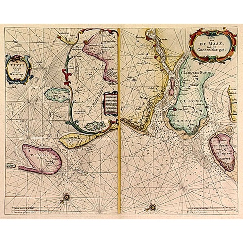
De Texel Stroom .. vant Marsdiep./ Caarte van De Mase...
Two decorative charts on one sheet, one depicting Texel and the entrance of the Zuider Zee with an inset showing the north coast of West-Friesland, the other depicting the river Maas as far inland as Rotterdam and the islands of South Holland.
$600
Maker : GOOS, P.
Place : Amsterdam
Date : 1660
-500x500.jpg)
Osservazioni meteorologiche e punti neri all'orizzonte
Osservazioni meteorologiche e punti neri all'orizzonte
€450
Maker : Gioannetti Leonida diresse
Place : Italy
Date : 1896
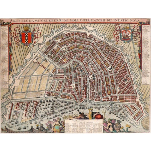
Leti, Amsterdam
54x42,5 cm. Amstelodami Celeberrimi Hollandiae emporii Delineato Nova. Colored Copper engraving. G. Leti. Amsterdam 1690
€2.250
Maker : LETI, G.
Place : Amsterdam
Date : 1690

Kaart van de Reede van Batavia met de verschillende vaarwaters naar dezelve trigometrisch opgenomen op last van deb schout bijnacht E.Lucas.
Very large and rare so-called blue-black chart centered on Jakarta's harbor.The chart is prepared by B.G.Escher, I.A.C. Eschauzier, B.H.Staring and E.H.Boom during an expedition in 1841 by the ships Krokodil and Hekla. The chart is engraved by J.C.Zurcher and updated for and published in 1847 by Jacob Swart. When Gerard Hulst van Keulen died in 1801, his widow ran the firm until her death in 1810, at which time Johannes Hulst van Keulen became the last van Keulen to run the firm.In 1823, Jacob S...
$1.800
Maker : HULST VAN KEULEN, Wed. G.
Place : Amsterdam
Date : (1841) 1847

De zee cuften tufschen Dovere en Orfords nesse, daer de Teemse de Vermaerde Rivire van Lonen gelegens is. . .
A detailed chart of the English Channel coastland. Decorated by a colorful title cartouche and scale cartouche, one compass rose, several vessels and sea monsters. A very early edition rare Dutch text edition of this landmark contribution to the science of navigation. Waghenaer's own personal experiences as a pilot along European coasts were used to compile the Spiegel der Zeevaerdt, the first edition of which was published in Dutch at Leyden in 1584/85 by the House of Plantin. Although advertis...
$3.000
Maker : WAGHENAER, L. J.
Place : Leiden, Plantijn
Date : 1585
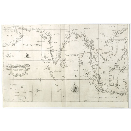
Carta prima Generale dell' Asia.
FIRST STATE of Robert Dudley's general chart of the Persian Gulf, going east through India to the southeastern coast of China showing Macau and the area of present-day Hong Kong. The map goes south through the Philippines, passing through Borneo, the western part of Celebes (now Sulawesi, Indonesia). It also includes the Maldives and the Chagos Archipelago.This elegant sea chart is crisply engraved in the sparse Florentine style with superb calligraphy throughout. Very decorative chart from the ...
$17.500
Maker : DUDLEY, R.
Place : Florence
Date : 1646
![[Printed on silk] Nieuw Wassende Graaden Paskaart Vertoonende alle de bekende Zeekusten en Landen op den geheelen Aard Boodem of Werelt door Gerard van Keulen. . .](/uploads/cache/31640-500x500.jpg)
[Printed on silk] Nieuw Wassende Graaden Paskaart Vertoonende alle de bekende Zeekusten en Landen op den geheelen Aard Boodem of Werelt door Gerard van Keulen. . .
A very scarce and beautiful chart on Mercator's projection printed on silk. The map is printed on silk. With the name of Gerard van Keulen and the privilege. The map shows great interior detail, including a well-formed depiction of the Great Lakes and Mississippi River. Fort de Creveceur is shown near the Illinois River. The east coast of Siberia has been drawn after Nicolas Witsen's 1687 map of Tartary. A Great Companies Land has been added off the northwest coast of America. California is an i...
$20.000
Maker : VAN KEULEN, G.
Place : Amsterdam
Date : 1728
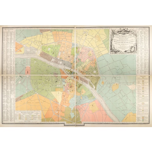
Plan des paroisses de Paris avec la distinction des parties éparses qui en dépendent dressé... par J. Junié, Ingén. Géogr. De Monseigneur l'Archeveque et géomètre des Eaux et forêts de ...
Large wall map size plan of Paris in 4 separate sheets, if joined forming a plan of Paris of 93 x 60cm. This plan is a 1904 version of a manuscript plan drawn in 1786 by Junié for A.-L. Le Clerc de Juigné.Published by Service des Travaux historiques de la Ville de Paris. To the left and right, a lettered key with a list of parishes with their boundaries and legends.Top right, title in an ornate cartouche: two women, symbolizing piety and justice, around the arms of LeClerc de Juigné (1728-1...
€750
Maker : JUNIÉ, J.
Place : Service des Travaux historiques de la Ville de Paris
Date : 1904

Europa recens descripta à Guilielmo Blaeuw.
On either side columns depicting the manner of dress in the major countries of Europe, surmounted by nine city views and plans.For European mapmakers their own continent contained few mysteries or secrets by the seventeenth century. However, the mythical island of Frisland still appears between Iceland and Greenland. The map is decorated with ships and a sea monster on the sea, bears on northern Russia, and lions on North Africa.
€3.250
Maker : BLAEU, W.
Place : Amsterdam
Date : 1644
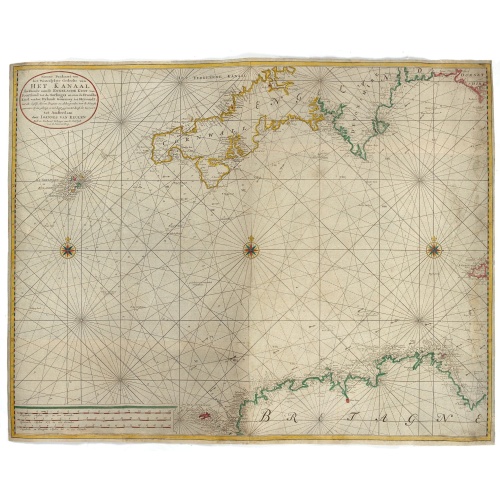
Nieuwe Paskaart van het Westerlykste Gedeelte van HET KANAAL strekkende aan de ENGELSCHE KUST van Poortland tot de Sorlinges. . .
Nieuwe Paskaart van het Westerlykste Gedeelte van HET KANAAL strekkende aan de ENGELSCHE KUST van Poortland tot de Sorlinges en aan de Fransche kust van het Eylandt Guernsey tot Heysandt. Ioannes van Keulen A RARE and decorative chart of the Channel between England and France. Decorated with a fine title cartouche: Nieuwe Paskaart van het Westerlykste Gedeelte van HET KANAAL strekkende aan de ENGELSCHE KUST van Poortland tot de Sorlinges en aan de Fransche Kust van het Eylandt Guernsey tot He...
€900
Maker : VAN KEULEN, J.
Place : Amsterdam
Date : 1760

(Sea-chart of Catalunia, Languedoc, Provence, Cote d'Azur, Riviera, Corsica with Marseille, Cannes, Nice, Monaco.)
This very rare chart is important as the first printed sea chart of France's Mediterranean coast, also depicting Catalunya's northern coast, the Italian Cote d'Azur till San Remo and Corsica's west coast.Willem Barentsz (1560-1597) was a famous pilot, discoverer and cartographer. Author of 'Nieuwe Beschrhryvinghe ende caertboeck van de Midlantsche Zee', the first printed pilot-guide of the Mediterranean. It is considered the supplement of Waghenaer's 'Spieghel der Zeevaerdt' for the Mediterranea...
€4.000
Maker : BARENTSZ, Willem.
Place : Amsterdam
Date : 1607

Beschrijvinge vande de zee Cuften va Vlanderen en Picardien. . .
DUTCH TEXT EDITION. A detailed chart of the coast of Flanders and Normandy decorated by a large colorful baroque title cartouche, and the coat of arms of Flanders with a colorful scale cartouche decorated with a compass, a compass rose, several vessels and sea monsters. From an early Dutch text edition of this landmark contribution to the science of navigation. Waghenaer's own personal experiences as a pilot along European coasts were used to compile the Spiegel der Zeevaerdt, the first edition ...
$3.000
Maker : WAGHENAER, L. J.
Place : Leiden, Plantijn
Date : 1585

Belchrijuinghe vande zee custen van Engelandt. . .
A rare Dutch text edition of this detailed early chart of the northern coast of England. West to the top. The mileage cartouche has no Latin captures. Decorated by a colorful title cartouche and scale cartouche, one compass rose, and several vessels. An early Dutch text edition of this landmark contribution to the science of navigation. Waghenaer's own experiences as a pilot along European coasts were used to compile the Spiegel der Zeevaerdt, the first edition of which was published in Dutch at...
$3.000
Maker : WAGHENAER, L. J.
Place : Leiden, Plantijn
Date : 1585

Straat Riouw onder opzicht van de commissie tot verbetering der Indische Zeekaarten..
Very large and rare so-called Blue Back chart centered on the strait passing between the Riau Islands. It contains an inset map with enlarged details of Riouw Harbor on Bintang Island.Coastal profiles are shown in the lower-left corner of the chart.The chart is prepared by W.H.Dittlof Tjassens, P.A.J.Bloijs van Treslong Prins and J.van Gogh during an expedition in 1840 by the ship Nehalennia under the command of Captain F.G.van der Plaat. The chart is engraved by D.Veelwaard Jr. And published in...
$1.250
Maker : HULST VAN KEULEN, Wed.G.
Place : Amsterdam
Date : 1843

Pas-Kaat vaneen gedeelte van de Aethiopische Zee behelsende de Kusten Zanguebar, Ajan en Abex, en een gedeelte van de Arabische Kust. . .
A finely engraved and detailed chart of the most eastern tip of Africa, including Somalia, Djibouti, Yemen, Mauritius, and many other islands in the Indian Ocean.Very rare: only included in 6th volume (so-called secret atlas) of Van Keulen's. Latitude scale, compass rose and system of rhumb lines, soundings, anchorage's, etc. Many Dutch names and a wealth of cities and information appear in the chart. The trading posts of the different nations are marked with flags. Number 47. in lower left corn...
$4.500
Maker : VAN KEULEN, J.
Place : Amsterdam
Date : 1753

Mappe-Monde pour connoitre les progres & les conquestes..
Unusual double hemisphere map with California as an Island. Dutch text describes the expeditions and colonial possessions of the Dutch East India Company. The map originated in about 1670. Chatelain acquired the plate; he added decorative elements, including sailing ships, the Dutch crest, and a figure representing Europa seated inside a native fort.Zacharie Chatelain (d.1723) was the father of Henri Abraham (1684-1743) and Zacharie Junior (1690-1754).They worked as a partnership publishing the ...
$800
Maker : CHATELAIN, H.
Place : Amsterdam
Date : 1729
-500x500.jpg)
Kaart van de Gaspar Straaten volgens opnemingen van J.Stolze, D.Ross, enz.
Very large and rare chart centered on the strait between Bangka's southeastern seacoast and Belitung's western shores.Short front views of the coastal relief are shown in the lower-left corner of the map.The chart is prepared by H.L.Osthoff in 1840 and published in 1844 by Jacob Swart. When Gerard Hulst van Keulen died in 1801, his widow ran the firm until her death in 1810, at which time Johannes Hulst van Keulen became the last van Keulen to run the firm.In 1823, Jacob Swart entered the servic...
$900
Maker : HULST VAN KEULEN, Wed.G.
Place : Amsterdam
Date : 1843
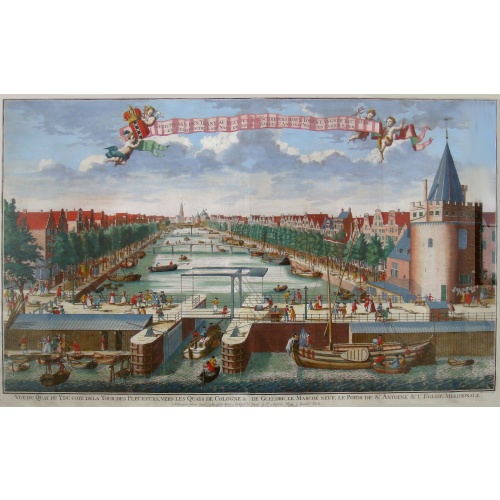
Beschrijving Gezicht van den Ykant af bezyden den Schreiers hoex Toren langs de Keulsche en Geldersche Kaei naer de Nieuwe Markt
This large engraving (560x920mm.) comes from a are series of 25 beautiful large views of Amsterdam and gives a colorful picture of the life and business of the city at the beginning of the 18th century. The print gives a view of the cityscape and architecture of that time. It also shows daily manners and customs and all kinds of scenes take place; There is a fight to the left of the bridge in the foreground (now Prins Hendrik Kade), while in front of the Scheierstoren quiet citizens read the not...
$2.000
Maker : DE LETH, H.
Place : Amsterdam
Date : ca 1720