
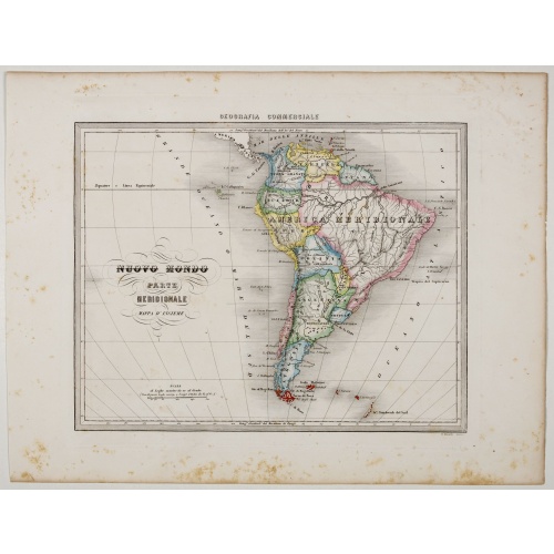
Nuovo Mondo parte Meridionale.
Uncommon map of South America prepared by Francesco Costantino Marmocchi. Above the map "Geografia Commerciale". From "Il Globo Atlante di carte Geografiche compilate da F.C. Marmocchi per servire di corredo al suu corso di geografia commerciale", with the maps engraved by engraved by Gius. Cattaneo, Campo Antico, C. Poggiali, G. Bonatti, and Ces. Magrini.Marmocchi (Poggibonsi, 1805-Geneva, 1858) was known as a geographer and cartographer. He emigrated to Rome, and later to Corsica, later settle...
€75
Maker : MARMOCCHI, F.C.
Place : Genova, Paolo Rivara fu Giacomo
Date : 1858
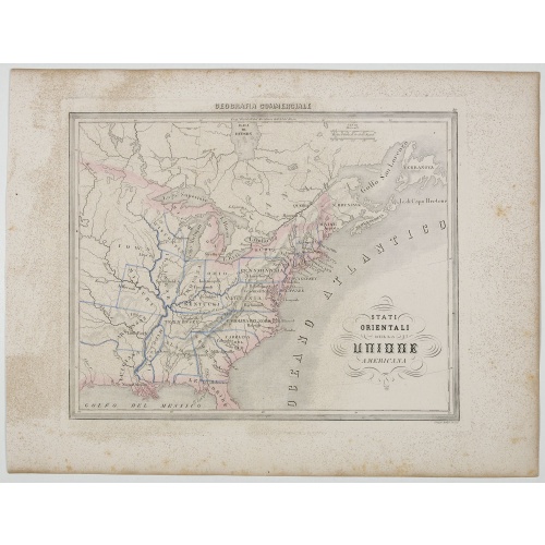
Stati Orientali della Unione Americana.
Uncommon map of Northeastern America prepared by Francesco Costantino Marmocchi. Above the map "Geografia Commerciale". From "Il Globo Atlante di carte Geografiche compilate da F.C. Marmocchi per servire di corredo al suu corso di geografia commerciale", with the maps engraved by engraved by Gius. Cattaneo, Campo Antico, C. Poggiali, G. Bonatti, and Ces. Magrini.Marmocchi (Poggibonsi, 1805-Geneva, 1858) was known as a geographer and cartographer. He emigrated to Rome, and later to Corsica, later...
€50
Maker : MARMOCCHI, F.C.
Place : Genova, Paolo Rivara fu Giacomo
Date : 1858
-500x500.jpg)
Nuovo Mondo parte Settentrionale.
Uncommon map of North America prepared by Francesco Costantino Marmocchi. Above the map "Geografia Commerciale". From "Il Globo Atlante di carte Geografiche compilate da F.C. Marmocchi per servire di corredo al suu corso di geografia commerciale", with the maps engraved by engraved by Gius. Cattaneo, Campo Antico, C. Poggiali, G. Bonatti, and Ces. Magrini.Marmocchi (Poggibonsi, 1805-Geneva, 1858) was known as a geographer and cartographer. He emigrated to Rome, and later to Corsica, later settle...
€50
Maker : MARMOCCHI, F.C.
Place : Genova, Paolo Rivara fu Giacomo
Date : 1858
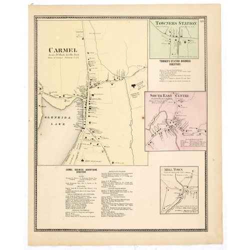
Town of Carmel / Towners Station / South East Centre / Mill Town.
Fine lithographed map of the town of Carmel / Towners Station / South East Centre / Mill Town. From "Atlas of New York and vicinity" published by Beers, Ellis & Soule, 95 Maiden Lane, New York.The map provides the names of specific homeowners, as well as information about the occupations and physical locations of the various tradesmen in each village from Beer's famous county atlas "Atlas of New York and vicinity," "a documentary record of nineteenth-century life and delightful specimens of Ame...
€80
Maker : DE BEERS, F. W.
Place : New York
Date : 1867
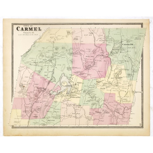
Town of Carmel.
Fine lithographed map of the town of Carmel. From : "Atlas of New York and vicinity" published by Beers, Ellis & Soule, 95 Maiden Lane, New York. The map provides the names of specific homeowners, as well as information about the occupations and physical locations of the various tradesmen in each village from Beer's famous county atlas "Atlas of New York and vicinity," "a documentary record of nineteenth-century life and delightful specimens of American folk art." F. W. Beers, along with other ...
€80
Maker : DE BEERS, F.W.
Place : New York
Date : 1867
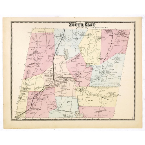
Town of South East.
Fine lithographed map of the town of South East. From : "Atlas of New York and vicinity" published by Beers, Ellis & Soule, 95 Maiden Lane, New York.The map provides the names of specific homeowners, as well as information about the occupations and physical locations of the various tradesmen in each village from Beer's famous county atlas "Atlas of New York and vicinity, a documentary record of nineteenth-century life and delightful specimens of American folk art."F. W. Beers, along with other m...
€90
Maker : DE BEERS, F.W.
Place : New York, 1867
Date : 1867
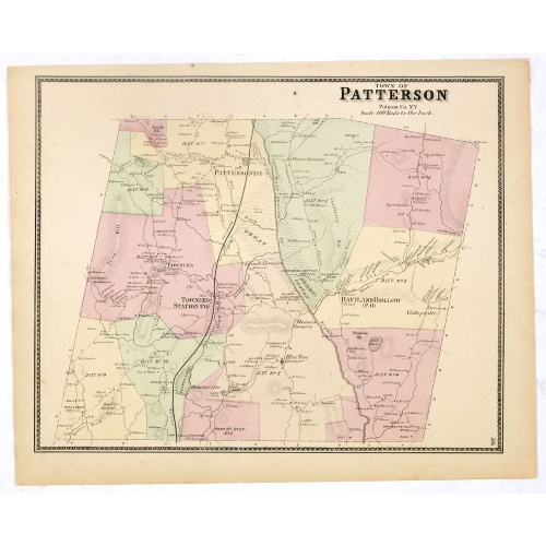
Town of Patterson.
Fine lithographed map of the town of Patterson. From : "Atlas of New York and vicinity" published by Beers, Ellis & Soule, 95 Maiden Lane, New York.The map provides the names of specific homeowners, as well as information about the occupations and physical locations of the various tradesmen in each village from Beer's famous county atlas "Atlas of New York and vicinity," "a documentary record of nineteenth-century life and delightful specimens of American folk art." F. W. Beers, along with othe...
€90
Maker : DE BEERS, F.W.
Place : New York
Date : 1867
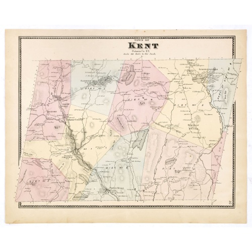
Town of Kent.
Fine lithographed map of the town of Kent. From :"Atlas of New York and vicinity" published by Beers, Ellis & Soule, 95 Maiden Lane, New York.The map provides the names of specific homeowners, as well as information about the occupations and physical locations of the various tradesmen in each village from Beer's famous county atlas "Atlas of New York and vicinity", a documentary record of nineteenth-century life and delightful specimens of American folk art.F. W. Beers, along with other members ...
€90
Maker : DE BEERS, F. W.
Place : New York
Date : 1867
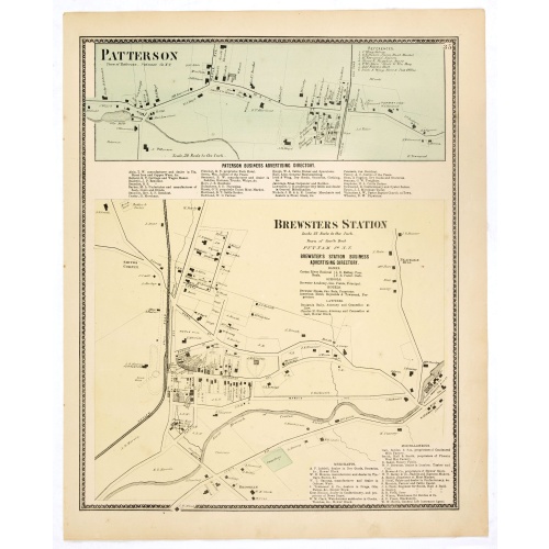
Town of Patterson / Brewsters Station.
Fine lithographed map of the town of Patterson / Brewsters Station. From : "Atlas of New York and vicinity" published by Beers, Ellis & Soule, 95 Maiden Lane, New York. The map provides the names of specific homeowners, as well as information about the occupations and physical locations of the various tradesmen in each village from Beer's famous county atlas "Atlas of New York and vicinity, a documentary record of nineteenth-century life and delightful specimens of American folk art." F. W. Beer...
€80
Maker : DE BEERS, F. W.
Place : New York
Date : 1867
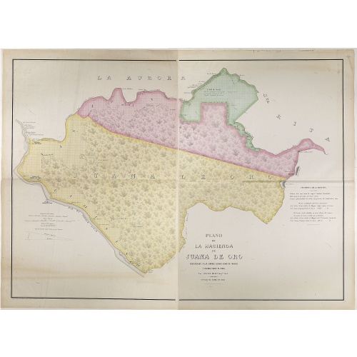
Plano de la Hacienda de Juana de Oro.
Wall-map sized map in 2 sheets, if joined 940 x 1300mm., showing the Hacienda (farm) of Juana de Oro in Ecuador. The cocoa farm was owned by Mrs. Leonor Carbo of Higgins and Virginia Carbo of Icaza. Cocoa plantations are depicted on the map by a multitude of shrubs. This plan provides information on cocoa productivity and distribution among the owners.
€750
Maker : DILLON, A.
Place : Guayaquil ( Equateur)
Date : 1868
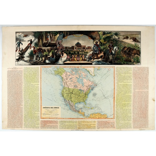
América del Norte.
Very attractive large map of North America with stunning panorama at top of figures representing the continents, etc. A rare and decorative map. From "Atlas geográfico universal texto redactado bajo la dirección de Dr. D. Juan Vilanova parte artística bajo la dirección de Otto Neussel Dibº geogrº J.P. Morales, cromo litogrº Ginés Ruiz".Good hand color on panorama and original lithographic color on the map. The most ambitious of all the monographs and scientific works by Spanish geographe...
€550
Maker : ASTORT HERMANOS EDITORES
Place : Madrid
Date : 1877
![[Map of the Monterey Peninsula.]](/uploads/cache/48349-500x500.jpg)
[Map of the Monterey Peninsula.]
A lovely example of Jo Mora's Del Monte Properties Company' California's Fun' playground tourist map of the Monterey Peninsular, published in San Francisco in 1927. The rare first state and among the rarest maps by Jo Mora.A lively map full of interesting, fun illustrations of the region. The map borders are surrounded by many small illustrations of modern and historical Monterey. These include animals, historical figures, native Indians, missionaries, cowboys, singing & dancing, the 'gold rush'...
€900
Maker : ROBERTSON, A.M.
Place : San Francisco
Date : 1927

Map of Atlantic City to Hackney's Famous Garden of Sea Food . . .
A mid 1950s brochure for the famous Atlantic City Seafood Restaurant - 'Hackneys'. One side proclaims that "All Roads lead to Hackney's". It shows a nice plan of Atlantic City in NJ. Highlighted in red are the famous Boardwalk, Pacific, Atlantic, Albany and Mediterranean Avenues plus Absecon Boulevard, and all roads that lead off them.Other major thoroughfares and roads are shown, together with the Airport and bus and car route. Famous piers are in bold, plus there are small illustrations of sea...
€50
Maker : ANONYMOUS.
Place : New Jersey
Date : 1954