
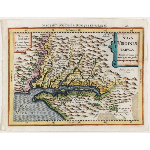
Virginiae item et Floridae . . .
Map of Virginia from the rare Cloppenburg edition slightly larger format and more scarce edition of the Mercator/Hondius "Atlas Minor". Engraved by Pieter Van Den Keere.The Cloppenburg edition "Atlas Sive Cosmographicae Meditationes De Fabrica Mundi Et Fabricati Figura", was continued for a couple of years but seems to have been suppressed after 1636 ... (Koeman Atlantes Neerlandici).Based on the 1595 Abraham Ortelius map, but with added decoration.
€750
Maker : MERCATOR, G. / CLOPPENBURGH, J.E.
Place : Amsterdam
Date : 1630
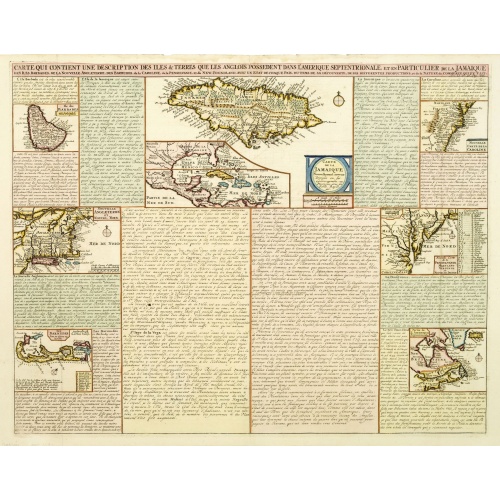
Carte qui contient..Iles & Terres..L'Amerique..Jamaique..
Eight maps on one sheet. From Chatelain's Atlas Historique et Méthodique . Including maps of Bermuda, Jamaica, New England with Long Island, Carolina, Chesapeake and Delaware Bay, Nova Scotia and a map of the Caribbean.
€500
Maker : CHATELAIN, H.
Place : Amsterdam
Date : 1728
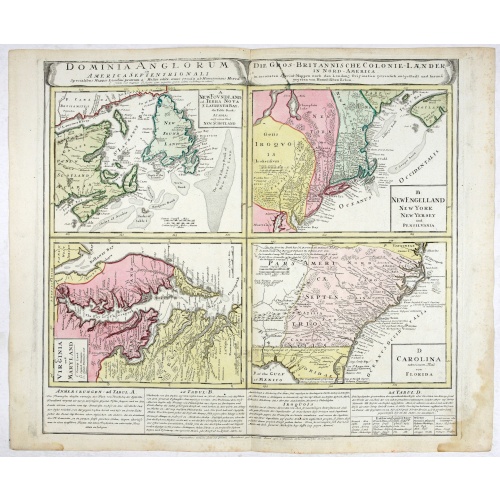
Dominia Anglorum in America Septentrionali.
Four maps on one sheet (New Found land/ New England/ Virginia and Carolina/Florida) based on J.B.Homann's map, showing British possessions in North America. The upper left shows territory in Newfoundland and around the Bay of St. Lawrence, with portions of the ‘lost’ colony of New Scotland. The Grand Banks are prominently noted as well. The map immediately to the right shows claims in New York and New England, with large areas in Pennsylvania noted as belonging to the Iroquois. The lower lef...
€750
Maker : HOMANN HEIRS.
Place : Nuremberg 1740
Date : 1740
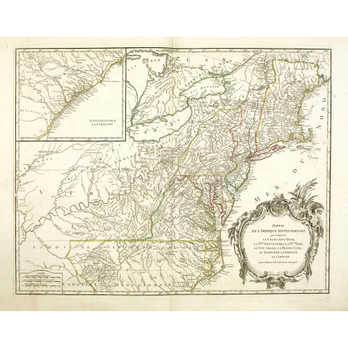
Partie De L'Amerique Septentrionale... Le Cours De L'Ohio, La N.lle Angleterre, a Nlle York, le New Jersey , La Pensyvanie, Le Maryland, Le Virginie, La Carolina...1755
From the Atlas Universel , a detailed map extending the length of the east coast from Penobscot Bay to Cape Fear and, in an inset, from Cape Fear to Fort St.Georges.This state with a dotted border of Treaty of Paris, 1763, with Virginie and Caroline Sept. Et Merid. Extended west to Mississippi. New-Hemp-Shire" and Prov. De Sagadahock" now added.The Atlas Universel of Gilles and Didier Robert de Vaugondy was first published in 1755. The maps were detailed, precisely engraved and not given to the ...
€800
Maker : DE VAUGONDY, R. de
Place : Paris
Date : 1768

Mappa geographica Provinciæ Nova Eboraci ab Anglis New-York . . .
Lower part of the two sheets map of Homann Heirs' edition of Sauthier's celebrated map of New York and New Jersey, made during the Revolutionary War. Appears in Homann's Atlas geographicvs maior. 1759-[1784].
€750
Maker : HOMANN HEIRS.
Place : Nuremburg
Date : 1778
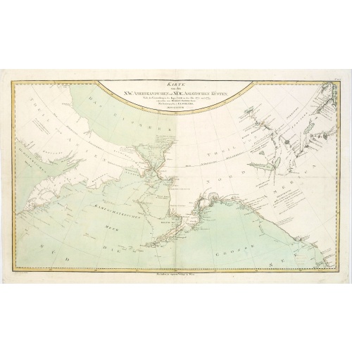
Karte von den N.W. Amerikanischen und N.OE. Asiatischen Kusten nach den Untersuchungen des Kapit. Cook...
A detailed large-scale map showing the Bering Strait, Kamchatka, Alaska and much of North America. While the Russian coastline is shown with reasonable accuracy. Showing tracks of Captain Cook. Prepared by Heinrich Roberts.A German language variant of Cook’s map of his explorations along the northwest coast of America and the northeast coast of Asia. Based upon original work by Cook’s cartographer Henry Roberts. Vancouver Island is missing. Shows several lakes west of Hudson Bay in what is...
€900
Maker : SCHRAEMBL, F.A.
Place : Vienna
Date : 1788

Die Vereinigten Staaten von Nord Amerika..
Uncommon map of the east coast of North America, including the Great Lakes area. To the right inset map of New Foundland. After the map by William Faden of 1783. With color-key.
€500
Maker : MARIANUS, J.
Place : Germany, 1790
Date : 1790

Plan du Port des Francais sur la Cote du Nord-Ouest de l'Amerique, par 58°37' de Latitude Nord et 139°50' de Longitude Occidentale, Decouverte le 2 Juillet 1786,...
Chart of the entrance of Bassin de L'Quest , visited on July 2nd 1786 by La Perouse. On many 18th century maps we find a depiction of Mer de L'Quest or Sea of the West a great sea, easily the size of the Mediterranean, to flow from the then-known Strait of Juan de Fuca and an opening to the ocean from this great sea at roughly in North California or Oregon and Quivira somewhere in Idaho.Engraved by Bouclet.
€500
Maker : LA PEROUSE, J.F.G.
Place : Paris
Date : 1798
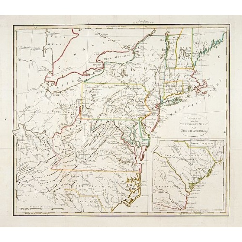
Gedeelte van den Vereenigden Staat van Noord Amerika.
A rare an detailed map of the eastern part of the United States of America. After Isaac Weld's map from his Travels through the States of North America 1799. Barbara Backus McCorkle does mention English, French and German editions, but not this Dutch text edition. (See map 800.4 for a German text variant)Lower right hand corner inset map of South Carolina.
€750
Maker : ANONYMOUS
Place : Netherlands c. 1820
Date : 1820
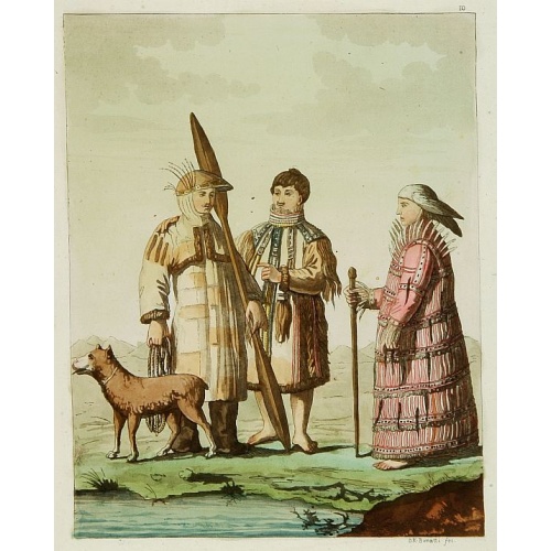
Les Aleuts.
From Giulio Ferrario's work Le Costume ancien et moderne ou histoire du gouvernement, de la milice, de la religion, des arts, etc. published in Milan by the author between 1816 and 1827.This aquatint engraved plate was color printed on fine wove paper of a soft aged white color, bearing the embossed seal of authenticity impressed at the time of publication with the legend "Il Costume Antico E Moderno" surrounding the initials GF. A beautifully hand colored aquatint with additional hand-coloring....
€50
Maker : FERRARIO, G.
Place : Milan
Date : 1827
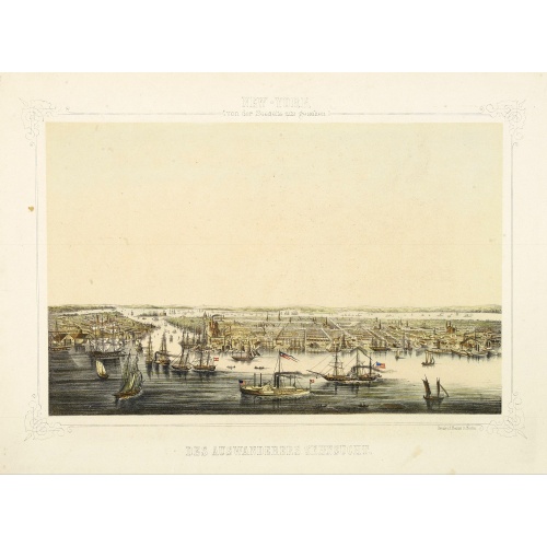
New York von der Seeseite aus gesehen.
Very decorate view of New-York. J.Hesse was known as a portrait painter and publisher of lithographs. A long panorama of the shoreline from the sea, with sailing vessels and American steamships in the busy port.
€700
Maker : HESSE, J.
Place : Berlin
Date : c. 1850
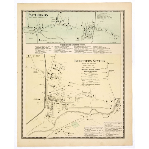
Town of Patterson / Brewsters Station.
Fine lithographed map of the town of Patterson / Brewsters Station. From : "Atlas of New York and vicinity" published by Beers, Ellis & Soule, 95 Maiden Lane, New York. The map provides the names of specific homeowners, as well as information about the occupations and physical locations of the various tradesmen in each village from Beer's famous county atlas "Atlas of New York and vicinity, a documentary record of nineteenth-century life and delightful specimens of American folk art." F. W. Beer...
€80
Maker : DE BEERS, F. W.
Place : New York
Date : 1867
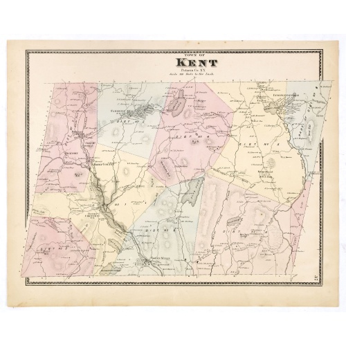
Town of Kent.
Fine lithographed map of the town of Kent. From :"Atlas of New York and vicinity" published by Beers, Ellis & Soule, 95 Maiden Lane, New York.The map provides the names of specific homeowners, as well as information about the occupations and physical locations of the various tradesmen in each village from Beer's famous county atlas "Atlas of New York and vicinity", a documentary record of nineteenth-century life and delightful specimens of American folk art.F. W. Beers, along with other members ...
€90
Maker : DE BEERS, F. W.
Place : New York
Date : 1867
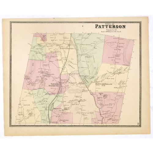
Town of Patterson.
Fine lithographed map of the town of Patterson. From : "Atlas of New York and vicinity" published by Beers, Ellis & Soule, 95 Maiden Lane, New York.The map provides the names of specific homeowners, as well as information about the occupations and physical locations of the various tradesmen in each village from Beer's famous county atlas "Atlas of New York and vicinity," "a documentary record of nineteenth-century life and delightful specimens of American folk art." F. W. Beers, along with othe...
€90
Maker : DE BEERS, F.W.
Place : New York
Date : 1867
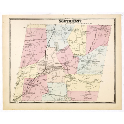
Town of South East.
Fine lithographed map of the town of South East. From : "Atlas of New York and vicinity" published by Beers, Ellis & Soule, 95 Maiden Lane, New York.The map provides the names of specific homeowners, as well as information about the occupations and physical locations of the various tradesmen in each village from Beer's famous county atlas "Atlas of New York and vicinity, a documentary record of nineteenth-century life and delightful specimens of American folk art."F. W. Beers, along with other m...
€90
Maker : DE BEERS, F.W.
Place : New York, 1867
Date : 1867
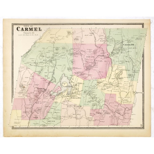
Town of Carmel.
Fine lithographed map of the town of Carmel. From : "Atlas of New York and vicinity" published by Beers, Ellis & Soule, 95 Maiden Lane, New York. The map provides the names of specific homeowners, as well as information about the occupations and physical locations of the various tradesmen in each village from Beer's famous county atlas "Atlas of New York and vicinity," "a documentary record of nineteenth-century life and delightful specimens of American folk art." F. W. Beers, along with other ...
€80
Maker : DE BEERS, F.W.
Place : New York
Date : 1867
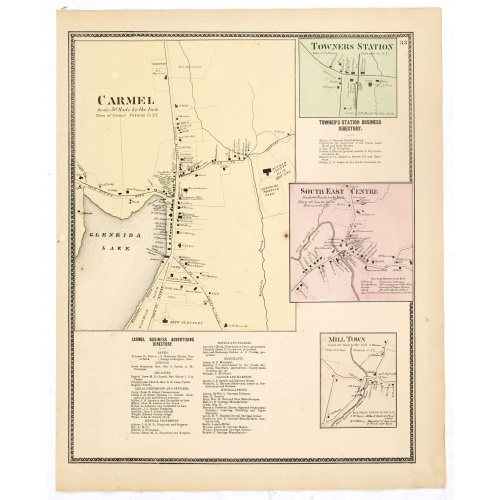
Town of Carmel / Towners Station / South East Centre / Mill Town.
Fine lithographed map of the town of Carmel / Towners Station / South East Centre / Mill Town. From "Atlas of New York and vicinity" published by Beers, Ellis & Soule, 95 Maiden Lane, New York.The map provides the names of specific homeowners, as well as information about the occupations and physical locations of the various tradesmen in each village from Beer's famous county atlas "Atlas of New York and vicinity," "a documentary record of nineteenth-century life and delightful specimens of Ame...
€80
Maker : DE BEERS, F. W.
Place : New York
Date : 1867
![[Map of the Monterey Peninsula.]](/uploads/cache/48349-500x500.jpg)
[Map of the Monterey Peninsula.]
A lovely example of Jo Mora's Del Monte Properties Company' California's Fun' playground tourist map of the Monterey Peninsular, published in San Francisco in 1927. The rare first state and among the rarest maps by Jo Mora.A lively map full of interesting, fun illustrations of the region. The map borders are surrounded by many small illustrations of modern and historical Monterey. These include animals, historical figures, native Indians, missionaries, cowboys, singing & dancing, the 'gold rush'...
€900
Maker : ROBERTSON, A.M.
Place : San Francisco
Date : 1927

Map of Atlantic City to Hackney's Famous Garden of Sea Food . . .
A mid 1950s brochure for the famous Atlantic City Seafood Restaurant - 'Hackneys'. One side proclaims that "All Roads lead to Hackney's". It shows a nice plan of Atlantic City in NJ. Highlighted in red are the famous Boardwalk, Pacific, Atlantic, Albany and Mediterranean Avenues plus Absecon Boulevard, and all roads that lead off them.Other major thoroughfares and roads are shown, together with the Airport and bus and car route. Famous piers are in bold, plus there are small illustrations of sea...
€50
Maker : ANONYMOUS.
Place : New Jersey
Date : 1954