
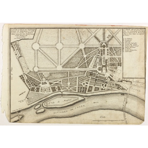
Plan de la belle et magnifique Maison de Monsieur A St Cloud . . .
Plan of the city of Saint Cloud, from Nicolas de Fer's "L'Atlas curieux ou le Monde réprésente dans des cartes. "The "Atlas Curieux" is a geographic encyclopedia of images and a celebration of the French Empire under the Sun King, with maps of French possessions in the western hemisphere, maps of France, with detailed views of the grand waterworks at Marly, views of the great palaces and chateaux, views and plans of the Paris Observatory, and samples of military architecture. Issued in six ann...
€60
Maker : DE FER, N.
Place : Paris
Date : 1705
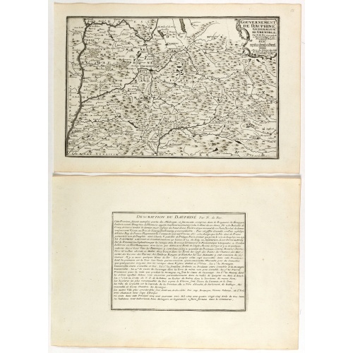
Gouvernement de Dauphiné, Generalité de Grenoble.
Map of the Dauphiné region, from Nicolas de Fer's "L'Atlas curieux ou le Monde réprésente dans des cartes. "The "Atlas Curieux" is a geographic encyclopedia of images and a celebration of the French Empire under the Sun King, with maps of French possessions in the western hemisphere, maps of France, with detailed views of the grand waterworks at Marly, views of the great palaces and chateaux, views and plans of the Paris Observatory, and samples of military architecture. Issued in six annual ...
€60
Maker : DE FER, N.
Place : Paris
Date : 1705
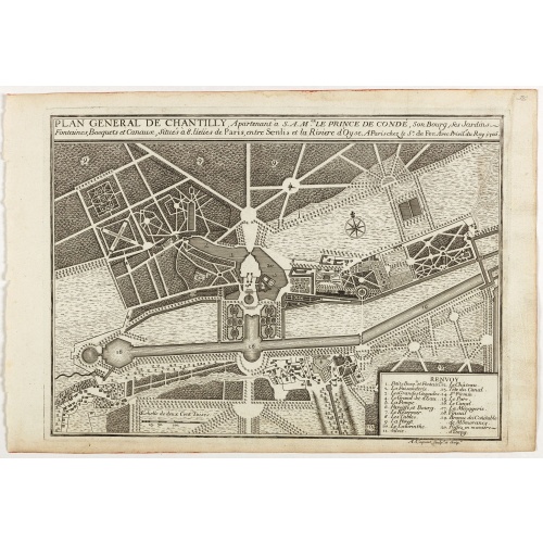
Plan general de Chantilly . . .
Plan of the city of Chantilly, from Nicolas de Fer's "L'Atlas curieux ou le Monde réprésente dans des cartes. "The "Atlas Curieux" is a geographic encyclopedia of images and a celebration of the French Empire under the Sun King, with maps of French possessions in the western hemisphere, maps of France, with detailed views of the grand waterworks at Marly, views of the great palaces and chateaux, views and plans of the Paris Observatory, and samples of military architecture. Issued in six annua...
€60
Maker : DE FER, N.
Place : Paris
Date : 1705
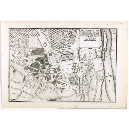
Plan general des chateaux et ville de St Germain en Laye.
City plan of St Germain en Laye, from Nicolas de Fer's "L'Atlas curieux ou le Monde réprésente dans des cartes. "The "Atlas Curieux" is a geographic encyclopedia of images and a celebration of the French Empire under the Sun King, with maps of French possessions in the western hemisphere, maps of France, with detailed views of the grand waterworks at Marly, views of the great palaces and chateaux, views and plans of the Paris Observatory, and samples of military architecture. Issued in six ann...
€60
Maker : DE FER, N.
Place : Paris
Date : 1705
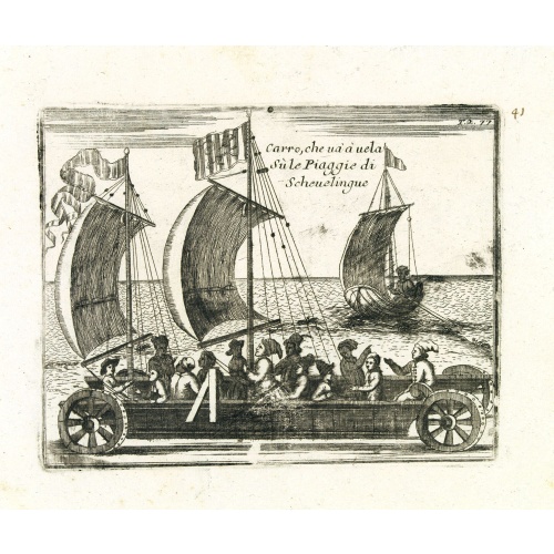
Carro, che uà à vela Su le Piagge di Schevelingue.
Italian version of Prince Maurits' sailing carriage designed by Simon Stevin. The big sailing-carriage could seat 28 persons and could reach a speed of seven miles per hour. The Prince often took his guests on a ride on the beaches of Scheveningen.
$225
Maker : CORONELLI, V.
Place : Venice
Date : 1707
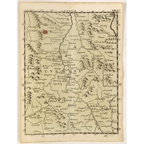
(Clermont, Brioude, Le Puy, etc.)
Rare miniature map including the towns of Clermont, Brioude, Le Puy, etc. From "Le theatre De Bellone, Contenant 48. nouvelles Cartes Geographiques, Des Païs-Bas Espagnols, Provinces-Unies, haute & basse Allemagne. . .". This rare atlas contained maps relating to the War of Spanish Succession. Published in Amsterdam by the widow of P. Schenk.
€60
Maker : SCHENK, P.
Place : Amsterdam
Date : 1710

Nieuwe en Nette Afteekening van het Eyland Corsica en het Eyland Elba vertoonende alle desselfs Havenen, Steeden en Rivieren . . .
Highly decorative large sea chart of Corsica, Sardinia and Elba, including multiple sailing ships, compass roses, cartouche, coat of arms, rhumb lines, topographical details, soundings, etc.Inset map of "Eyland Zlba of Ilva int Groot". Includes rhumb lines, topographical details, soundings, and a host of other details.
$4.000
Maker : VAN KEULEN, G.
Place : Amsterdam
Date : ca. 1710
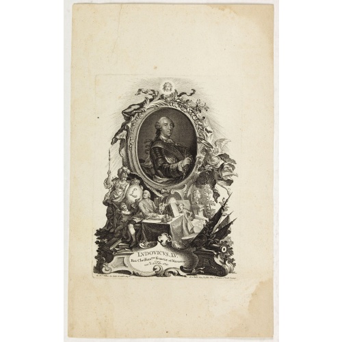
Ludovicus. XV rex chrisitan franciae et navarrae nat d:15. febr. 1710.
Portrait of Ludovicus XV, set in a decorative border.In lower part "Jo. Es. Nilson, inv et excutiv Aug V. et à Paris chez Rosselin Rue St. Jaques a l'Autel Saumur". Prepared by Johann Esaias Nilson (1721-88), 'the German Watteau'. Nilson was part of a family of artists and established himself as the leading Augsburg artist of his day, whose influence extended across publishing, art academies, a role as court painter, and the decorative arts (especially ceramics).Louis XV, known as Louis the Bel...
€50
Maker : NILSON, J.E.
Place : Augsburg, Paris
Date : 1710
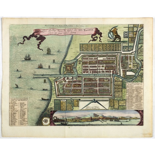
Ware affbeeldinge wegens het casteel ende stadt Batavia. . .
A reduced version of Clement de Jonghe (1650) plan of Jakarta from 1650. The town plan has a vignette at the bottom showing Jakarta from the sea with the volcanoes Mount Gede, Mount Pangrnago and Mount Salak in the background. Engraved for Arnoldus Montanus "Gedenkwaerdige gesantschappen der Oost-Indische maatschappy in ’t Vereenigde Nederland. . ." (1669) but reissued by Pieter van der AA.Batavia, present-day Jakarta, the Dutch center of trading activities in the East Indies. European and nat...
$800
Maker : VANDER AA, P.
Place : Leiden
Date : 1719
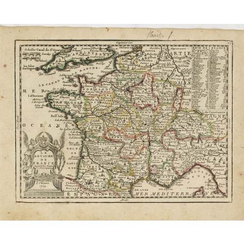
Le Royaume de France..
Lovely small map of France with decorative title cartouche and a panel in the upper right corner listing local rulers.From Le Nouveau et Curieux Atlas Geographique et Historique.. by Jacques Chiquet.Together with an engraved French text sheet entitled Le Royaume de France.
€75
Maker : CHIQUET, J.
Place : Paris
Date : 1719
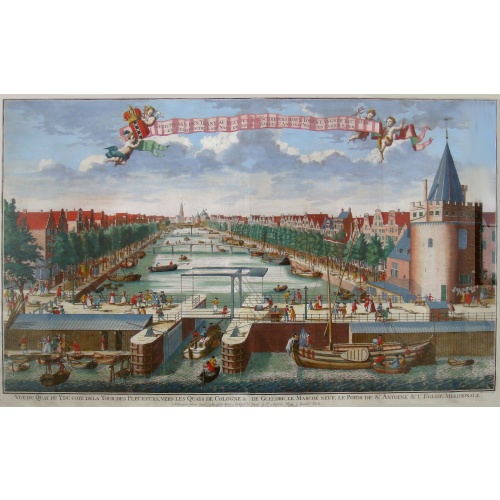
Beschrijving Gezicht van den Ykant af bezyden den Schreiers hoex Toren langs de Keulsche en Geldersche Kaei naer de Nieuwe Markt
This large engraving (560x920mm.) comes from a are series of 25 beautiful large views of Amsterdam and gives a colorful picture of the life and business of the city at the beginning of the 18th century. The print gives a view of the cityscape and architecture of that time. It also shows daily manners and customs and all kinds of scenes take place; There is a fight to the left of the bridge in the foreground (now Prins Hendrik Kade), while in front of the Scheierstoren quiet citizens read the not...
$2.000
Maker : DE LETH, H.
Place : Amsterdam
Date : ca 1720
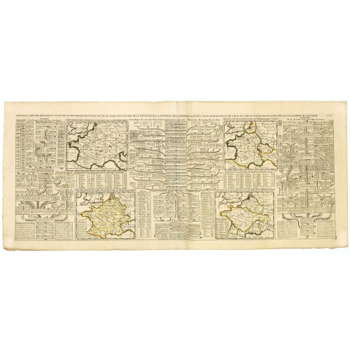
Nouvelle Carte des Differents Etats de la Monarchie Françoise Sous Iule Cesar, Sous les Rois de la Premiere, de la Seconde . . .
Four maps of France surrounded by historical and genealogical information to the history, chronology, ancient and modern genealogy of the french monarchy.Henri Abraham Chatelain (1684 – 1743) was a Huguenot pastor of Parisian origins. He lived consecutively in Paris, St. Martins, London (c. 1710), the Hague (c. 1721) and Amsterdam (c. 1728). He is best known as a Dutch cartographer and more specifically for his cartographic contribution in the seminal seven volume Atlas Historique, published f...
€75
Maker : CHATELAIN, H.
Place : Amsterdam
Date : 1720
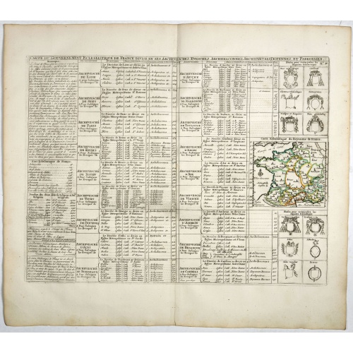
Carte du Gouvernement Ecclesiastique de France Divise en ses Archeveschez, Eveschez, Archidiaconnez, Archipretrez, Doyennez, et Parroisses.
This impressive plate provides a comprehensive list of the ecclesiastical divisions in the country with their corresponding coats of arms. A small inset map depicts the location of the various churches across France (95 x 105mm.)Zacharie Chatelain (d.1723) was the father of Henri Abraham (1684-1743) and Zacharie Junior (1690-1754).They worked as a partnership publishing the Atlas Historique, Ou Nouvelle Introduction A L’Histoire … under several different Chatelain imprints, depending on the ...
€55
Maker : CHATELAIN, H.
Place : Amsterdam, 1720
Date : 1720
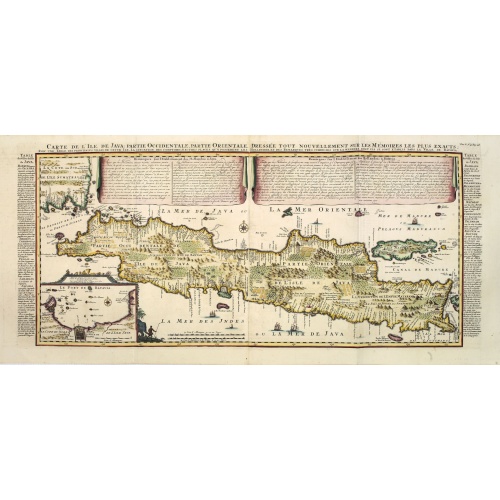
Carte de l'Ile de Java. . .
An inset plan of Batavia and clearly indicated rice fields, mountains, forests, towns in profile, and even elephants, suggesting the wealth of detail found on this map. Modeled on Hadrien Reland's important Dutch map of a few years earlier, the superb topographical detail is complemented by drapery style cartouche and side panels which provide a full French text description of the island, its topography, history, flora, fauna and inhabitants. Above the map are two drapery style title banners wri...
$1.750
Maker : CHATELAIN, H.
Place : Amsterdam
Date : 1720

Particularitez Curieuses de l'Ile de St. Christophle et de la Province de Bemarin . . .
Six meticulously detailed and engraved scenes of the island of St. Kitts, also known as Saint Christopher, and the province of Bemarin, indigenous plants, animals, reptiles, fish, crustaceans and insects.On a single sheet from Volume Six of Chatelain's "Atlas Historique".From left to right, top, the illustrations depict the French General's palace on St. Kitts, Indians visiting the French, and a landscape in Bemarin Province. Zacharie Chatelain (d.1723) was the father of Henri Abraham (1684-1743...
€95
Maker : CHATELAIN, H.
Place : Amsterdam
Date : 1720
![[Set of 2 maps of Caspian Sea.] Carte marine de la Mer Caspiene. Levee suivant les ordres de S.M. Czariene, P](/uploads/cache/86020-(1)-500x500.jpg)
[Set of 2 maps of Caspian Sea.] Carte marine de la Mer Caspiene. Levee suivant les ordres de S.M. Czariene, P
Guillaume de l' Isle (1675-1724), Royal Geographer, was the most influential cartographer of the first quarter of the 18th century. ' Atlas de Géographie' (1700-12), posthumous ' Atlas Nouveau' (1730). After the death of the widow of Pieter Mortier in 1719, the firm continued till 1778 as Covens & Mortier. They published numerous atlases and pocket atlases, using maps after de l' Isle and Jaillot.Two charts together depicting the Caspian Sea; the northern part of the Caspian Sea with insets dep...
€350
Maker : Guillaume Delisle
Place : Paris
Date : 1721

Very rare share in the Ostend Company. (4527)
Upper left hand corner share number 4527 in manuscript. In top emblem of the Ostend Company in copper engraving. Text: De Directeurs van de generale Keijserlijche- Indische compagnie, ordoneren aen hunnen cassier 'joan Baptist Cogels junior, te ontvangen van D'Heer Ferdinand Anthoin Baron de Veecquemans, Antwerp. de somme van tweehondert en vijftigh guldens wisselgeldt, voor het eerste payement sijnder actie van een duijsent guldens in het Capitael van de Selve compagnie, op de conditien in het ...
$2.000
Maker : OSTEND COMPANY
Place : Antwerp / Ostend
Date : 1723

Vertoog van het regt, Dat de Vereenigde Nederlandsche Oost-Indische maatschappye Heeft op de Vaart en Koophandel naar Oost-Indiën, Tegen de inwooners van de Spaanse, nu de Oostenrykse Nederlanden.
Dutch translation of the Latin edition, published in 1723. Westerveen was the secretary of the Dutch East India Company and writes on the right of the VOC to trade as well as on VOC maritime trade with the East Indies. Westerveen also addresses these matters with regard to the Dutch West India Company and deals with Dutch trade in the light of the interests of both Spain and Portugal in the Americas and in Asia.Also contains an interesting Extract uyt de Resolutien door den Gouverneur Generaal e...
$1.200
Maker : WESTERVEEN, A.
Place : Amsterdam
Date : 1724

Les Provinces des Pais Bas Autrichiens contenants en XXIV Feuilles les comtées d'Artois, de Flandres, de Hainaut, de Namur et des Duchées de Luxembourg…
Rare wall map of the Catholic of Austrian Low Countries, roughly the southern part of present-day The Netherlands, Belgium and Luxembourg. Map has some large cartouches, ships in the North Sea.
$1.500
Maker : SEUTTER, M.
Place : Augsburg, 1725
Date : 1725
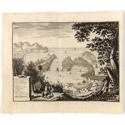
Haven van Aquapulco in ' Coninkryk van Nova Spagnien in de Zuyd Zee.
A finely engraved plan of the harbor, fort and village of Acapulco drawn from a hilltop vantage point looking out to sea. Several galleons are pictured approaching or anchored in the harbor. After Johannes Vingboons.François Valentijn (1666-1727), a missionary, worked at Amboina from 1684 to 1694 and 1705 to 1713 and traveled extensively in the VOC's lands. He is best known for his monumental history and description, "Oud en Nieuw Oost-Indiën" which remains one of the most important primary so...
€650
Maker : VALENTIJN, F.
Place : Amsterdam
Date : 1726