
![[How the Inca nobility are buried] / [Bridge of Huaynacapaco]](/uploads/cache/41094-(1)-500x500.jpg)
[How the Inca nobility are buried] / [Bridge of Huaynacapaco]
Two engravings. [470] The funeral of an Inca king was a ceremony of great splendor. After digging a large pit, the Indians would decorate the corpse with gold and silver then bury it with many fine ornaments, along with good food and wine to help it on its way into the next world. Benzoni so described the burial of Huayna-Capac, whose grave he said was on the border of the province of Quito. When the Spanish first went to Peru, they discovered and pillaged many such graves.[469] Much of Ecuador ...
$80
Maker : GOTTFRIED, J.L. / DE BRY.
Place : Frankfurt, M.Merian
Date : 1633
![[How natives of Paria cope with illness] / Vespucci reaches Lake Maracaibo]..](/uploads/cache/41095-(2)-500x500.jpg)
[How natives of Paria cope with illness] / Vespucci reaches Lake Maracaibo]..
Two engravings. [421b] When the natives of those parts, they were bathed in a cold stream, then chased round a blazing fire until they had dried out. Then they were put to bed and great care was taken to ensure their loins were dry. Vomiting was overcome by fasting for three or four days and paying careful attention to diet., which rarely included meat, except for human flesh, of which they were inordinately fond. In fact they would even fatten their enemy captives before eating them and seemed ...
$80
Maker : GOTTFRIED, J.L. / DE BRY.
Place : Frankfurt, M.Merian
Date : 1633
![[Spilbergen's fleet visits the island of Santa Maria] / [The Dutch visit Isla Mocha].](/uploads/cache/41090-(1)-500x500.jpg)
[Spilbergen's fleet visits the island of Santa Maria] / [The Dutch visit Isla Mocha].
Two engravings. [514] On 29th May, 1615, Spilbergen’s fleet anchored further north, off an island called Santa María that was separated by a narrow stretch of water (A), from Punta Lavapié on the mainland. Four of the ships (I) anchored in the bay, while the fifth (H) anchored closer. The Dutch went ashore in small boats (F), where they saw Spanish soldiers on horseback (B), so they arranged themselves for battle (C). There were several confrontations (E), during which many Dutchmen died but...
$80
Maker : GOTTFRIED, J.L. / DE BRY.
Place : Frankfurt, M.Merian
Date : 1633
![[How the Indians cured the Spanish thirst for gold....by pouring it down their throats!]](/uploads/cache/40483-(1)-500x500.jpg)
[How the Indians cured the Spanish thirst for gold....by pouring it down their throats!]
A brutal scene depicting native Indians tying down Spanish men and pouring liquid gold down their throats. Scenes of cannibalism in the background.In 1631 Johann Ludwig Gottfried, inherited the Theodor De Bry’s publishing firm, among the illustrated accounts of the expeditions of Magellan, Columbus, Vespucci, Cortes, Balboa, Raleigh, Drake, Smith, and many others.Gottfried issued together with Matthaeus Merian a one-volume condensation "Newe Welt Vnd Americanische Historien/ Jnhaltende Warhaff...
$80
Maker : GOTTFRIED, J.L. / DE BRY.
Place : Frankfurt, M.Merian
Date : 1633
![[Diego de Almagro is killed.]](/uploads/cache/40354-500x500.jpg)
[Diego de Almagro is killed.]
Almagro returned to Cuzco, disillusioned and embittered from his long and fruitless journey south into Chile, where he had been searching for further wealth. This led to a split in the control of Peru between the Pizarrists, who held the coastal regions, and the Almagrists who held the Cordillera. Further quarreling culminated in a battle just outside Cuzco in 1538, known as Las Salinas, which the Pizarrists eventually won. Almagro was subsequently garrotted and his captain, Orgóñez, beheaded....
$80
Maker : GOTTFRIED, J.L. / DE BRY.
Place : Frankfurt, M.Merian
Date : 1633
![[Cavendish reaches Morro Moreno.]](/uploads/cache/39910-500x500.jpg)
[Cavendish reaches Morro Moreno.]
Scarce print with a German text sheet showing Cavendish’s fleet anchor at a place called Morro Moreno, on the coast of Chile. The Indians came down from the high cliffs to greet the voyagers and brought with them firewood and fresh water as a sign of friendship. Later the English were taken to their homes, which were made from two sticks in the ground, with others laid across and covered with straw. The whole family, including children, lay underneath on animal skins. They were skilled fisherm...
$80
Maker : GOTTFRIED, J.L. / DE BRY.
Place : Frankfurt, M.Merian
Date : 1633
![[French seizure of Chiorera.]](/uploads/cache/39911-500x500.jpg)
[French seizure of Chiorera.]
Scarce print with a German text sheet showing the French torching and looting Chiorera. From de Bry's "Great American Voyages". Johann Theodor de Bry (1561-1623) was born in Liège in 1561, the eldest son of the engraver and publisher Theodor de Bry. It was from his father that Johann learned his craft, producing both engravings and etchings. In 1588, the Lutheran De Bry family settled in Frankfurt am Main, a safe haven for Lutherans at this time of religious discord. Together with his father an...
$80
Maker : GOTTFRIED, J.L. / DE BRY.
Place : Frankfurt, M.Merian
Date : 1633
-500x500.jpg)
Peru.
FIRST EDITION, FIRST ISSUE OF THIS MAP. Decorated with ships and monsters in the sea. Orientated with east at the top. With the signature of G. Blaeuw lower right corner. Shows the Pacific coast of South America from Ecuador (at the left-hand side) as far south as the Atacama desert in the northern reaches of Chile. "As early as 1520, Spanish settlers in Panama had heard tales of a powerful civilization rich in gold that lay to the south, and in 1522 an expedition was organized to find this land...
$900
Maker : BLAEU, W.
Place : Amsterdam
Date : 1644
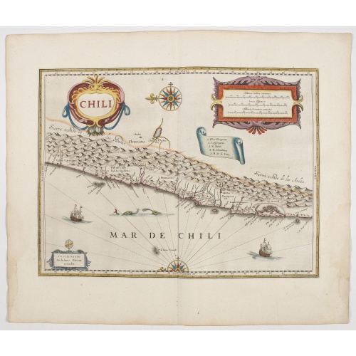
Chili.
Willem Blaeu's very decorative map of Chili with two large and beautiful cartouches, a compass and ships. From early on Willem Jansz. Blaeu aimed of publishing an atlas to compete with the Hondius-Janssonius Atlas. By 1630, he had published at least 17 folio size maps. Blaeu was able to realize his plan soon after he had acquired the copper plates of the atlas maps by Jodocus Hondius. The "Appendix followed in 1630.In 1635 he finally realized a "international edition" of a world atlas, the "The...
$900
Maker : BLAEU, W.
Place : Amsterdam, 1644
Date : 1644
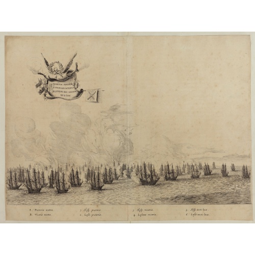
Quartum Praelium Coniovian inter et Fluvium Rio Grande XVII Ian
Decorative engraving of the fourth sea battle with the Portuguese fleet offshore at the Rio Grande, in 1640. Engraved by J. van Brosterhuyzen after a design by Frans J. Post (1612-1680). Below the engraving a numbered key (1-6). Signed in the plate "F. Post 1645" and decorative title cartouche, with "[Quartum praelium coniovian inter et fluvium Rio Grande XVII Jan" in the upper left corner.Taken from C. BARLAEUS, Rerum per octennium in Brasilia (...).
$450
Maker : POST, F. J.
Place : Joannes Blaeu, Amsterdam 1647
Date : 1647
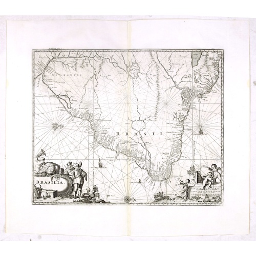
Brasilia.
Very fine decorative map od Brazil with west to the top. From the book "A Collection of Voyages and Travels" by Churchill and the map came from the part containing a description Nieuhoff's travels in Brazil.
$550
Maker : CHURCHIL, J.
Place : London, Printed for A. and J. Churchill
Date : 1703
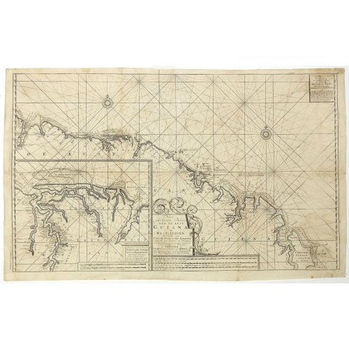
Nieuwe gelyk Graadige Paskaart van de Kust van Guiana in West-Indien.
Detailed chart of Guiana in South America. Two scales are given in both maps: Dutch, French and English nautical miles.The inset chart provide detailed view of the Camopi and Maroni or Marowijne Rivers that forms the border between French Guiana and Suriname. The charts are prepared by Johannes Loots and H.Mooy.
$650
Maker : VAN KEULEN, G.
Place : Amsterdam
Date : 1684 - 1704
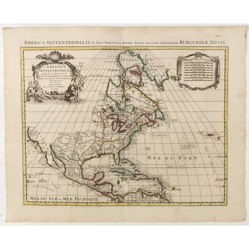
L'Amerique septentrionale, Dressée sur les memoires les plus recens. . .
A very detailed map extending from Hudsons Bay to Panama, and including the West Indies. The map is a later copy of Guillaume de L'Isle's foundation map of North America, originally prepared in 1700.The de L'Isle was one of the earliest maps to restore the peninsula form for California, and has a much improved outline for the Great Lakes and Mississippi valley.The map shows select towns and cities, forts, Indian villages and tribal territory and relief.
$900
Maker : COVENS, J. / MORTIER, C.
Place : Amsterdam
Date : 1739

Carta esférica del Rio de la Plata : desde su embocadura hasta Buenos Aires.
Large nautical chart illustrating the estuary formed by the combination of the Uruguay River and the Paraná River. It forms part of the border between Argentina and Uruguay, with the major ports and capital cities of Buenos Aires in the southwest and Montevideo in the northeast.
$750
Maker : DIRECTION HIDROGRAFICA
Place : Madrid
Date : 1812-1838

Amérique Méridionale.
Map of South America.Lovely map from one of the last decorative atlases of the nineteenth century.The rather simple map is framed by horses, Indians, jaguars, tapirs, and mining, as well as personifications of the rivers Amazon and La Plata at the top of the map. Victor Levasseur's "Atlas National Illustré" and "Atlas Universel Illustré" are among the last great decorative atlases published. This map comes from the Atlas National Illustré.
$90
Maker : LEVASSEUR, V.
Place : Paris, A. Combette
Date : 1852

A general chart of the South Atlantic Ocean Drawn by J.W.Norie hydrographer. Revised & Corrected 1854.
A 2-sheet chart of the South Atlantic Ocean, showing the coast of South America from the mouth of the Amazon to Quito in Peru. The right hand part showing Africa's coast at Angola. Scale: circa 1:8,000,000. Chart of the South Atlantic, in two sheets. Two insets, Port of Ascension and Anchorage off N.W. side of St. Helena.The chart is published for the first time in 1833, according to a date lower part map. This is A Revised & corrected edition by J.W. Norie in 1854
$600
Maker : NORIE, J.W.
Place : London
Date : 1854